METAR & TAF 58N
58N does not publish a METAR.
Showing the nearest reporting station: KMDT (HARRISBURG INTL) · 10.2 NM away. Conditions at 58N may differ.
METAR · KMDT
Observed 09:56Z
KMDT 250956Z 05003KT 10SM BKN100 BKN210 18/14 A3013 RMK AO2 SLP201 T01830144
- Wind
- 050° @ 3 kt
- Visibility
- 10 SM
- Temp / Dew
- 18°C / 14°C
- Altimeter
- 30.13 inHg
- Clouds
- BKN
- Density alt
- 706 ft
- Ceiling
- 10,000 ft AGL
- Rules
- VFR
Airport info & contacts
Manager on record, flight service, ARTCC, attendance schedule and pattern altitude — published by the FAA and refreshed every 28 days.
Location
- From city
- 2 NM S
- VFR sectional
- NEW YORK
- ARTCC
- ZNY · NEW YORK
- NOTAM facility
- IPT (NOTAM-D)
Airport manager
- Name
- MICHELLE WOLF
- Phone
- 717-838-5519
- Address
- 1805 S FORGE RD, PALMYRA PA 17078
Flight service · Hours
- FSS IPT
- WILLIAMSPORT1-800-WX-BRIEF
- Attendance
- 0900-1700
Frequencies
Tap any row to copy the frequency to your clipboard.
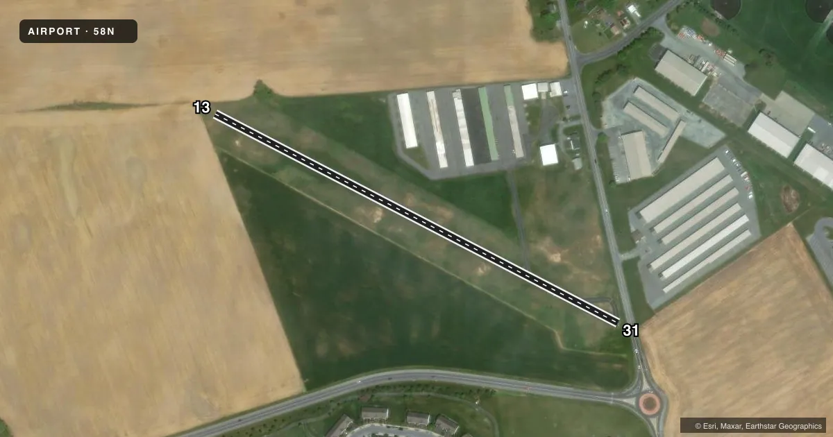
Runways & pattern
Full pagePattern entry · RWY 13
LEFT TRAFFICAirport sketch
Runways drawn to scale from FAA survey coordinates, rendered over satellite imagery. Not for navigation.
Approaches & charts
Services on the field
Fuel grades, oxygen, maintenance, ramp storage and lighting — as declared to the FAA by the airport operator.
Fuel & services
- Fuel
- 100LL
- Airframe repair
- Major
- Power plant repair
- Major
- Other services
- INSTR,RNTL
Ramp & ground
- Transient storage
- Tie-down
- Hangar
- Customs
- Not available
- Lighting schedule
- SEE RMK
- Beacon schedule
- SEE RMK
- Beacon
- White / Green (civil land)(WG)
- Wind indicator
- Yes
- Segmented circle
- No
Fuel & FBOs
Cheapest 100LL and Jet A on the field and nearby. Always confirm with the FBO before taxi.
Airport notes
Surface conditions, obstructions, local procedures, lighting outages and other notes published with each FAA cycle.
General notes
- FOR CD CTC HARRISBURG APCH AT 800-932-0712.
Lighting notes
- ACTVT ROTG BCN - CTAF.
- ACTVT LIRL RWY 13/31 - CTAF.
Runway surface & condition
- 13/31NSTD LIRL; LGTS LCTD 125 FT L AND R OF CNTRLN. RWY 13; FIRST 110 FT UNLGTD. RWY 31; FIRST 60 FT UNLGTD. 1780 FT OF RWY LGTD.
Approach & departure obstructions
- 13RWY 13 CROPS 132 FT FM RWY.
- 31+15 FT ROAD 25-60 FT FROM RWY.
- 31DSPLCD THLD IDENTIFIED AT NIGHT BY ONE GREEN LGT EACH SIDE OF RWY.
- 31CTLNG OBSTN GTR THAN 45 DEG SLP.
VFR map & nearby airports
VFR sectional. Tap any ICAO chip to open that airport.
Key facts · 58N
Answer card- ICAO
- 58N
- Name
- REIGLE FLD
- Location
- PALMYRA, PENNSYLVANIA
- Elevation
- 489 ft MSL
- Traffic pattern altitude
- 1,489 ft MSL (1,000 AGL)
- Control tower
- Non-towered (use CTAF)
- Total runways
- 1
- Longest runway
- 13/31 · 1,955 ft
- Published ILS approaches
- 0
- Published frequencies
- 8
- Magnetic variation
- 10°
- Current flight rules
- VFR
- Current wind
- 050° at 3 kt
- Favored runway now
- RWY 13
Reigle Fld sits in Palmyra, Pennsylvania. Field elevation is 489 ft MSL. The airport has one runway. Runway 13/31 is 1,955 ft long with an asphalt surface. There is no control tower. The published pattern altitude is not listed, so use the standard 1,000 ft AGL for light piston operations unless the current Chart Supplement says otherwise.
No ILS approaches are published here. Harrisburg Approach handles the area. Published frequencies are on the field data. For clearance delivery, the published remark says to contact Harrisburg Approach at 800-932-0712. Reigle Aviation is on the field. It carries 100LL. If you need fuel or local handling details, call them before departure.
This is a short runway with published lighting and obstruction notes that matter. Runway 13/31 has low intensity lights. The first part of each end is unlighted. The remarks also note crops near runway 13. They note a road close to runway 31. They also note a controlling obstruction on the 31 end. The displaced threshold on runway 31 is marked at night by green lights on each side of the runway. Plan your arrival with those limits in mind. Check the current Chart Supplement for any noise or operational restrictions before flying in.