METAR & TAF N79
Current METAR
Observed 13:35Z
KN79 251335Z AUTO VRB03KT 10SM CLR 22/15 A3012 RMK AO2 T02220153
- Wind
- VAR @ 3 kt
- Visibility
- 10 SM
- Temp / Dew
- 22°C / 15°C
- Altimeter
- 30.12 inHg
- Clouds
- CLR
- Density alt
- 1,684 ft
- Ceiling
- Unlimited
- Rules
- VFR
Airport info & contacts
Manager on record, flight service, ARTCC, attendance schedule and pattern altitude — published by the FAA and refreshed every 28 days.
Location
- From city
- 3 NM N
- VFR sectional
- NEW YORK
- ARTCC
- ZNY · NEW YORK
- NOTAM facility
- IPT (NOTAM-D)
Airport manager
- Name
- RON SMITH
- Phone
- 570-898-8588
- Address
- PO BOX 94, PAXINOS PA 17860
Flight service · Hours
- FSS IPT
- WILLIAMSPORT1-800-WX-BRIEF
- Attendance
- SAT-SUN · ON CALL
- MON-FRI · 0800-1400
Frequencies
Tap any row to copy the frequency to your clipboard.
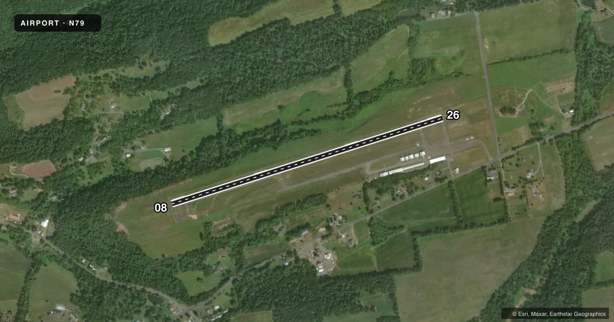
Runways & pattern
Full pagePattern entry · RWY 08
LEFT TRAFFICRunway end performance
| End | TORA | TODA | ASDA | LDA | VGSI | Approach lights | Obstruction |
|---|---|---|---|---|---|---|---|
| 08 | — | — | — | — | PAPI 2-box left(3°) | — | 17', trees, 330' from thr, 214' R of cntrln, slope 7 |
| 26 | — | — | — | — | PAPI 2-box left(3°) | — | — |
Declared distances in feet. TORA = takeoff run available, TODA = takeoff distance, ASDA = accelerate-stop, LDA = landing distance.
Airport sketch
Runways drawn to scale from FAA survey coordinates, rendered over satellite imagery. Not for navigation.
Approaches & charts
Services on the field
Fuel grades, oxygen, maintenance, ramp storage and lighting — as declared to the FAA by the airport operator.
Fuel & services
- Fuel
- 100LLA
- Oxygen (bottled)
- Not available
- Oxygen (bulk)
- Not available
- Airframe repair
- Not available
- Power plant repair
- Not available
Ramp & ground
- Transient storage
- Tie-down
- Landing fee
- No fee published
- Customs
- Not available
- Lighting schedule
- SEE RMK
- Beacon schedule
- SS-SR
- Beacon
- White / Green (civil land)(WG)
- Wind indicator
- Lighted
- Segmented circle
- No
Fuel & FBOs
Cheapest 100LL and Jet A on the field and nearby. Always confirm with the FBO before taxi.
Airport notes
Surface conditions, obstructions, local procedures, lighting outages and other notes published with each FAA cycle.
General notes
- FOR CD CTC HARRISBURG APCH AT 800-932-0712.
Lighting notes
- ACTVT REIL RWY 08 & 26; PAPI RWY 08 & 26; MIRL RWY 08/26 - 121.8.
Approach & departure obstructions
- 08RWY 08 TREES/BRUSH 165 L OF CNTRLN PARL TO RWY FROM THLD OUT TO 200 FT.
- 08RWY 08 PAPI UNUSBL BYD 7 DEG RIGHT OF CNTRLN.
- 26PAPI UNUSBL BYD 8 DEG LEFT & BYD 6 DEG RIGHT OF RWY CNTRLN.
Other notes
- EXISTED PRIOR TO 1959.
- OWNERAFT HRS: 570-898-8588
VFR map & nearby airports
VFR sectional. Tap any ICAO chip to open that airport.
Key facts · N79
Answer card- ICAO
- N79
- Name
- NORTHUMBERLAND COUNTY
- Location
- SHAMOKIN, PENNSYLVANIA
- Elevation
- 880.6 ft MSL
- Traffic pattern altitude
- 1,880.6 ft MSL (1,000 AGL)
- Control tower
- Non-towered (use CTAF)
- Total runways
- 1
- Longest runway
- 08/26 · 3,297 ft
- Published ILS approaches
- 0
- Published frequencies
- 4
- Magnetic variation
- 11°
- Current flight rules
- VFR
- Current wind
- 000° at 3 kt
- Favored runway now
- RWY 08
Northumberland County Airport sits near Shamokin, Pennsylvania. Field elevation is 880.6 ft MSL. The airport has one runway. Runway 08/26 is 3,297 ft long with an asphalt surface. There is no control tower. No ILS approaches are published here. The pattern altitude is not published, so use the standard 1,000 ft AGL for light piston operations unless the current FAA Chart Supplement says otherwise.
The on-field FBO is Northumberland County Airport. It carries AVGAS 100LL and Jet A. Call (570) 672-1321 before arrival if you need current service details. Published remarks note runway end identifier lights and medium intensity runway lights on 08/26. The PAPI is installed on both ends. The 08 PAPI has limits near centerline that matter if you drift right. The 26 PAPI has limits if you get too far left or right of centerline. Trees and brush sit 165 ft left of the 08 centerline from the threshold out to 200 ft, so keep that in mind on departure and landing. This field uses Harrisburg Approach for clearance delivery. The airport is non-towered, so expect CTAF and UNICOM self-announce traffic. Check the current FAA Chart Supplement for any published noise or curfew restrictions before flying in.