METAR & TAF 8N8
8N8 does not publish a METAR.
Showing the nearest reporting station: KSEG (PENN VALLEY) · 12.6 NM away. Conditions at 8N8 may differ.
METAR · KSEG
Observed 22:53Z
KSEG 262253Z AUTO 00000KT 10SM BKN070 OVC085 28/16 A2984 RMK AO2 SLP099 T02780156
- Wind
- 000° @ 0 kt
- Visibility
- 10 SM
- Temp / Dew
- 28°C / 16°C
- Altimeter
- 29.84 inHg
- Clouds
- OVC
- Density alt
- 2,352 ft
- Ceiling
- 7,000 ft AGL
- Rules
- VFR
Airport info & contacts
Manager on record, flight service, ARTCC, attendance schedule and pattern altitude — published by the FAA and refreshed every 28 days.
Location
- From city
- 3 NM SW
- VFR sectional
- NEW YORK
- ARTCC
- ZNY · NEW YORK
- NOTAM facility
- IPT (NOTAM-D)
Airport manager
- Name
- CRAIG LAWLER
- Phone
- 570-274-6190
- Address
- 1413 SUNBURY ROAD, DANVILLE PA 17824
Flight service · Hours
- FSS IPT
- WILLIAMSPORT1-800-WX-BRIEF
- Attendance
- IRREGULAR
Frequencies
Tap any row to copy the frequency to your clipboard.
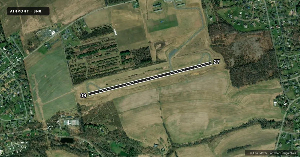
Runways & pattern
Full pagePattern entry · RWY 09
LEFT TRAFFICRunway end performance
| End | TORA | TODA | ASDA | LDA | VGSI | Approach lights | Obstruction |
|---|---|---|---|---|---|---|---|
| 09 | — | — | — | — | — | — | 50', trees, 314' from thr, 246' R of cntrln, slope 2 |
| 27 | — | — | — | — | — | — | 14', trees, 290' from thr, 137' R of cntrln, slope 6 |
Declared distances in feet. TORA = takeoff run available, TODA = takeoff distance, ASDA = accelerate-stop, LDA = landing distance.
Airport sketch
Runways drawn to scale from FAA survey coordinates, rendered over satellite imagery. Not for navigation.
Approaches & charts
Services on the field
Fuel grades, oxygen, maintenance, ramp storage and lighting — as declared to the FAA by the airport operator.
Fuel & services
- Fuel
- Not available
- Oxygen (bottled)
- Not available
- Oxygen (bulk)
- Not available
- Airframe repair
- Major
- Power plant repair
- Major
Ramp & ground
- Transient storage
- Tie-down
- Landing fee
- No fee published
- Customs
- Not available
- Lighting schedule
- SEE RMK
- Beacon
- White / Green (civil land)(WG)
- Wind indicator
- Yes
- Segmented circle
- Yes
Fuel & FBOs
Cheapest 100LL and Jet A on the field and nearby. Always confirm with the FBO before taxi.
Airport notes
Surface conditions, obstructions, local procedures, lighting outages and other notes published with each FAA cycle.
General notes
- DEER & WILDLIFE ON & INVOF ARPT.
- RC AIRPLANE OPS N OF RWY.
- FOR CD CTC WILKES-BARRE APCH AT 570-655-2084.
- LIGHTING NON-STANDARD
- MAIN RAMP NO PROP WASH INVOF MAIN HNGR DUE TO ACFT PAINTING.
Lighting notes
- ACTVT MIRL RWY 09/27 DRG PERIODS OF DARKNESS ONLY - CTAF.
Approach & departure obstructions
- 27THR LGTS DSPLCD 365 FT FM RWY END FOR NGT DISPLACEMENT. RWY END LGTD WITH TWO RED LGTS ON LEFT SIDE (NON STD).
Other notes
- EXISTED PRIOR TO MAY 15 1959
- 1AFT HRS CTC 570-274-6190.
VFR map & nearby airports
VFR sectional. Tap any ICAO chip to open that airport.
Key facts · 8N8
Answer card- ICAO
- 8N8
- Name
- DANVILLE
- Location
- DANVILLE, PENNSYLVANIA
- Elevation
- 559 ft MSL
- Traffic pattern altitude
- 1,559 ft MSL (1,000 AGL)
- Control tower
- Non-towered (use CTAF)
- Total runways
- 1
- Longest runway
- 09/27 · 3,000 ft
- Published ILS approaches
- 0
- Published frequencies
- 4
- Magnetic variation
- 12°
- Current flight rules
- VFR
- Current wind
- 000° at 0 kt
- Favored runway now
- –
Danville Airport sits in Danville, Pennsylvania. Field elevation is 559 ft MSL. It has one runway, 09/27, which is 3,000 ft asphalt. There is no control tower. No ILS approaches are published. Pattern altitude is not published, so use 1,000 ft AGL for light piston traffic unless the current Chart Supplement says otherwise.
This is a non-towered field with CTAF and UNICOM both on 122.8. Wilkes-Barre Approach handles clearance delivery. The published frequencies are 126.3 and 256.7. The runway lights are non-standard. Medium intensity runway lights on 09/27 are activated only at night. They are controlled by CTAF. The runway 27 end has displaced threshold lighting for night use, so brief your landing distance carefully before arrival.
The published remarks matter here. Deer and wildlife are reported on and near the airport. Radio-controlled airplane operations occur north of the runway. No propeller wash is allowed near the main hangar on the main ramp because of aircraft painting. There are no on-field FBOs listed. Contact the airport operator directly or call the field on CTAF or UNICOM for current fuel and service availability. For clearance delivery after hours, the published phone number is 570-274-6190.