METAR & TAF KSEG
Current METAR
Observed 03:53Z
KSEG 270353Z AUTO 00000KT 10SM FEW110 18/17 A2985 RMK AO2 SLP106 T01830167
- Wind
- 000° @ 0 kt
- Visibility
- 10 SM
- Temp / Dew
- 18°C / 17°C
- Altimeter
- 29.85 inHg
- Clouds
- FEW
- Density alt
- 1,022 ft
- Ceiling
- Unlimited
- Rules
- VFR
Airport info & contacts
Manager on record, flight service, ARTCC, attendance schedule and pattern altitude — published by the FAA and refreshed every 28 days.
Location
- From city
- 1 NM N
- VFR sectional
- NEW YORK
- ARTCC
- ZNY · NEW YORK
- NOTAM facility
- SEG (NOTAM-D)
Airport manager
- Name
- STEPHEN BOWERS
- Phone
- 570-809-4701
- Address
- 100 AIRPORT RD, SELINSGROVE PA 17870
Flight service · Hours
- FSS IPT
- WILLIAMSPORT1-800-WX-BRIEF
- Attendance
- SAT-SUN · 0800-1600
- MON-FRI · 0800-1800
Frequencies
Tap any row to copy the frequency to your clipboard.
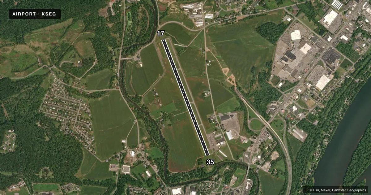
Runways & pattern
Full pagePattern entry · RWY 17
LEFT TRAFFICRunway end performance
| End | TORA | TODA | ASDA | LDA | VGSI | Approach lights | Obstruction |
|---|---|---|---|---|---|---|---|
| 17 | — | — | — | — | — | — | 42', tree, 608' from thr, 238' R of cntrln, slope 9 |
| 35 | — | — | — | — | PAPI 4-box left(3.5°) | — | 38', trees, 432' from thr, 281' R of cntrln, slope 6 |
Declared distances in feet. TORA = takeoff run available, TODA = takeoff distance, ASDA = accelerate-stop, LDA = landing distance.
Airport sketch
Runways drawn to scale from FAA survey coordinates, rendered over satellite imagery. Not for navigation.
Approaches & charts
Services on the field
Fuel grades, oxygen, maintenance, ramp storage and lighting — as declared to the FAA by the airport operator.
Fuel & services
- Fuel
- 100LLA
- Oxygen (bottled)
- Not available
- Oxygen (bulk)
- Not available
- Airframe repair
- Minor
- Power plant repair
- Minor
- Other services
- INSTR
Ramp & ground
- Transient storage
- Tie-down
- Hangar
- Landing fee
- Yes
- Customs
- Not available
- Lighting schedule
- SEE RMK
- Beacon schedule
- SS-SR
- Beacon
- White / Green (civil land)(WG)
- Wind indicator
- Lighted
- Segmented circle
- No
Fuel & FBOs
Cheapest 100LL and Jet A on the field and nearby. Always confirm with the FBO before taxi.
Airport notes
Surface conditions, obstructions, local procedures, lighting outages and other notes published with each FAA cycle.
General notes
- FOR CD CTC HARRISBURG APCH AT 800-932-0712.
- DEER & BIRDS ON AND INVOF ARPT.
- RISING TERRAIN BOTH SIDES OF APCH TO RWY 17..
- COLD TEMPERATURE AIRPORT. ALTITUDE CORRECTION REQUIRED AT OR BELOW -13C.
Lighting notes
- ACTVT REIL RWY 17/35; PAPI RWY 35; MIRL RWY 17/35 - CTAF.
Approach & departure obstructions
- 1724:1 APCH SLP TO DTHR.
- 35APCH SLP 18:1 TO DTHR.
Other notes
- RAMP FEE FOR TWIN ENG & LRGR ACFT UNLESS FUEL PURCHASED.
- MANAGERAFT HOURS CTC 570-809-4701.
VFR map & nearby airports
VFR sectional. Tap any ICAO chip to open that airport.
Key facts · KSEG
Answer card- ICAO
- KSEG
- Name
- PENN VALLEY
- Location
- SELINSGROVE, PENNSYLVANIA
- Elevation
- 463.5 ft MSL
- Traffic pattern altitude
- 1,463.5 ft MSL (1,000 AGL)
- Control tower
- Non-towered (use CTAF)
- Total runways
- 1
- Longest runway
- 17/35 · 4,760 ft
- Published ILS approaches
- 0
- Published frequencies
- 4
- Magnetic variation
- 11°
- Current flight rules
- VFR
- Current wind
- 000° at 0 kt
- Favored runway now
- –
Penn Valley Airport sits in Selinsgrove, Pennsylvania. The field elevation is 463.5 ft MSL. It has one runway, 17/35, which is 4,760 ft long. There is no control tower. Traffic uses CTAF 122.7. The published pattern altitude is not listed, so use the standard 1,000 ft AGL unless the current Chart Supplement says otherwise.
No ILS approaches are published here. Runway lighting is installed on 17/35. Runway end identifier lights are active. PAPI is installed on runway 35. The published remarks also call out displaced threshold approach slopes on both ends. Runway 17 has rising terrain on both sides of the approach. Deer and birds are also noted on and near the airport, so keep a sharp scan on short final and in the pattern.
Penn Valley Airport is the on-field FBO. It carries 100LL and Jet A with Prist. Call (570) 374-7671 for current service details. For clearance delivery, contact Harrisburg Approach at 800-932-0712. This is also a cold temperature airport. Altitude correction is required at or below minus 13 degrees Celsius. If you are bringing a twin or larger aircraft, ask about the ramp fee before arrival unless you are buying fuel.