METAR & TAF N13
N13 does not publish a METAR.
Showing the nearest reporting station: KZER (SCHUYLKILL COUNTY/JOE ZERBEY) · 17.7 NM away. Conditions at N13 may differ.
METAR · KZER
Observed 12:35Z
KZER 271235Z AUTO 32004KT 10SM CLR 20/16 A2992 RMK AO2
- Wind
- 320° @ 4 kt
- Visibility
- 10 SM
- Temp / Dew
- 20°C / 16°C
- Altimeter
- 29.92 inHg
- Clouds
- CLR
- Density alt
- 1,197 ft
- Ceiling
- Unlimited
- Rules
- VFR
Airport info & contacts
Manager on record, flight service, ARTCC, attendance schedule and pattern altitude — published by the FAA and refreshed every 28 days.
Location
- From city
- 0 NM E
- VFR sectional
- NEW YORK
- ARTCC
- ZNY · NEW YORK
- NOTAM facility
- IPT (NOTAM-D)
Airport manager
- Name
- DAN BROADT
- Phone
- 570-317-1966
- Address
- 301 AIRPORT ROAD, BLOOMSBURG PA 17815-9588
Flight service · Hours
- FSS IPT
- WILLIAMSPORT1-800-WX-BRIEF
- Attendance
- MON-FRI · IRREGULAR
- SAT-SUN · IRREGULAR
Frequencies
Tap any row to copy the frequency to your clipboard.
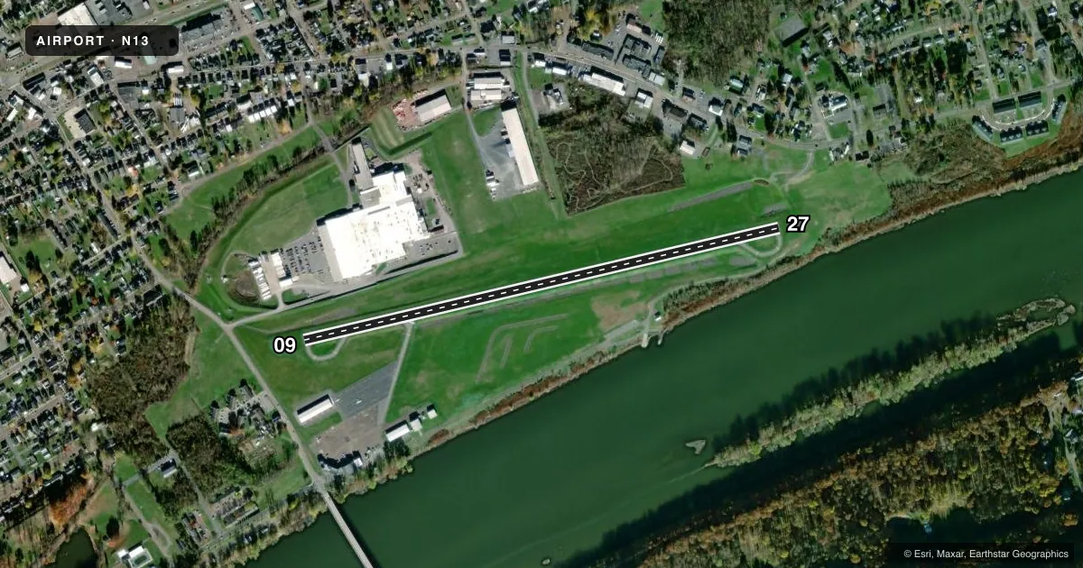
Runways & pattern
Full pagePattern entry · RWY 27
LEFT TRAFFICRunway end performance
| End | TORA | TODA | ASDA | LDA | VGSI | Approach lights | Obstruction |
|---|---|---|---|---|---|---|---|
| 09 | — | — | — | — | — | — | 12', road, 386' from thr, 6' R of cntrln, slope 15 |
Declared distances in feet. TORA = takeoff run available, TODA = takeoff distance, ASDA = accelerate-stop, LDA = landing distance.
Airport sketch
Runways drawn to scale from FAA survey coordinates, rendered over satellite imagery. Not for navigation.
Approaches & charts
Services on the field
Fuel grades, oxygen, maintenance, ramp storage and lighting — as declared to the FAA by the airport operator.
Fuel & services
- Fuel
- 100LL
- Oxygen (bottled)
- Not available
- Oxygen (bulk)
- Not available
- Airframe repair
- Major
- Power plant repair
- Major
- Other services
- INSTR
Ramp & ground
- Transient storage
- Tie-down
- Landing fee
- No fee published
- Customs
- Not available
- Lighting schedule
- SEE RMK
- Beacon schedule
- SS-SR
- Beacon
- White / Green (civil land)(WG)
- Wind indicator
- Yes
- Segmented circle
- No
Fuel & FBOs
Cheapest 100LL and Jet A on the field and nearby. Always confirm with the FBO before taxi.
Airport notes
Surface conditions, obstructions, local procedures, lighting outages and other notes published with each FAA cycle.
General notes
- DEER AND GEESE INVOF RWY. AFT DUSK, RWY 9 PREF DUE TO DEER ACT EAST END OF ARPT
- FOR CD CTC WILKES-BARRE APCH AT 570-655-2084.
Lighting notes
- ACTVT MIRL RWY 09/27- CTAF.
Other notes
- EXISTED PRIOR TO 1959.
- AIRCRAFT MUST BRING OWN TIEDOWNS
- 1CALL AHD FOR ASSISTANCE.
- 1FOR SVC AFT HRS CALL 570-317-1966.
VFR map & nearby airports
VFR sectional. Tap any ICAO chip to open that airport.
Key facts · N13
Answer card- ICAO
- N13
- Name
- BLOOMSBURG MUNI
- Location
- BLOOMSBURG, PENNSYLVANIA
- Elevation
- 481.3 ft MSL
- Traffic pattern altitude
- 1,481.3 ft MSL (1,000 AGL)
- Control tower
- Non-towered (use CTAF)
- Total runways
- 1
- Longest runway
- 09/27 · 3,200 ft
- Published ILS approaches
- 0
- Published frequencies
- 4
- Magnetic variation
- 12°
- Current flight rules
- VFR
- Current wind
- 320° at 4 kt
- Favored runway now
- RWY 27
Bloomsburg Muni sits in Bloomsburg, Pennsylvania. Field elevation is 481.3 ft MSL. The airport has one runway. Runway 09/27 is 3,200 ft asphalt, so it is a short local field rather than a long cross-country stop. There is no control tower. The published pattern altitude is not listed, so use the standard 1,000 ft AGL for light piston operations unless the current Chart Supplement says otherwise.
No ILS approaches are published here. CTAF and UNICOM are both 122.8. Wilkes-Barre Approach handles clearance delivery and departure services. The published remarks matter here. Medium intensity runway lights on 09/27 are activated by CTAF. Deer and geese are reported near the runway. After dusk, runway 09 is preferred because of deer activity at the east end. Aircraft must bring their own tiedowns. Call ahead for assistance if you need after-hours service.
Bloomsburg Municipal Airport is the on-field FBO. It carries AVGAS 100LL. If you are new to the field, plan for a non-towered arrival. Confirm lighting use before night ops. Keep the wildlife note in mind on rollout and taxi.