METAR & TAF KHZL
Current METAR
Observed 08:35Z
KHZL 270835Z AUTO 00000KT 5SM BR OVC110 16/15 A2991 RMK AO2 LTG DSNT S
- Wind
- 000° @ 0 kt
- Visibility
- 5 SM
- Temp / Dew
- 16°C / 15°C
- Altimeter
- 29.91 inHg
- Clouds
- OVC
- Density alt
- 2,121 ft
- Ceiling
- 11,000 ft AGL
- Rules
- MVFR
Airport info & contacts
Manager on record, flight service, ARTCC, attendance schedule and pattern altitude — published by the FAA and refreshed every 28 days.
Location
- From city
- 2 NM NW
- VFR sectional
- NEW YORK
- ARTCC
- ZNY · NEW YORK
- NOTAM facility
- IPT (NOTAM-D)
Airport manager
- Name
- DAVE CHRONOWSKI
- Phone
- (484) 661-8994
- Address
- 5175 OLD AIRPORT RD, HAZLE TWP PA 18202
Flight service · Hours
- FSS IPT
- WILLIAMSPORT1-800-WX-BRIEF
- Attendance
- MON - WED · 0600-1600
- THUR - SUN · 0730-1600
Frequencies
Tap any row to copy the frequency to your clipboard.
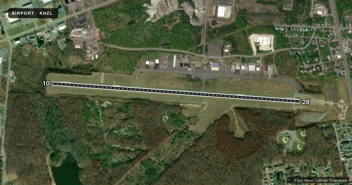
Runways & pattern
Full pagePattern entry · RWY 10
LEFT TRAFFICRunway end performance
| End | TORA | TODA | ASDA | LDA | VGSI | Approach lights | Obstruction |
|---|---|---|---|---|---|---|---|
| 10 | 5,001' | 5,001' | 5,001' | 4,801' | PAPI 4-box left(3.5°) | — | 221', trees, 5426' from thr, 183' R of cntrln, slope 23 |
| 28 | 5,001' | 5,001' | 5,001' | 4,898' | PAPI 4-box left(3.17°) | MALS | 45', tree, 1111' from thr, 97' R of cntrln, slope 20 |
Declared distances in feet. TORA = takeoff run available, TODA = takeoff distance, ASDA = accelerate-stop, LDA = landing distance.
Airport sketch
Runways drawn to scale from FAA survey coordinates, rendered over satellite imagery. Not for navigation.
Approaches & charts
ILS · 1
Services on the field
Fuel grades, oxygen, maintenance, ramp storage and lighting — as declared to the FAA by the airport operator.
Fuel & services
- Fuel
- 100LLA
- Oxygen (bottled)
- High pressure
- Oxygen (bulk)
- Not available
- Airframe repair
- Minor
- Power plant repair
- Minor
- Other services
- AMB,CHTR,PAJA
Ramp & ground
- Transient storage
- Tie-down
- Hangar
- Landing fee
- No fee published
- Customs
- Not available
- Lighting schedule
- SEE RMK
- Beacon schedule
- SS-SR
- Beacon
- White / Green (civil land)(WG)
- Wind indicator
- Lighted
- Segmented circle
- Yes
Fuel & FBOs
Cheapest 100LL and Jet A on the field and nearby. Always confirm with the FBO before taxi.
Airport notes
Surface conditions, obstructions, local procedures, lighting outages and other notes published with each FAA cycle.
General notes
- AWOS AVBL 570-459-4901.
- TYPE 1 AND 4 DEICING AVBL.
Lighting notes
- ACTVT MALS RWY 28; REIL RWY 10; PAPI RWY 10; MIRL RWY 10/28 (3,5,7 CLICKS) - CTAF.
Fuel notes
- 100LLFUEL SVC AFT HRS BY PRIOR REQ 570-468-2479.
Approach & departure obstructions
- 28VFR DEP PROCEDURE RIGHT TURN HEADING 300 DEGS AT END OF RY.
- 10RWY 10 APCH SLP 25:1 TO DTHR.
- 28RWY 28 APCH SLP 26:1 TO DTHR.
Other notes
- JET, TURBOPROP AND CORPORATE AIRCRAFT ONLY.
VFR map & nearby airports
VFR sectional. Tap any ICAO chip to open that airport.
Key facts · KHZL
Answer card- ICAO
- KHZL
- Name
- HAZLETON RGNL
- Location
- HAZLETON, PENNSYLVANIA
- Elevation
- 1,603.4 ft MSL
- Traffic pattern altitude
- 2,603.4 ft MSL (1,000 AGL)
- Control tower
- Non-towered (use CTAF)
- Total runways
- 1
- Longest runway
- 10/28 · 5,001 ft
- Published ILS approaches
- 1
- Published frequencies
- 5
- Magnetic variation
- 10°
- Current flight rules
- MVFR
- Current wind
- 000° at 0 kt
- Favored runway now
- –
Hazleton Rgnl is in Hazleton, Pennsylvania. The field elevation is 1,603.4 ft MSL. It has one runway, 10/28, which is 5,001 ft long. The airport is not towered. CTAF and UNICOM are both 123.0. Approach and departure service is handled by Wilkes-Barre on 126.3 or 256.7.
There is one ILS approach here. It serves runway 28. Pattern altitude is not published, so use the standard 1,000 ft AGL for light piston traffic unless the current Chart Supplement says otherwise. The on-field FBO is Hazleton Municipal Airport. It carries 100LL, Jet A and Jet A Prist. Call (570) 455-7641 for current service details.
A few published remarks matter for planning. Runway 28 has medium intensity approach lighting with sequenced flashers. Runway 10 has REIL and PAPI. The runway lights are pilot controlled through the CTAF with 3, 5 and 7 clicks. If you are departing runway 28 VFR, the published procedure calls for a right turn to heading 300 degrees at the end of the runway. The runway 10 and 28 approach slopes are noted as 25:1 and 26:1 to the displaced thresholds. Review the current Chart Supplement if you are planning a close-in approach. The field also publishes after-hours 100LL service by prior request. Deicing type 1 and 4 is available.