METAR & TAF KWBW
KWBW does not publish a METAR.
Showing the nearest reporting station: KAVP (WILKES-BARRE/SCRANTON INTL) · 6.3 NM away. Conditions at KWBW may differ.
METAR · KAVP
Observed 05:54Z
KAVP 270554Z 11005KT 10SM CLR 18/17 A2986 RMK AO2 SLP103 T01780167 10244 20178 58007
- Wind
- 110° @ 5 kt
- Visibility
- 10 SM
- Temp / Dew
- 18°C / 17°C
- Altimeter
- 29.86 inHg
- Clouds
- CLR
- Density alt
- 1,109 ft
- Ceiling
- Unlimited
- Rules
- VFR
Airport info & contacts
Manager on record, flight service, ARTCC, attendance schedule and pattern altitude — published by the FAA and refreshed every 28 days.
Location
- From city
- 3 NM N
- VFR sectional
- NEW YORK
- ARTCC
- ZNY · NEW YORK
- NOTAM facility
- IPT (NOTAM-D)
Airport manager
- Name
- JIM SCROBOLA
- Phone
- 570-288-3257
- Address
- 2001 WYOMING AVE, FORTY FORT PA 18704
Flight service · Hours
- FSS IPT
- WILLIAMSPORT1-800-WX-BRIEF
- Attendance
- 0800-1700
Frequencies
Tap any row to copy the frequency to your clipboard.
Runways & pattern
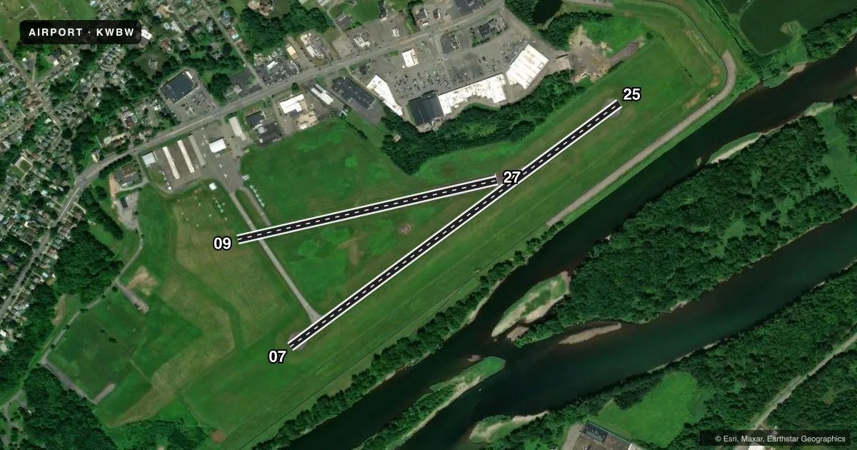
Full pagePattern entry · RWY 09
LEFT TRAFFIC| Runway | Heading (°M) | Length | Surface | Traffic |
|---|---|---|---|---|
| 07/25 | 42° / 222° | 3,375 ft | ASPH | Standard L |
| 09/27Favored | 65° / 245° | 2,193 ft | ASPH-TURF | Standard L |
Runway end performance
| End | TORA | TODA | ASDA | LDA | VGSI | Approach lights | Obstruction |
|---|---|---|---|---|---|---|---|
| 07 | — | — | — | — | PAPI 2-box left(4°) | — | — |
| 25 | — | — | — | — | PAPI 2-box left(3.75°) | — | 120', tree, 2286' from thr, 528' R of cntrln, slope 17 |
| 09 | — | — | — | — | — | — | 94', trees, 1107' from thr, 136' R of cntrln, slope 11 |
Declared distances in feet. TORA = takeoff run available, TODA = takeoff distance, ASDA = accelerate-stop, LDA = landing distance.
Airport sketch
Runways drawn to scale from FAA survey coordinates, rendered over satellite imagery. Not for navigation.
Approaches & charts
Services on the field
Fuel grades, oxygen, maintenance, ramp storage and lighting — as declared to the FAA by the airport operator.
Fuel & services
- Fuel
- 100LLA
- Oxygen (bottled)
- Not available
- Oxygen (bulk)
- Not available
- Airframe repair
- Major
- Power plant repair
- Major
- Other services
- AFRT,AGRI,INSTR,RNTL
Ramp & ground
- Transient storage
- Tie-down
- Hangar
- Landing fee
- No fee published
- Customs
- Not available
- Lighting schedule
- SEE RMK
- Beacon schedule
- SEE RMK
- Beacon
- White / Green (civil land)(WG)
- Wind indicator
- Yes
- Segmented circle
- Yes
Fuel & FBOs
Cheapest 100LL and Jet A on the field and nearby. Always confirm with the FBO before taxi.
Airport notes
Surface conditions, obstructions, local procedures, lighting outages and other notes published with each FAA cycle.
General notes
- +152 FT TRANSMISSION LINES 6000 FT FROM RWY 25 THLD 585 FT L MKD WITH RED SPHERES.
- FOR CD CTC WILKES-BARRE APCH AT 570-655-2084.
Lighting notes
- ACTVT ROTG BCN - CTAF.
- ACTVT PAPI RWY 07/25; MIRL RWY 07/25 - CTAF. RWY 07/25 PRESET LOW INTST TO ACTVT HIGHER INTST - CTAF.
Runway surface & condition
- 09/27RWY 09/27 CLSD WINTER MONTHS.
- 09/27RWY 09/27 FIRST 544 FT RWY 27 ASPH, RMNDR TURF.
Approach & departure obstructions
- 09RWY 09/27 MKD WITH 3 FT WHITE CONES. RWY 09; DSPLCD THLD MKD WITH THREE WHITE CONES EACH SIDE.
- 09APCH RATIO 18:1 TO DTHR.
Other notes
- EXISTED PRIOR TO 1959.
VFR map & nearby airports
VFR sectional. Tap any ICAO chip to open that airport.
Key facts · KWBW
Answer card- ICAO
- KWBW
- Name
- WILKES-BARRE WYOMING VALLEY
- Location
- WILKES-BARRE, PENNSYLVANIA
- Elevation
- 543.8 ft MSL
- Traffic pattern altitude
- 1,543.8 ft MSL (1,000 AGL)
- Control tower
- Non-towered (use CTAF)
- Total runways
- 2
- Longest runway
- 07/25 · 3,375 ft
- Published ILS approaches
- 0
- Published frequencies
- 4
- Magnetic variation
- 12°
- Current flight rules
- VFR
- Current wind
- 110° at 5 kt
- Favored runway now
- RWY 09
Wilkes-Barre Wyoming Valley Airport sits in Wilkes-Barre, Pennsylvania. Field elevation is 543.8 ft MSL. The airport has two runways. The longest is 07/25 at 3,375 ft. There is no control tower. Pattern altitude is not published, so use the standard 1,000 ft AGL for light piston operations unless the current Chart Supplement says otherwise.
No ILS approaches are published here. The field is served by Valley Aviation on the field. They carry 100LL and Jet A. CTAF and UNICOM are both 122.8. The rotating beacon is activated by CTAF. Runway 07/25 lighting is also CTAF activated. It is preset to low intensity and can be raised by CTAF.
A few items matter on a first visit. Runway 09/27 is marked with cones. Its 09 displaced threshold is also marked with cones. The first 544 feet of runway 27 is paved. The rest is turf. Runway 09/27 is closed during winter months. There are +152 ft transmission lines 6,000 ft from the runway 25 threshold, 585 ft left, with red spheres. For clearance delivery, contact Wilkes-Barre Approach on 570-655-2084. If you need current noise, curfew, or operating details, check the current FAA Chart Supplement before you go.