METAR & TAF 48P
48P does not publish a METAR.
Showing the nearest reporting station: KMPO (POCONO MOUNTAINS RGNL) · 4.8 NM away. Conditions at 48P may differ.
METAR · KMPO
Observed 04:53Z
KMPO 260453Z AUTO 00000KT 10SM 14/11 A3003 RMK AO2 SLP163 T01390111 402390100
- Wind
- 000° @ 0 kt
- Visibility
- 10 SM
- Temp / Dew
- 14°C / 11°C
- Altimeter
- 30.03 inHg
- Clouds
- Clear
- Density alt
- 1,281 ft
- Ceiling
- Unlimited
- Rules
- VFR
Airport info & contacts
Manager on record, flight service, ARTCC, attendance schedule and pattern altitude — published by the FAA and refreshed every 28 days.
Location
- From city
- 1 NM SE
- VFR sectional
- NEW YORK
- ARTCC
- ZNY · NEW YORK
- NOTAM facility
- IPT (NOTAM-D)
Airport manager
- Name
- CHARLENE A. BARRY
- Phone
- 570-595-2269
- Address
- 174 QUARRY LN., CRESCO PA 18326
Flight service · Hours
- FSS IPT
- WILLIAMSPORT1-800-WX-BRIEF
- Attendance
- Unattended
Frequencies
Tap any row to copy the frequency to your clipboard.
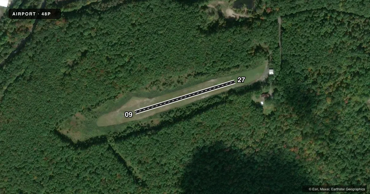
Runways & pattern
Full pagePattern entry · RWY 09
LEFT TRAFFICRunway end performance
| End | TORA | TODA | ASDA | LDA | VGSI | Approach lights | Obstruction |
|---|---|---|---|---|---|---|---|
| 09 | — | — | — | — | — | — | 62', trees, 674' from thr, 70' R of cntrln, slope 10 |
| 27 | — | — | — | — | — | — | 49', trees, 579' from thr, 0' R of cntrln, slope 11 |
Declared distances in feet. TORA = takeoff run available, TODA = takeoff distance, ASDA = accelerate-stop, LDA = landing distance.
Airport sketch
Runways drawn to scale from FAA survey coordinates, rendered over satellite imagery. Not for navigation.
Approaches & charts
Services on the field
Fuel grades, oxygen, maintenance, ramp storage and lighting — as declared to the FAA by the airport operator.
Fuel & services
- Fuel
- Not available
Ramp & ground
- Transient storage
- Not published
- Wind indicator
- Yes
Fuel & FBOs
Cheapest 100LL and Jet A on the field and nearby. Always confirm with the FBO before taxi.
Airport notes
Surface conditions, obstructions, local procedures, lighting outages and other notes published with each FAA cycle.
General notes
- DEER & WILDLIFE ON & INVOF ARPT.
- ANNOUNCE TFC ON CTAF 122.9.
- FOR CD CTC ALLENTOWN APCH AT 800-728-6322.
Approach & departure obstructions
- 09APCH SLP 13:1 TO DTHR.
- 27APCH SLOPE 14:1 TO 80 FT DTHR.
Other notes
- PRVDD DAYLGT VFR OPNS; A CLEAR 20:1 APCH/DEP PATH; OPERATE IN A MANNER TO MINIMIZE NOISE; AND LOA W/MOCENT POCONO MUNI ARPT COORDINATING ALL ACTIVITIES.
VFR map & nearby airports
VFR sectional. Tap any ICAO chip to open that airport.
Key facts · 48P
Answer card- ICAO
- 48P
- Name
- ROCKY HILL
- Location
- CRESCO, PENNSYLVANIA
- Elevation
- 1,240 ft MSL
- Traffic pattern altitude
- 2,240 ft MSL (1,000 AGL)
- Control tower
- Non-towered (use CTAF)
- Total runways
- 1
- Longest runway
- 09/27 · 1,000 ft
- Published ILS approaches
- 0
- Published frequencies
- 0
- Magnetic variation
- –
- Current flight rules
- VFR
- Current wind
- 000° at 0 kt
- Favored runway now
- –
Rocky Hill (48P) sits in Cresco, Pennsylvania at 1,240 ft MSL. It has one runway. Runway 09/27 is 1,000 ft of turf. The airport is not towered. Pattern altitude is not published, so use the standard 1,000 ft AGL for light piston traffic. That puts the pattern at 2,240 ft MSL.
No ILS approaches are published here. The field is set up for daylight VFR use. Published remarks call for a clear 20 to 1 approach and departure path. They also say operations should minimize noise. A letter of agreement with MOCENT Pocono Municipal Airport coordinates all activities. The approach to runway 09 rises 13 to 1 up to the threshold. The approach to runway 27 rises 14 to 1 for the first 80 ft from the threshold. Deer and other wildlife are reported on and near the airport.
There are no on-field FBOs listed. Plan on self-sufficiency. CTAF traffic calls are on 122.9. For clearance delivery, contact Allentown Approach at 800-728-6322. If you are new to the strip, pay close attention to the short turf runway. Watch the obstruction notes. Keep wildlife in mind.