METAR & TAF N30
N30 does not publish a METAR.
Showing the nearest reporting station: KMSV (SULLIVAN COUNTY INTL) · 23.3 NM away. Conditions at N30 may differ.
METAR · KMSV
Observed 09:56Z
KMSV 270956Z AUTO 35004KT 6SM BR CLR 16/15 A2987 RMK AO2 SLP107 T01560150 PNO $
- Wind
- 350° @ 4 kt
- Visibility
- 6 SM
- Temp / Dew
- 16°C / 15°C
- Altimeter
- 29.87 inHg
- Clouds
- CLR
- Density alt
- 1,865 ft
- Ceiling
- Unlimited
- Rules
- VFR
Airport info & contacts
Manager on record, flight service, ARTCC, attendance schedule and pattern altitude — published by the FAA and refreshed every 28 days.
Location
- From city
- 3 NM S
- VFR sectional
- NEW YORK
- ARTCC
- ZNY · NEW YORK
- NOTAM facility
- IPT (NOTAM-D)
Airport manager
- Name
- RICHARD QUITONI
- Phone
- 570-253-5833
- Address
- 30 BOMBER LANE, HONESDALE PA 18431
Flight service · Hours
- FSS IPT
- WILLIAMSPORT1-800-WX-BRIEF
- Attendance
- 0900-1700
Frequencies
Tap any row to copy the frequency to your clipboard.
Runways & pattern
Full pagePattern entry · RWY 36
LEFT TRAFFICRunway end performance
| End | TORA | TODA | ASDA | LDA | VGSI | Approach lights | Obstruction |
|---|---|---|---|---|---|---|---|
| 18 | — | — | — | — | — | — | 84', tree, 1270' from thr, 224' R of cntrln, slope 12 |
| 36 | — | — | — | — | — | — | 51', tree, 259' from thr, 110' R of cntrln, slope 1 |
Declared distances in feet. TORA = takeoff run available, TODA = takeoff distance, ASDA = accelerate-stop, LDA = landing distance.
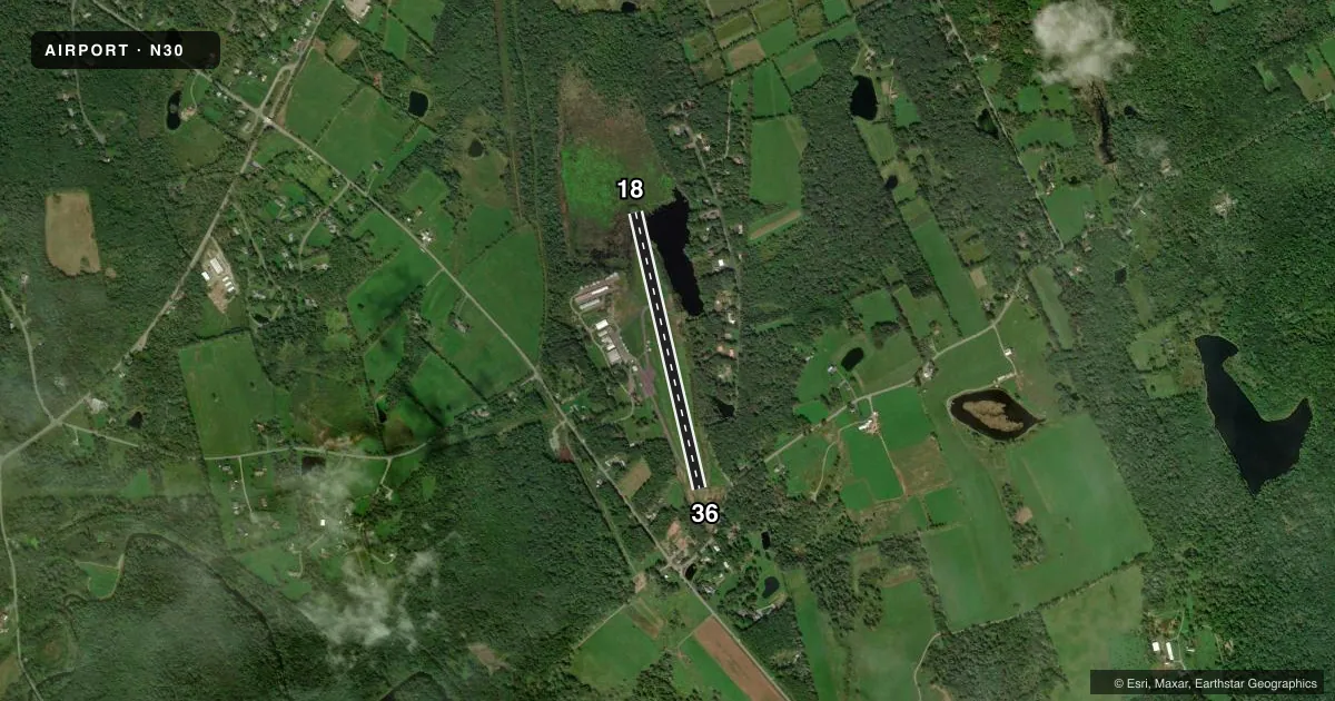
Airport sketch
Runways drawn to scale from FAA survey coordinates, rendered over satellite imagery. Not for navigation.
Approaches & charts
Services on the field
Fuel grades, oxygen, maintenance, ramp storage and lighting — as declared to the FAA by the airport operator.
Fuel & services
- Fuel
- 100LL
- Oxygen (bottled)
- Not available
- Oxygen (bulk)
- Not available
- Airframe repair
- Major
- Power plant repair
- Major
- Other services
- INSTR,RNTL
Ramp & ground
- Transient storage
- Tie-down
- Hangar
- Landing fee
- No fee published
- Customs
- Not available
- Lighting schedule
- SS-SR
- Beacon schedule
- SS-SR
- Beacon
- White / Green (civil land)(WG)
- Wind indicator
- Lighted
- Segmented circle
- No
Fuel & FBOs
Cheapest 100LL and Jet A on the field and nearby. Always confirm with the FBO before taxi.
Airport notes
Surface conditions, obstructions, local procedures, lighting outages and other notes published with each FAA cycle.
General notes
- FOR CD CTC WILKES-BARRE APCH AT 570-655-2084.
Approach & departure obstructions
- 18APCH RATIO 21:1 TO DTHR.
- 36APCH RATIO 17:1 TO DTHR.
VFR map & nearby airports
VFR sectional. Tap any ICAO chip to open that airport.
Key facts · N30
Answer card- ICAO
- N30
- Name
- CHERRY RIDGE
- Location
- HONESDALE, PENNSYLVANIA
- Elevation
- 1,357 ft MSL
- Traffic pattern altitude
- 2,357 ft MSL (1,000 AGL)
- Control tower
- Non-towered (use CTAF)
- Total runways
- 1
- Longest runway
- 18/36 · 2,986 ft
- Published ILS approaches
- 0
- Published frequencies
- 4
- Magnetic variation
- 13°
- Current flight rules
- VFR
- Current wind
- 350° at 4 kt
- Favored runway now
- RWY 36
Cherry Ridge is in Honesdale, Pennsylvania. Field elevation is 1,357 ft MSL. The airport has one runway, 18/36, which is 2,986 ft long and asphalt. There is no control tower. Clearance delivery is handled by Wilkes-Barre Approach at 570-655-2084. The published pattern altitude is not listed, so use the current Chart Supplement before you fly. For light piston traffic, standard pattern planning would be 1,000 ft AGL unless the current published data says otherwise.
No ILS approaches are published here. That matters if you are planning an IFR arrival in lower weather. The field sits in a higher-elevation part of Pennsylvania. Performance planning should account for density altitude, runway length and the displaced-threshold obstacle notes on both ends. The published remarks call out approach ratios to the displaced thresholds on runway 36 and runway 18. Review those before arrival.
Earlynn Aviation is on the field. It carries 100LL. CTAF and UNICOM are both 122.8. With one runway and no tower, expect self-announce traffic and keep your scan tight in the pattern. Check the current Chart Supplement for any additional local procedures before you go.