METAR & TAF 76N
76N does not publish a METAR.
Showing the nearest reporting station: KAVP (WILKES-BARRE/SCRANTON INTL) · 15.2 NM away. Conditions at 76N may differ.
METAR · KAVP
Observed 10:54Z
KAVP 271054Z 00000KT 10SM CLR 16/15 A2988 RMK AO2 SLP112 T01610150
- Wind
- 000° @ 0 kt
- Visibility
- 10 SM
- Temp / Dew
- 16°C / 15°C
- Altimeter
- 29.88 inHg
- Clouds
- CLR
- Density alt
- 962 ft
- Ceiling
- Unlimited
- Rules
- VFR
Airport info & contacts
Manager on record, flight service, ARTCC, attendance schedule and pattern altitude — published by the FAA and refreshed every 28 days.
Location
- From city
- 1 NM S
- VFR sectional
- NEW YORK
- ARTCC
- ZNY · NEW YORK
- NOTAM facility
- IPT (NOTAM-D)
Airport manager
- Name
- CHARLIE GAY
- Phone
- 570-466-0697
- Address
- 626 HUNTER HWY, TUNKHANNOCK PA 18657
Flight service · Hours
- FSS IPT
- WILLIAMSPORT1-800-WX-BRIEF
- Attendance
- 0800-DUSK
Frequencies
Tap any row to copy the frequency to your clipboard.
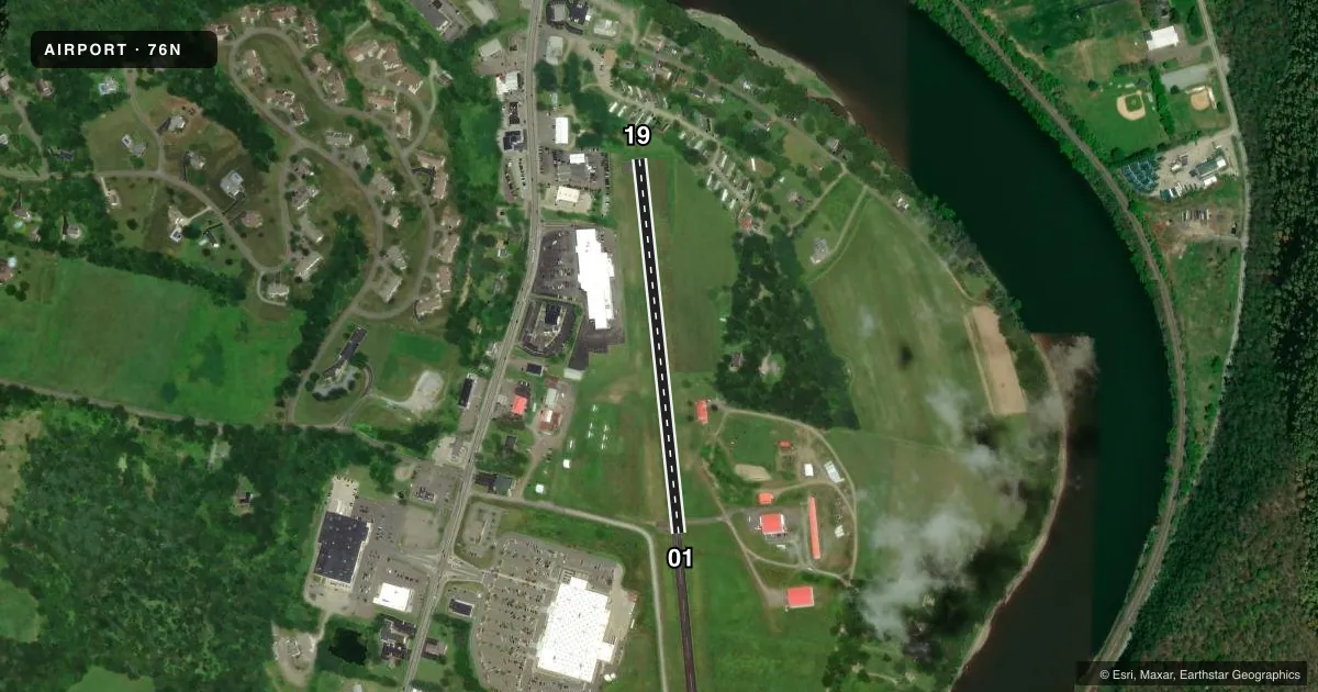
Runways & pattern
Full pagePattern entry · RWY 01
LEFT TRAFFICRunway end performance
| End | TORA | TODA | ASDA | LDA | VGSI | Approach lights | Obstruction |
|---|---|---|---|---|---|---|---|
| 19 | — | — | — | — | — | — | 41', trees, 217' from thr, 101' R of cntrln, slope 0 |
Declared distances in feet. TORA = takeoff run available, TODA = takeoff distance, ASDA = accelerate-stop, LDA = landing distance.
Airport sketch
Runways drawn to scale from FAA survey coordinates, rendered over satellite imagery. Not for navigation.
Approaches & charts
Services on the field
Fuel grades, oxygen, maintenance, ramp storage and lighting — as declared to the FAA by the airport operator.
Fuel & services
- Fuel
- 100LL
- Oxygen (bottled)
- Not available
- Oxygen (bulk)
- Not available
- Airframe repair
- Major
- Power plant repair
- Major
- Other services
- AGRI,SURV
Ramp & ground
- Transient storage
- Tie-down
- Hangar
- Landing fee
- No fee published
- Wind indicator
- Yes
- Segmented circle
- Yes
Fuel & FBOs
Cheapest 100LL and Jet A on the field and nearby. Always confirm with the FBO before taxi.
Airport notes
Surface conditions, obstructions, local procedures, lighting outages and other notes published with each FAA cycle.
General notes
- FOR CD CTC WILKES-BARRE APCH AT 570-655-2084.
Approach & departure obstructions
- 19APCH SLP 15:1 TO DTHR. CTLG OBSTN EXCEEDS A 45 DEG SLP.
Other notes
- EXISTED PRIOR TO 1959
- 1FOR SVC AFTER HRS PHONE 570-466-0697/570-362-4169/570-836-3884.
VFR map & nearby airports
VFR sectional. Tap any ICAO chip to open that airport.
Key facts · 76N
Answer card- ICAO
- 76N
- Name
- SKYHAVEN
- Location
- TUNKHANNOCK, PENNSYLVANIA
- Elevation
- 639 ft MSL
- Traffic pattern altitude
- 1,639 ft MSL (1,000 AGL)
- Control tower
- Non-towered (use CTAF)
- Total runways
- 1
- Longest runway
- 01/19 · 2,007 ft
- Published ILS approaches
- 0
- Published frequencies
- 4
- Magnetic variation
- 12°
- Current flight rules
- VFR
- Current wind
- 000° at 0 kt
- Favored runway now
- –
Skyhaven (76N) sits in Tunkhannock, Pennsylvania. Field elevation is 639 ft MSL. The airport has one asphalt runway, 01/19, at 2,007 ft. There is no control tower. CTAF and UNICOM are both 122.8. No ILS approaches are published here.
Pattern altitude is not published. Use 1,000 ft AGL for light piston operations unless the current Chart Supplement says otherwise. That puts the standard pattern near 1,639 ft MSL. The airport uses Wilkes-Barre Approach for clearance delivery and approach or departure services. Clearance delivery is handled on 570-655-2084.
Skyhaven Inc is the on-field FBO. It carries 100LL. For service after hours, the published remarks list several phone numbers for contact. The remarks also note an obstacle issue near runway 19. The approach slope to the displaced threshold is 15 to 1. A cataloged obstruction exceeds a 45 degree slope. That makes a careful look at runway 19 and the departure path a good idea before you go.
This is a small, non-towered field with one short runway. Check the current FAA Chart Supplement for any changes to pattern work, runway condition, or local procedures before flight.