METAR & TAF 12N
Current METAR
Observed 07:54Z
K12N 270754Z AUTO 00000KT 18/17 A2984 RMK AO1 SLP096 T01830167 $
- Wind
- 000° @ 0 kt
- Visibility
- —
- Temp / Dew
- 18°C / 17°C
- Altimeter
- 29.84 inHg
- Clouds
- Clear
- Density alt
- 1,182 ft
- Ceiling
- Unlimited
- Rules
- VFR
Airport info & contacts
Manager on record, flight service, ARTCC, attendance schedule and pattern altitude — published by the FAA and refreshed every 28 days.
Location
- From city
- 3 NM N
- VFR sectional
- NEW YORK
- ARTCC
- ZNY · NEW YORK
- NOTAM facility
- 12N (NOTAM-D)
Airport manager
- Name
- ERIC D. WEBER
- Phone
- 973-786-6350
- Address
- AEROFLEX-ANDOVER ARPT, P.O. BOX 709, ANDOVER NJ 07821
Flight service · Hours
- FSS MIV
- MILLVILLE1-800-WX-BRIEF
- Attendance
- TUE - SUN · 0900-1700
Frequencies
Tap any row to copy the frequency to your clipboard.
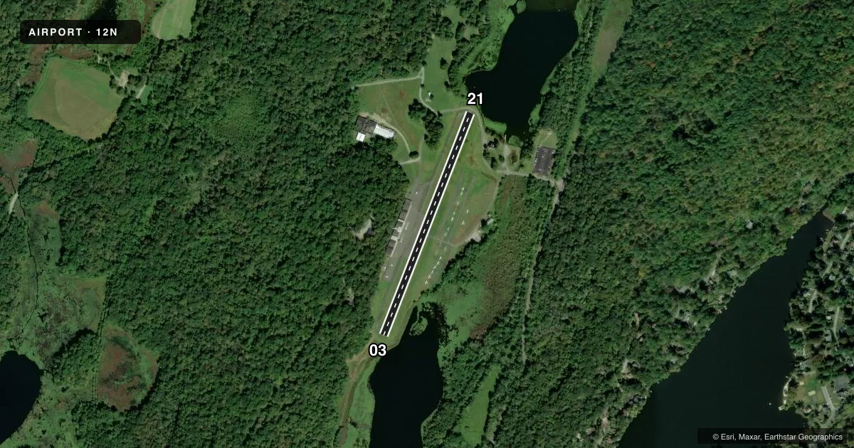
Runways & pattern
Full pagePattern entry · RWY 03
RIGHT TRAFFICRunway end performance
| End | TORA | TODA | ASDA | LDA | VGSI | Approach lights | Obstruction |
|---|---|---|---|---|---|---|---|
| 03 | — | — | — | — | — | — | 108', trees, 504' from thr, 256' R of cntrln, slope 2 |
| 21 | — | — | — | — | — | — | 64', tree, 580' from thr, 150' R of cntrln, slope 5 |
Declared distances in feet. TORA = takeoff run available, TODA = takeoff distance, ASDA = accelerate-stop, LDA = landing distance.
Airport sketch
Runways drawn to scale from FAA survey coordinates, rendered over satellite imagery. Not for navigation.
Approaches & charts
Services on the field
Fuel grades, oxygen, maintenance, ramp storage and lighting — as declared to the FAA by the airport operator.
Fuel & services
- Fuel
- 100LL
- Oxygen (bottled)
- Not available
- Oxygen (bulk)
- Not available
- Airframe repair
- Major
- Power plant repair
- Major
- Other services
- INSTR
Ramp & ground
- Transient storage
- Tie-down
- Landing fee
- No fee published
- Customs
- Not available
- Lighting schedule
- SEE RMK
- Beacon schedule
- SS-SR
- Beacon
- White / Green (civil land)(WG)
- Wind indicator
- Lighted
- Segmented circle
- Yes
Fuel & FBOs
Cheapest 100LL and Jet A on the field and nearby. Always confirm with the FBO before taxi.
Airport notes
Surface conditions, obstructions, local procedures, lighting outages and other notes published with each FAA cycle.
General notes
- DIRT SVC ROAD TO TRML AREA IN FRONT OF RWY 03 THLD.
- PARALLEL TURF RWY RESTRICTED USE ONLY.
- ARPT RESTRICTED TO APCH CATAGORY A ACFT ONLY.
- NO TGL.
- RY 03/21 LAKES AT BOTH APCH ENDS.
- NOISE ABATEMENT PROCEDURES IN EFFECT. CTC AMGR 973-786-6350.
- PPR REQUIRED FOR NIGHT TRANSIENTS CTC AMGR 973-786-5100.
- AVOID OVERFLYING LAKE LENAPE WHILE ON DOWNWIND.
- FOR CD CTC NEWARK APCH AT 800-645-3206.
- DEER & BIRDS ON & INVOF ARPT.
Lighting notes
- ACTVT MIRL RWY 03/21 - CTAF.
Approach & departure obstructions
- 03RWY 03 80 FT TREE AT RWY END 167 FT LEFT OF CNTRLN.
- 21RY 21 15 FT ROAD AT THLD.
Other notes
- THIS AIRPORT HAS BEEN SURVEYED BY THE NATIONAL GEODETIC SURVEY.
VFR map & nearby airports
VFR sectional. Tap any ICAO chip to open that airport.
Key facts · 12N
Answer card- ICAO
- 12N
- Name
- AEROFLEX/ANDOVER
- Location
- ANDOVER, NEW JERSEY
- Elevation
- 582.7 ft MSL
- Traffic pattern altitude
- 1,582.7 ft MSL (1,000 AGL)
- Control tower
- Non-towered (use CTAF)
- Total runways
- 1
- Longest runway
- 03/21 · 1,981 ft
- Published ILS approaches
- 0
- Published frequencies
- 4
- Magnetic variation
- 13°
- Current flight rules
- VFR
- Current wind
- 000° at 0 kt
- Favored runway now
- –
AEROFLEX/ANDOVER (12N) is in Andover, New Jersey. The field elevation is 582.7 ft MSL. It has one runway, 03/21, which is 1,981 ft long. There is no control tower. Pattern altitude is not published. Use the standard 1,000 ft AGL pattern for light piston operations unless the current Chart Supplement says otherwise.
No ILS approaches are published here. Newark Approach handles approach and departure services on 123.775 and 379.9. CTAF and UNICOM are both 122.8. The airport is restricted to approach category A aircraft only. That matters here because the runway is short and there are lakes at both ends of 03/21. Runway 03 has an 80-foot tree near the departure end, 167 feet left of centerline. Runway 21 has a 15-foot road at the threshold. Deer and birds are reported on and near the airport.
Aeroflex-Andover Airport is the on-field FBO. Fuel grades are not reported in the facts, so call ahead at (973) 786-5100 for current service details. Medium intensity runway lights on 03/21 are activated by CTAF. Night transient operations need prior permission from the airport manager. Avoid overflying Lake Lenape on downwind. There are no touch-and-go operations.