METAR & TAF KSMQ
Current METAR
Observed 11:53Z
KSMQ 271153Z AUTO 00000KT 7SM CLR 20/18 A2983 RMK AO2 SLP101 T02000178 10200 20172 53010
- Wind
- 000° @ 0 kt
- Visibility
- 7 SM
- Temp / Dew
- 20°C / 18°C
- Altimeter
- 29.83 inHg
- Clouds
- CLR
- Density alt
- 843 ft
- Ceiling
- Unlimited
- Rules
- VFR
Airport info & contacts
Manager on record, flight service, ARTCC, attendance schedule and pattern altitude — published by the FAA and refreshed every 28 days.
Location
- From city
- 3 NM N
- VFR sectional
- NEW YORK
- ARTCC
- ZNY · NEW YORK
- NOTAM facility
- SMQ (NOTAM-D)
Airport manager
- Name
- CHRIS WALKER, PRES.
- Phone
- 908-722-2444
- Address
- PO BOX 1007, BEDMINSTER NJ 07921
Flight service · Hours
- FSS MIV
- MILLVILLE1-800-WX-BRIEF
- Attendance
- 0800-1700
Frequencies
Tap any row to copy the frequency to your clipboard.
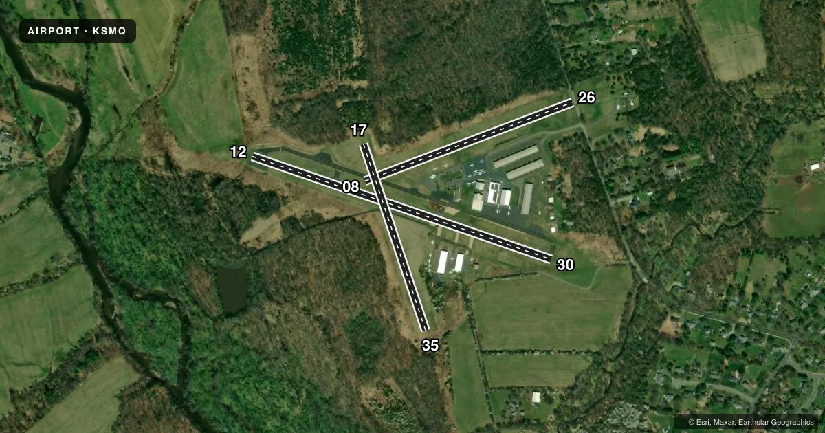
Runways & pattern
Full pagePattern entry · RWY 12
LEFT TRAFFIC| Runway | Heading (°M) | Length | Surface | Traffic |
|---|---|---|---|---|
| 12/30 | 96° / 276° | 2,739 ft | ASPH | Standard L |
| 08/26 | 56° / 236° | 1,923 ft | TURF | 26 R |
| 17/35 | 148° / 328° | 1,700 ft | TURF | Standard L |
Runway end performance
| End | TORA | TODA | ASDA | LDA | VGSI | Approach lights | Obstruction |
|---|---|---|---|---|---|---|---|
| 12 | — | — | — | — | PAPI 2-box right(3°) | — | 55', trees, 587' from thr, 163' R of cntrln, slope 7 |
| 30 | — | — | — | — | PAPI 2-box left(4°) | — | 65', trees, 795' from thr, 280' R of cntrln, slope 9 |
| 08 | — | — | — | — | — | — | 51', tree, 200' from thr, 50' R of cntrln, slope 3 |
| 26 | — | — | — | — | — | — | 45', tree, 10' from thr, 140' R of cntrln, slope 0 |
| 17 | — | — | — | — | — | — | 65', trees, 20' from thr, 120' R of cntrln, slope 0 |
| 35 | — | — | — | — | — | — | 22', trees, 10' from thr, 90' R of cntrln, slope 0 |
Declared distances in feet. TORA = takeoff run available, TODA = takeoff distance, ASDA = accelerate-stop, LDA = landing distance.
Airport sketch
Runways drawn to scale from FAA survey coordinates, rendered over satellite imagery. Not for navigation.
Approaches & charts
Services on the field
Fuel grades, oxygen, maintenance, ramp storage and lighting — as declared to the FAA by the airport operator.
Fuel & services
- Fuel
- 100LLA
- Oxygen (bottled)
- HIGH/LOW
- Oxygen (bulk)
- HIGH/LOW
- Airframe repair
- Major
- Power plant repair
- Major
- Other services
- AMB,AVNCS,CHTR,INSTR,RNTL,SALES
Ramp & ground
- Transient storage
- Tie-down
- Hangar
- Landing fee
- No fee published
- Customs
- Not available
- Lighting schedule
- SEE RMK
- Beacon schedule
- SS-SR
- Beacon
- White / Green (civil land)(WG)
- Wind indicator
- Lighted
- Segmented circle
- No
Fuel & FBOs
Cheapest 100LL and Jet A on the field and nearby. Always confirm with the FBO before taxi.
Airport notes
Surface conditions, obstructions, local procedures, lighting outages and other notes published with each FAA cycle.
General notes
- DEER AND BIRDS ON AND INVOF ARPT
- NO TGL.
- FOR CD CTC NEWARK APCH AT 800-645-3206.
Lighting notes
- ACTVT REIL RWY 12 & 30; PAPI RWY 12 & 30; MIRL RWY 12/30 - 118.325.
Runway surface & condition
- 08/26550 FT W END UNSUITABLE FOR TKOF OR LDG DUE TO UNEVEN SFC.
Approach & departure obstructions
- 30APCH RATIO 15:1 TO DTHR.
Other notes
- EST 1946.
- 1UNATTENDED THANKSGIVING, CHRISTMAS & NEW YEARS.
VFR map & nearby airports
VFR sectional. Tap any ICAO chip to open that airport.
Key facts · KSMQ
Answer card- ICAO
- KSMQ
- Name
- SOMERSET
- Location
- SOMERVILLE, NEW JERSEY
- Elevation
- 106.2 ft MSL
- Traffic pattern altitude
- 1,106.2 ft MSL (1,000 AGL)
- Control tower
- Non-towered (use CTAF)
- Total runways
- 3
- Longest runway
- 12/30 · 2,739 ft
- Published ILS approaches
- 0
- Published frequencies
- 4
- Magnetic variation
- 13°
- Current flight rules
- VFR
- Current wind
- 000° at 0 kt
- Favored runway now
- –
Somerset Airport (KSMQ) sits in Somerville, New Jersey. Field elevation is 106.2 ft MSL. It has three runways. The longest is runway 12/30 at 2,739 ft asphalt. The airport is not towered. Newark Approach handles clearance delivery. Published approach frequencies are 132.8 and 379.9. CTAF and UNICOM are both 123.0.
No ILS approaches are published here. Pattern altitude is not published, so verify the current pattern entry and traffic flow before you go. For light piston traffic, plan on the standard 1,000 ft AGL unless the current Chart Supplement or the airport operator says otherwise. Somerset Air Service is on the field. It carries 100LL, Jet A and Jet A Prist. Runway 12/30 has medium intensity lights, PAPI and runway end identifier lights. The lighting frequency is 118.325.
A few operational notes matter here. No touch-and-go operations are permitted. The west 550 ft of runway 08/26 is unsuitable for takeoff or landing because of an uneven surface. Deer and birds are reported on and near the airport. Runway 30 also has a displaced-threshold approach slope note in the published remarks. If you are planning a night arrival or a first visit, review the current Chart Supplement and brief the runway lighting and runway-use notes before departure.