METAR & TAF 47N
47N does not publish a METAR.
Showing the nearest reporting station: KSMQ (SOMERSET) · 6.9 NM away. Conditions at 47N may differ.
METAR · KSMQ
Observed 06:53Z
KSMQ 270653Z AUTO 00000KT 8SM OVC110 18/17 A2981 RMK AO2 SLP094 T01780167
- Wind
- 000° @ 0 kt
- Visibility
- 8 SM
- Temp / Dew
- 18°C / 17°C
- Altimeter
- 29.81 inHg
- Clouds
- OVC
- Density alt
- 603 ft
- Ceiling
- 11,000 ft AGL
- Rules
- VFR
Airport info & contacts
Manager on record, flight service, ARTCC, attendance schedule and pattern altitude — published by the FAA and refreshed every 28 days.
Location
- From city
- 1 NM S
- VFR sectional
- NEW YORK
- ARTCC
- ZNY · NEW YORK
- NOTAM facility
- MIV (NOTAM-D)
Airport manager
- Name
- TERRI AND JOSEPH HORNER
- Phone
- 908-526-2822
- Address
- PO BOX 358, MANVILLE NJ 08835
Flight service · Hours
- FSS MIV
- MILLVILLE1-800-WX-BRIEF
- Attendance
- 0800-DUSK
Frequencies
Tap any row to copy the frequency to your clipboard.
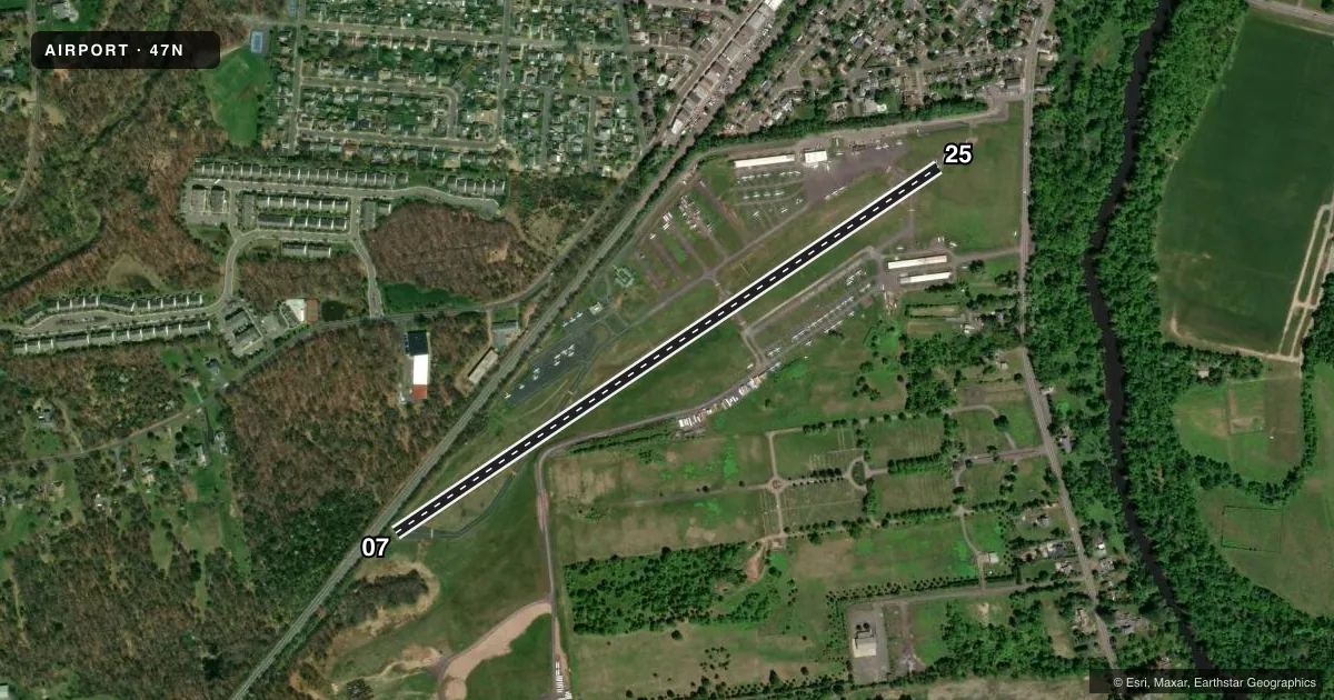
Runways & pattern
Full pagePattern entry · RWY 07
LEFT TRAFFICRunway end performance
| End | TORA | TODA | ASDA | LDA | VGSI | Approach lights | Obstruction |
|---|---|---|---|---|---|---|---|
| 07 | — | — | — | — | PAPI 2-box left(3.4°) | — | 23', rr, 200' from thr, 0' R of cntrln, slope 0 |
| 25 | — | — | — | — | PAPI 2-box left(3.3°) | — | 31', trees, 558' from thr, 0' R of cntrln, slope 11 |
Declared distances in feet. TORA = takeoff run available, TODA = takeoff distance, ASDA = accelerate-stop, LDA = landing distance.
Airport sketch
Runways drawn to scale from FAA survey coordinates, rendered over satellite imagery. Not for navigation.
Approaches & charts
Services on the field
Fuel grades, oxygen, maintenance, ramp storage and lighting — as declared to the FAA by the airport operator.
Fuel & services
- Fuel
- 100LL
- Oxygen (bottled)
- Not available
- Oxygen (bulk)
- Not available
- Airframe repair
- Major
- Power plant repair
- Major
- Other services
- GLD,INSTR,RNTL
Ramp & ground
- Transient storage
- Tie-down
- Hangar
- Landing fee
- No fee published
- Customs
- Not available
- Beacon schedule
- SS-SR
- Beacon
- White / Green (civil land)(WG)
- Wind indicator
- Lighted
- Segmented circle
- No
Fuel & FBOs
Cheapest 100LL and Jet A on the field and nearby. Always confirm with the FBO before taxi.
Airport notes
Surface conditions, obstructions, local procedures, lighting outages and other notes published with each FAA cycle.
General notes
- FOR CD CTC NEWARK APCH AT 800-645-3206.
- BANNER TOW OPS SW RWY 07.
- DEER & BIRDS ON & INVOF ARPT.
Approach & departure obstructions
- 07FENCE 10 FT ADJACENT TO RR TRACK L OF RWY.
- 25+42 FT TREE 128 FT FROM RWY END 220 FT R.
Other notes
- EXISTED PRIOR TO 1959.
- 1EXCEPT FOR CHRISTMAS & NEW YEAR.
VFR map & nearby airports
VFR sectional. Tap any ICAO chip to open that airport.
Key facts · 47N
Answer card- ICAO
- 47N
- Name
- CENTRAL JERSEY RGNL
- Location
- MANVILLE, NEW JERSEY
- Elevation
- 85.9 ft MSL
- Traffic pattern altitude
- 1,085.9 ft MSL (1,000 AGL)
- Control tower
- Non-towered (use CTAF)
- Total runways
- 1
- Longest runway
- 07/25 · 3,507 ft
- Published ILS approaches
- 0
- Published frequencies
- 4
- Magnetic variation
- 13°
- Current flight rules
- VFR
- Current wind
- 000° at 0 kt
- Favored runway now
- –
Central Jersey Rgnl is in Manville, New Jersey. The field elevation is 85.9 ft MSL. It has one runway. Runway 07/25 is 3,507 ft long with an asphalt surface. There is no control tower. Clearance delivery goes through Newark Approach. The published approach frequencies are 132.8 and 379.9. No ILS approaches are published here.
The pattern altitude is not published. Use the standard 1,000 ft AGL for light piston operations unless the current Chart Supplement says otherwise. Central Jersey Airport Services is on the field. It carries 100LL. Call (908) 526-2822 for current service details before you go.
A few runway details matter here. There is a 42-foot tree near the departure end of runway 25, 128 feet from the end and 220 feet right of centerline. There is also a 10-foot fence near the railroad track left of runway 07. Banner tow operations occur southwest of runway 07. Deer and birds are reported on and near the airport, so keep a sharp scan in the pattern and on taxi. The airport is attended daily except Christmas and New Year. For any current noise, curfew, or local operating limits, check the current FAA Chart Supplement before flying in.