METAR & TAF 3N6
3N6 does not publish a METAR.
Showing the nearest reporting station: KBLM (MONMOUTH EXEC) · 13.3 NM away. Conditions at 3N6 may differ.
METAR · KBLM
Observed 00:29Z
KBLM 040029Z AUTO 34031G43KT 6SM VCTS HZ SQ SCT075 BKN120 34/19 A2998 RMK AO2 PK WND 33043/0027 LTG DSNT W-NE TSB29 PRESRR PNO $
- Wind
- 340° @ 31G43 kt
- Visibility
- 6 SM
- Temp / Dew
- 34°C / 19°C
- Altimeter
- 29.98 inHg
- Clouds
- BKN
- Density alt
- 2,313 ft
- Ceiling
- 12,000 ft AGL
- Rules
- VFR
Airport info & contacts
Manager on record, flight service, ARTCC, attendance schedule and pattern altitude — published by the FAA and refreshed every 28 days.
Location
- From city
- 5 NM S
- VFR sectional
- NEW YORK
- ARTCC
- ZNY · NEW YORK
- NOTAM facility
- MIV (NOTAM-D)
Airport manager
- Name
- PAUL CERNIGLIA
- Phone
- 732-718-0444
- Address
- 182 PENSION RD, ENGLISHTOWN NJ 07726
Flight service · Hours
- FSS MIV
- MILLVILLE1-800-WX-BRIEF
- Attendance
- 0800-1700
Frequencies
Tap any row to copy the frequency to your clipboard.
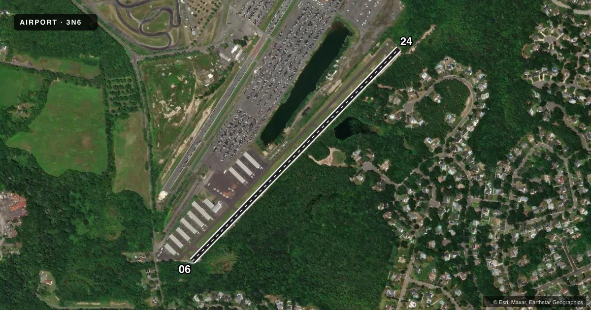
Runways & pattern
Full pagePattern entry · RWY 06
LEFT TRAFFICRunway end performance
| End | TORA | TODA | ASDA | LDA | VGSI | Approach lights | Obstruction |
|---|---|---|---|---|---|---|---|
| 06 | — | — | — | — | PAPI 2-box left(4°) | — | 80', tree, 280' from thr, 200' R of cntrln, slope 1 |
| 24 | — | — | — | — | PAPI 2-box right(4°) | — | 40', tree, 400' from thr, 135' R of cntrln, slope 5 |
Declared distances in feet. TORA = takeoff run available, TODA = takeoff distance, ASDA = accelerate-stop, LDA = landing distance.
Airport sketch
Runways drawn to scale from FAA survey coordinates, rendered over satellite imagery. Not for navigation.
Approaches & charts
Services on the field
Fuel grades, oxygen, maintenance, ramp storage and lighting — as declared to the FAA by the airport operator.
Fuel & services
- Fuel
- 100LL
- Oxygen (bottled)
- Not available
- Oxygen (bulk)
- Not available
- Airframe repair
- Major
- Power plant repair
- Major
- Other services
- INSTR,RNTL
Ramp & ground
- Transient storage
- Tie-down
- Lighting schedule
- SEE RMK
- Beacon schedule
- SEE RMK
- Beacon
- White / Green (civil land)(WG)
- Wind indicator
- Lighted
- Segmented circle
- Yes
Fuel & FBOs
Cheapest 100LL and Jet A on the field and nearby. Always confirm with the FBO before taxi.
Airport notes
Surface conditions, obstructions, local procedures, lighting outages and other notes published with each FAA cycle.
General notes
- NO TOUCH & GO.
- GCO AVBL ON FREQ 121.725 THRU MIV RADIO.
- DRAG STRIP PARK & TREES E/W OF ARPT & INVOF APCH END RWY 6/24.
- FOR CD USE GCO 121.725, IF UNABLE CTC MC GUIRE APCH AT 609-754-2767.
- DEER & BIRDS ON & INVOF ARPT.
- TWYS FAIR COND, 2 IN CRACKS, 2 TO 3 IN DEEP, NEAR TWY HOLD SHORT LINES. TWY SFCS UNEVEN. ALL TWY MKGS FADED.
Lighting notes
- ACTVT ROTG BCN - CTAF.
- ACTVT REIL RWY 6 & 24; MIRL RWY 06/24 - CTAF.
Approach & departure obstructions
- 0616 FT HNGR 53 FT FROM RWY END 200 FT L OF CNTRLN; 25 FT TREELINE 125 FT FROM RWY END ACRS CNTRLN.
- 06APCH SLOPE 11:1 TO DSPLCD THLD.
- 24APCH SLOPE 20:1 TO DSPLCD THLD.
Other notes
- THIS AIRPORT HAS BEEN SURVEYED BY THE NATIONAL GEODETIC SURVEY.
- PVDD R TFC PAT TO RWY 24.
VFR map & nearby airports
VFR sectional. Tap any ICAO chip to open that airport.
Key facts · 3N6
Answer card- ICAO
- 3N6
- Name
- OLD BRIDGE
- Location
- OLD BRIDGE, NEW JERSEY
- Elevation
- 87 ft MSL
- Traffic pattern altitude
- 1,087 ft MSL (1,000 AGL)
- Control tower
- Non-towered (use CTAF)
- Total runways
- 1
- Longest runway
- 06/24 · 3,594 ft
- Published ILS approaches
- 0
- Published frequencies
- 4
- Magnetic variation
- 13°
- Current flight rules
- VFR
- Current wind
- 340° at 31 kt
- Favored runway now
- RWY 06
Old Bridge Airport sits in Old Bridge, New Jersey. Field elevation is 87 ft MSL. The airport has one runway. Runway 06/24 is 3,594 ft long and asphalt. No ILS approaches are published here. The field is non-towered. Published pattern altitude is not listed, so verify the current pattern in the FAA Chart Supplement before you fly in. For a light piston, the usual assumption is 1,000 ft AGL unless the current published data says otherwise.
Old Bridge Airport has one on-field FBO. Old Bridge Airport carries 100LL. Call (732) 446-0303 for current service details. The remarks also note CTAF-activated lighting, including the rotating beacon, runway end identifier lights and medium intensity runway lights on 06/24. Clearance delivery can be handled through the ground communications outlet on 121.725. If that does not work, McGuire Approach is the backup contact.
A few items matter here for a first visit. Right traffic is published for runway 24. There are obstructions near the runway 06 end. The airport also has deer and birds in the area. Taxiways are reported in fair condition with cracks, uneven surfaces and faded markings. Check the current Chart Supplement before departure for any updated pattern, lighting, or operational notes.