METAR & TAF KBLM
Current METAR
Observed 00:29Z
KBLM 040029Z AUTO 34031G43KT 6SM VCTS HZ SQ SCT075 BKN120 34/19 A2998 RMK AO2 PK WND 33043/0027 LTG DSNT W-NE TSB29 PRESRR PNO $
- Wind
- 340° @ 31G43 kt
- Visibility
- 6 SM
- Temp / Dew
- 34°C / 19°C
- Altimeter
- 29.98 inHg
- Clouds
- BKN
- Density alt
- 2,396 ft
- Ceiling
- 12,000 ft AGL
- Rules
- VFR
Airport info & contacts
Manager on record, flight service, ARTCC, attendance schedule and pattern altitude — published by the FAA and refreshed every 28 days.
Location
- From city
- 5 NM W
- VFR sectional
- NEW YORK
- ARTCC
- ZNY · NEW YORK
- NOTAM facility
- BLM (NOTAM-D)
Airport manager
- Name
- ALAN ANTAKI
- Phone
- 732-751-0044
- Address
- 1717 STATE RD 34, BLDG 5, FARMINGDALE NJ 07727
Flight service · Hours
- FSS MIV
- MILLVILLE1-800-WX-BRIEF
- Attendance
- ALL
Frequencies
Tap any row to copy the frequency to your clipboard.
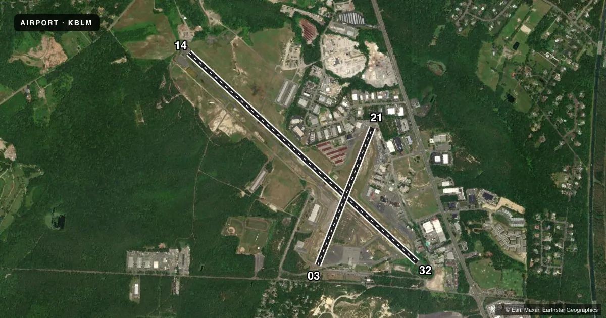
Runways & pattern
Full pagePattern entry · RWY 32
LEFT TRAFFIC| Runway | Heading (°M) | Length | Surface | Traffic |
|---|---|---|---|---|
| 14/32Favored | 120° / 300° | 7,345 ft | ASPH | Standard L |
| 03/21 | 10° / 190° | 3,508 ft | ASPH | Standard L |
Runway end performance
| End | TORA | TODA | ASDA | LDA | VGSI | Approach lights | Obstruction |
|---|---|---|---|---|---|---|---|
| 14 | — | — | — | — | — | — | 30', trees, 807' from thr, 243' R of cntrln, slope 20 |
| 32 | — | — | — | — | — | — | 27', trees, 774' from thr, 0' R of cntrln, slope 20 |
| 03 | — | — | — | — | — | — | 43', trees, 473' from thr, 0' R of cntrln, slope 6 |
| 21 | — | — | — | — | — | — | 29', tree, 210' from thr, 75' R of cntrln, slope 0 |
Declared distances in feet. TORA = takeoff run available, TODA = takeoff distance, ASDA = accelerate-stop, LDA = landing distance.
Airport sketch
Runways drawn to scale from FAA survey coordinates, rendered over satellite imagery. Not for navigation.
Approaches & charts
Services on the field
Fuel grades, oxygen, maintenance, ramp storage and lighting — as declared to the FAA by the airport operator.
Fuel & services
- Fuel
- 100LLA
- Oxygen (bottled)
- Not available
- Oxygen (bulk)
- Not available
- Airframe repair
- Minor
- Power plant repair
- Minor
- Other services
- CHTR,INSTR,RNTL
Ramp & ground
- Transient storage
- Tie-down
- Hangar
- Landing fee
- Yes
- Customs
- Not available
- Lighting schedule
- SS-SR
- Beacon schedule
- SS-SR
- Beacon
- White / Green (civil land)(WG)
- Wind indicator
- Lighted
- Segmented circle
- No
Fuel & FBOs
Cheapest 100LL and Jet A on the field and nearby. Always confirm with the FBO before taxi.
Airport notes
Surface conditions, obstructions, local procedures, lighting outages and other notes published with each FAA cycle.
General notes
- NO TOUCH & GO LANDINGS FRI; SAT; SUN.
- DEER & BIRDS ON & INVOF ARPT.
- RY 14/32 NON-STD TWY SEPARATION 185 FT.
- BERM 36 FT HIGH; NORTH RY 14/32 65 FT FROM CNTRLN.
- TWYS NSTD MARKINGS. RY HOLD MARKINGS ON TWYS NSTD PLACEMENT. TWY LINES DO NOT ENSURE WING TIP/ROTOR CLEARANCE AT NW END OF PARALLEL TWY.
- NO HELICOPTER ACTIVITY NE OF RY 14. HELICOPTER INSTRUCTION BY PRE-ARRANGEMENT ONLY 732-938-4800.
- FOR CD CTC MC GUIRE APCH VIA FREQ, IF UNA CALL 609-754-2767.
- ALL TSNT ACFT MUST GO TO FBO ON WEST SIDE OF ARPT.
Fuel notes
- 100LLSELF-SVC 100LL AVABL 24 HRS.
- AJET A AVBL 24 HRS.
Runway surface & condition
- 03/21RWY 03/21 CLSD TO ACFT OVER 12500 LBS.
- 14/32RWY 14/32 NSTD MIRLS; RWY 32 THLD LGTS NTSD.
- 14/32RWY 14/32 FIRST 575 FT AT AER 32 85 FT WIDE; REMAINDER RWY 14/32 100 FT WIDE
Approach & departure obstructions
- 03+15 FT TREE 138 FT FM RWY END 13 FT R CNTRLN.
- 21RWY 21 32 FT POLE/BLDG 60 FT FROM THLD, 70 FT LEFT.
- 14OBSTN CLNC SLOPE 20:1 TO THRESHOLD
- 32OBSTN CLNC SLOPE 20:1 TO THRESHOLD
Other notes
- ARPT ESTAB 1938.
VFR map & nearby airports
VFR sectional. Tap any ICAO chip to open that airport.
Key facts · KBLM
Answer card- ICAO
- KBLM
- Name
- MONMOUTH EXEC
- Location
- BELMAR/FARMINGDALE, NEW JERSEY
- Elevation
- 153.4 ft MSL
- Traffic pattern altitude
- 1,153.4 ft MSL (1,000 AGL)
- Control tower
- Non-towered (use CTAF)
- Total runways
- 2
- Longest runway
- 14/32 · 7,345 ft
- Published ILS approaches
- 0
- Published frequencies
- 5
- Magnetic variation
- 12°
- Current flight rules
- VFR
- Current wind
- 340° at 31 kt
- Favored runway now
- RWY 32
Monmouth Exec sits in Belmar/Farmingdale, New Jersey. Field elevation is 153.4 ft MSL. The airport has two asphalt runways. The longest is 14/32 at 7,345 ft. Runway 03/21 is 3,508 ft. There is no control tower. CTAF and UNICOM are both 123.0. Approach and departure services are on McGuire frequencies.
No ILS approaches are published here. Pattern altitude is not published, so use standard traffic pattern planning unless the current FAA Chart Supplement says otherwise. Monmouth Jet Center is on the field. It carries 100LL, JET A and JET A PRIST. Self-service 100LL is available 24 hours.
This field has several operational notes that matter on a first visit. Runway 14/32 has non-standard taxiway separation and non-standard markings. Hold markings are also non-standard in places. Taxi lines do not guarantee wingtip or rotor clearance at the northwest end of the parallel taxiway. Runway 21 has a pole or building near the threshold. Runway 03 has a tree near the departure end. Runway 03/21 is closed to aircraft over 12,500 pounds. No touch-and-go landings are permitted on Friday, Saturday, or Sunday. Helicopter instruction is by prior arrangement only. Check the current FAA Chart Supplement for any noise or curfew restrictions before flying in.