METAR & TAF KLDJ
Current METAR
Observed 06:35Z
KLDJ 270635Z AUTO 00000KT 10SM OVC110 23/16 A2983 RMK AO2 T02250155
- Wind
- 000° @ 0 kt
- Visibility
- 10 SM
- Temp / Dew
- 23°C / 16°C
- Altimeter
- 29.83 inHg
- Clouds
- OVC
- Density alt
- 1,099 ft
- Ceiling
- 11,000 ft AGL
- Rules
- VFR
Airport info & contacts
Manager on record, flight service, ARTCC, attendance schedule and pattern altitude — published by the FAA and refreshed every 28 days.
Location
- From city
- 1 NM SE
- VFR sectional
- NEW YORK
- ARTCC
- ZNY · NEW YORK
- NOTAM facility
- MIV (NOTAM-D)
Airport manager
- Name
- PAUL DUDLEY
- Phone
- 908-862-5557
- Address
- 1101 WEST EDGAR RD, LINDEN NJ 07036
Flight service · Hours
- FSS MIV
- MILLVILLE1-800-WX-BRIEF
- Attendance
- OCT-APR · 0830-1800
- MAY-SEP · 0700-2030
Frequencies
Tap any row to copy the frequency to your clipboard.
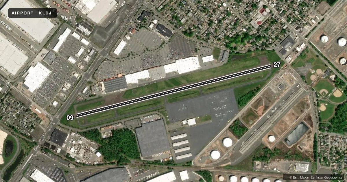
Runways & pattern
Full pagePattern entry · RWY 09
LEFT TRAFFICRunway end performance
| End | TORA | TODA | ASDA | LDA | VGSI | Approach lights | Obstruction |
|---|---|---|---|---|---|---|---|
| 09 | — | — | — | — | VASI 2-box right(3.8°) | — | 32', pole, 352' from thr, 30' R of cntrln, slope 4 |
| 27 | — | — | — | — | VASI 2-box left(3.5°) | — | 47', ant, 554' from thr, 100' R of cntrln, slope 7 |
Declared distances in feet. TORA = takeoff run available, TODA = takeoff distance, ASDA = accelerate-stop, LDA = landing distance.
Airport sketch
Runways drawn to scale from FAA survey coordinates, rendered over satellite imagery. Not for navigation.
Approaches & charts
Services on the field
Fuel grades, oxygen, maintenance, ramp storage and lighting — as declared to the FAA by the airport operator.
Fuel & services
- Fuel
- 100LLA
- Oxygen (bottled)
- Not available
- Oxygen (bulk)
- Not available
- Airframe repair
- Minor
- Power plant repair
- Minor
- Other services
- CHTR,INSTR,RNTL,SALES
Ramp & ground
- Transient storage
- Tie-down
- Hangar
- Landing fee
- Yes
- Customs
- Not available
- Lighting schedule
- SEE RMK
- Beacon schedule
- SS-SR
- Beacon
- White / Green (civil land)(WG)
- Wind indicator
- Lighted
- Segmented circle
- Yes
Fuel & FBOs
Cheapest 100LL and Jet A on the field and nearby. Always confirm with the FBO before taxi.
Airport notes
Surface conditions, obstructions, local procedures, lighting outages and other notes published with each FAA cycle.
General notes
- TPA 800 FT MSL; RY 9 ENTER TFC PAT UPWIND - ENTRIES OTR RYS STD.
- DEPG RY 27 DEP STRAIGHT OUT TO 800 FT.
- NOISE ABATEMENT PROCEDURES IN EFFECT.
- TOUCH & GO LANDINGS FOR BASE ASSIGNED ACFT; ALL OTHERS CTC AMGR (908) 862-8800 FOR PPR.
- RY 09/27 RWY SHOULDER MARKINGS NSTD.
- MAIN NORTH TWY CLSD INDEFLY.
- DEER & BIRDS ON & INVOF APRT.
- FOR CD CTC NEWARK TWR ON 127.25 OR CTC NEWARK APCH AT 800-645-3206.
Lighting notes
- ACTVT MIRL RY 09/27; VASI RYS 09 & 27; AND REILS RYS 09 & 27- CTAF.
Approach & departure obstructions
- 09VASI UNUSBL BYD 6 DEGS RIGHT AND LEFT OF CNTRLN.
- 27VASI UNUSBL BYD 2 DEGS RIGHT OF CNTRLN.
- 09APCH RATIO 25:1 TO DSPLCD THLD BASED ON 32 FT POLE 812 FT FM DSPLCD THLD.
- 27APCH RATIO 23:1 TO DTHR BASED ON 47 FT ANT 1097 FT FM DTHR.
VFR map & nearby airports
VFR sectional. Tap any ICAO chip to open that airport.
Key facts · KLDJ
Answer card- ICAO
- KLDJ
- Name
- LINDEN
- Location
- LINDEN, NEW JERSEY
- Elevation
- 22 ft MSL
- Traffic pattern altitude
- 1,022 ft MSL (1,000 AGL)
- Control tower
- Non-towered (use CTAF)
- Total runways
- 1
- Longest runway
- 09/27 · 4,140 ft
- Published ILS approaches
- 0
- Published frequencies
- 6
- Magnetic variation
- 13°
- Current flight rules
- VFR
- Current wind
- 000° at 0 kt
- Favored runway now
- –
Linden Airport is in Linden, New Jersey. The field elevation is 22 ft MSL. It has one runway, 09/27, which is 4,140 ft long. There is no control tower. For clearance delivery, Newark tower is listed on 127.25. Newark approach is also listed on 128.55. No ILS approaches are published here.
The published traffic pattern altitude is 800 ft MSL. For runway 09, enter the pattern on the upwind leg. Other entries are standard. Noise abatement procedures are in effect. That matters here because this is a busy metro-area field with Newark procedures in the mix. Touch-and-goes are only permitted for base assigned aircraft. All other aircraft need prior permission from the airport manager.
Linden Air Services is on the field. It carries 100LL and Jet A. Runway 09/27 has medium intensity lights. VASI is available on both ends. The runway end identifier lights are on CTAF. One operational note stands out. The main north taxiway is closed indefinitely. Runway 27 also has a published straight-out departure to 800 ft. The runway shoulder markings are not standard, so brief the pavement layout before taxi.