METAR & TAF KEWR
Current METAR
Observed 09:51Z
KEWR 270951Z 22004KT 10SM FEW070 BKN120 BKN250 22/17 A2982 RMK AO2 SLP096 T02170167 $
- Wind
- 220° @ 4 kt
- Visibility
- 10 SM
- Temp / Dew
- 22°C / 17°C
- Altimeter
- 29.82 inHg
- Clouds
- BKN
- Density alt
- 986 ft
- Ceiling
- 12,000 ft AGL
- Rules
- VFR
Airport info & contacts
Manager on record, flight service, ARTCC, attendance schedule and pattern altitude — published by the FAA and refreshed every 28 days.
Location
- From city
- 3 NM S
- VFR sectional
- NEW YORK
- ARTCC
- ZNY · NEW YORK
- NOTAM facility
- EWR (NOTAM-D)
Airport manager
- Name
- FRANK RADICS
- Phone
- 973-961-6161
- Address
- BUILDING #1- CONRAD ROAD, NEWARK NJ 07114
Flight service · Hours
- FSS ISP
- NEW YORK1-800-WX-BRIEF
- Attendance
- ALL
Frequencies
Tap any row to copy the frequency to your clipboard.
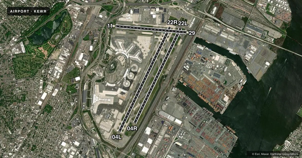
Runways & pattern
Full pagePattern entry · RWY 22R
LEFT TRAFFIC| Runway | Heading (°M) | Length | Surface | Traffic |
|---|---|---|---|---|
| 04L/22RFavored | 13° / 193° | 11,000 ft | ASPH-CONC | Standard L |
| 04R/22L | 13° / 193° | 9,999 ft | ASPH | Standard L |
| 11/29 | 82° / 262° | 6,725 ft | ASPH | Standard L |
Runway end performance
| End | TORA | TODA | ASDA | LDA | VGSI | Approach lights | Obstruction |
|---|---|---|---|---|---|---|---|
| 04L | 11,000' | 11,000' | 11,000' | 8,459' | PAPI 4-box left(3.1°) | MALSR | 65', tree, 1926' from thr, 572' R of cntrln, slope 26 |
| 22R | 11,000' | 11,000' | 11,000' | 9,559' | PAPI 4-box left(3.1°) | MALSR | 28', pole, 295' from thr, 477' R of cntrln, slope 3 |
| 04R | 9,999' | 9,999' | 9,999' | 8,809' | PAPI 4-box left(2.95°) | ALSF2 | 28', pole, 953' from thr, 600' R of cntrln, slope 26 |
| 22L | 9,999' | 9,999' | 9,999' | 8,205' | PAPI 4-box left(3°) | ALSF2 | 30', ant, 540' from thr, 534' R of cntrln, slope 11 |
| 11 | 6,725' | 6,725' | 6,725' | 6,725' | PAPI 4-box right(3°) | — | 158', bldg, 6197' from thr, 1437' R of cntrln, slope 37 |
| 29 | 6,725' | 6,725' | 6,725' | 6,501' | PAPI 4-box right(3°) | — | 54', sign, 818' from thr, 514' R of cntrln, slope 11 |
Declared distances in feet. TORA = takeoff run available, TODA = takeoff distance, ASDA = accelerate-stop, LDA = landing distance.
Airport sketch
Runways drawn to scale from FAA survey coordinates, rendered over satellite imagery. Not for navigation.
Approaches & charts
ILS · 5
Services on the field
Fuel grades, oxygen, maintenance, ramp storage and lighting — as declared to the FAA by the airport operator.
Fuel & services
- Fuel
- 100LLA
- Oxygen (bottled)
- High pressure
- Airframe repair
- Major
- Power plant repair
- Major
- Other services
- AFRT,CARGO
Ramp & ground
- Transient storage
- Hangar
- Landing fee
- Yes
- Customs
- Not available
- Beacon schedule
- SS-SR
- Beacon
- White / Green (civil land)(WG)
- Wind indicator
- Lighted
- Segmented circle
- No
Fuel & FBOs
Cheapest 100LL and Jet A on the field and nearby. Always confirm with the FBO before taxi.
Airport notes
Surface conditions, obstructions, local procedures, lighting outages and other notes published with each FAA cycle.
General notes
- FLOCKS OF BIRDS ON & INVOF ARPT.
- NOISE RSTR CALL 212-435-3784 DRG NML BUS HRS.
- PARA-SAIL & BANNER TOWING OPS 1000 FT & BLO IN UPPER & LOWER NY BAYS INCLUDING ROCKAWAY INLET INDEF.
- TWY Z BTN TWY Z2 & Z4 CLSD TO ACFT WITH WINGSPANS IN EXCESS OF 171 FT.
- RWY 4R & 4L DEP USE UPPER ANT FOR ATC COM.
- HIGH VOLUME OF LOW LEVEL HEL TFC ARR AND DEP HELO KEARNY HELI (65NJ) LCTD 3.5 MILES NE OF ARPT.
- RWY STATUS LIGHTS IN OPR.
- CPDLC DEPARTURE CLEARANCE SERVICE AVAILABLE.
- ADG IV ACFT RSTR FM PSG TWY Z3 ON Z.
- TWY Z EAST OF TWY U ACFT SPEED RSTR OF 17 KTS/20 MPH MAX FOR ALL ACFT WITH WINGSPANS IN EXCESS OF 171 FT.
- ALL TWYS SURROUNDING "BALLPARK" PRKG AREA (TWY Y BTN TWY S AND TWY U, TWY S BTN TWY Y AND TWY K, TWAY K BTN TWY S AND TWY B, TWY B BTN TWY K AND TWY U, AND TWY U BTN TWY B AND TWY Y) ACFT SPEED RSTR OF 17KTS/20MPH FOR ALL AFCT WITH WINGSPANS IN EXCESS OF 171 FT.
- TWY EE BTN RWY 4R-22L AND RWY 11-29 CLSD TO AFCT WITH WINGSPANS IN EXCESS OF 171 FT.
- TWY Y BTN RM AND TWY U, SPEED RESTRICTION OF 17KT (20MPH).
- TWY Z5 CLSD TO ACFT WITH WINGSPANS IN EXCESS OF 118 FT.
- TWY A BTN TWY AA AND RAMP CLSD TO ACFT WITH WINGSPANS IN EXCESS OF 171 FT.
- TWY A11 W OF TWY A ACFT SPD RSTR OF 17 KTS/20 MPH MAX FOR ALL ACFT WITH WINGSPANS IN EXCESS OF 171 FT.
- ACFT WITH WINGSPANS IN EXCESS OF 118 FEET PROHIBITED FROM TURNING S ON TWY R FROM TWY B1.
- DURNG ATC ZERO EVENTS; ARPT OPS WILL MNT 118.3 AND PROVIDE EMERG NOTIFICATIONS TO ARFF.
- WHEN RWY 04R/L IN USE, ACFT PRKG AT TRML A CAN EXP TO ENTER RAMP VIA TWY A8, UNLESS ADZD BY ATC.
- WHEN RWY 22L/R IN USE, ACFT PRKG AT TRML A CAN EXP TO ENTER RAMP VIA TWY A10 OR A12, UNLESS ADZD BY ATC.
Runway surface & condition
- 04L/22RPCR VALUE: 960/F/C/X/T
- 04R/22LPCR VALUE: 1020/F/C/X/T
- 11/29PCR VALUE: 950/F/C/X/T
- H1BREWSTER PAD; H1 LCTD ON TWY Z5. OPS LIMITS ARE D65.
Approach & departure obstructions
- 04R+5 FT POLE 25 FT FROM RWY END 175 FT RIGHT.
- 29PAPI UNUSBL 4 DEGS LEFT OF CNTRLN.
- 04LAPCH RATIO 50:1 TO DTHR.
- 04RAPCH RATIO 50:1 TO DTHR.
- 22LAPCH RATIO 50:1 TO DTHR.
- 22RAPCH RATIO 50:1 TO DTHR.
- 29APCH RATIO 13:1 TO DTHR.
Arresting gear
- 11_EMASENGINEERED MATERIALS ARRESTING SYSTEM (EMAS) 182 FT IN LENGTH BY 170 FT IN WIDTH LCTD AT THE DER.
- 29_EMASENGINEERED MATERIALS ARRESTING SYSTEM (EMAS) 437 FT IN LENGTH BY 178 FT IN WIDTH LCTD AT THE DER.
Other notes
- GA/INTRNT LDG FEES PAYABLE BY MAJOR CREDIT CARDS ONLY.
- OWNERPROPERTY OWNED BY CITY OF NEWARK.
- 04L/22RS 1779 FT CONC, N 1228 FT CONC, CENTER 7993 FT ASPH.
VFR map & nearby airports
VFR sectional. Tap any ICAO chip to open that airport.
Key facts · KEWR
Answer card- ICAO
- KEWR
- Name
- NEWARK LIBERTY INTL
- Location
- NEWARK, NEW JERSEY
- Elevation
- 17.5 ft MSL
- Traffic pattern altitude
- 1,017.5 ft MSL (1,000 AGL)
- Control tower
- Towered · 24
- Total runways
- 3
- Longest runway
- 04L/22R · 11,000 ft
- Published ILS approaches
- 5
- Published frequencies
- 24
- Magnetic variation
- 13°
- Current flight rules
- VFR
- Current wind
- 220° at 4 kt
- Favored runway now
- RWY 22R
Newark Liberty Intl is in Newark, New Jersey. The field elevation is 17.5 ft MSL. KEWR has 3 runways. The longest is 11,000 ft on 04L/22R. The airport is towered. The control tower is open 24 hours. Five ILS approaches are published for runway ends 04L, 04R, 11, 22L and 22R.
Pattern altitude is not published in the facts. Use the current FAA Chart Supplement before you fly. The airport sits in the New York metro area. Expect a busy Class B environment. Plan for close ATC coordination. The published remarks also matter. Taxiway limits apply to aircraft with wingspans over 171 feet. There is also an EMAS bed at a runway departure end. Runway 04R has a nearby pole off the end. Review the current chart and taxi instructions carefully.
Signature Aviation is on the field. It carries 100LL and Jet A. If you are new to KEWR, get the latest airport notes from the current FAA Chart Supplement. Be ready for heavy traffic flow and tight ground handling. This is not a place to guess at pattern work or taxi routing.