METAR & TAF KCDW
Current METAR
Observed 11:53Z
KCDW 271153Z 00000KT 10SM CLR 22/17 A2984 RMK AO2 SLP109 T02220172 10222 20200 52009
- Wind
- 000° @ 0 kt
- Visibility
- 10 SM
- Temp / Dew
- 22°C / 17°C
- Altimeter
- 29.84 inHg
- Clouds
- CLR
- Density alt
- 1,153 ft
- Ceiling
- Unlimited
- Rules
- VFR
Airport info & contacts
Manager on record, flight service, ARTCC, attendance schedule and pattern altitude — published by the FAA and refreshed every 28 days.
Location
- From city
- 2 NM N
- VFR sectional
- NEW YORK
- ARTCC
- ZNY · NEW YORK
- NOTAM facility
- CDW (NOTAM-D)
Airport manager
- Name
- JOE CALI
- Phone
- 973-227-4567
- Address
- 27 WRIGHT WAY, FAIRFIELD NJ 07004
Flight service · Hours
- FSS MIV
- MILLVILLE1-800-WX-BRIEF
- Attendance
- 0700-2300
Frequencies
Tap any row to copy the frequency to your clipboard.
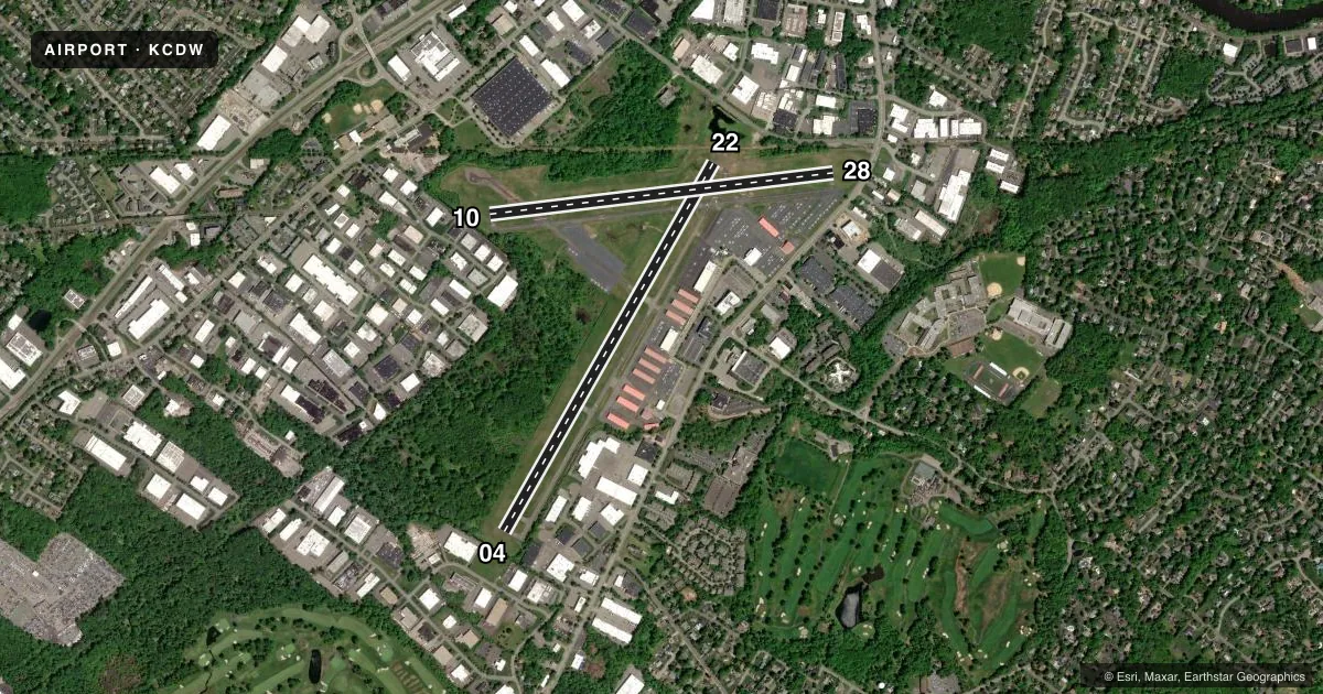
Runways & pattern
Full pagePattern entry · RWY 04
LEFT TRAFFIC| Runway | Heading (°M) | Length | Surface | Traffic |
|---|---|---|---|---|
| 04/22 | 17° / 197° | 4,552 ft | ASPH | 22 R |
| 10/28 | 70° / 250° | 3,719 ft | ASPH | 28 R |
Runway end performance
| End | TORA | TODA | ASDA | LDA | VGSI | Approach lights | Obstruction |
|---|---|---|---|---|---|---|---|
| 04 | 4,552' | 4,552' | 4,351' | 3,977' | — | — | 45', tree, 220' from thr, 137' R of cntrln, slope 0 |
| 22 | 4,552' | 4,552' | 4,436' | 4,042' | PAPI 4-box right(3.1°) | — | 90', trees, 400' from thr, 245' R of cntrln, slope 2 |
| 10 | 3,719' | 3,719' | 3,519' | 2,822' | — | — | 39', tree, 264' from thr, 0' R of cntrln, slope 1 |
| 28 | 3,719' | 3,719' | 3,438' | 2,822' | — | — | 46', tree, 423' from thr, 123' R of cntrln, slope 4 |
Declared distances in feet. TORA = takeoff run available, TODA = takeoff distance, ASDA = accelerate-stop, LDA = landing distance.
Airport sketch
Runways drawn to scale from FAA survey coordinates, rendered over satellite imagery. Not for navigation.
Approaches & charts
ILS · 1
Services on the field
Fuel grades, oxygen, maintenance, ramp storage and lighting — as declared to the FAA by the airport operator.
Fuel & services
- Fuel
- 100LLA
- Oxygen (bottled)
- Low pressure
- Oxygen (bulk)
- Not available
- Airframe repair
- Major
- Power plant repair
- Major
- Other services
- AVNCS,CHTR,INSTR,RNTL,SALES
Ramp & ground
- Transient storage
- Tie-down
- Hangar
- Landing fee
- Yes
- Customs
- Not available
- Lighting schedule
- SEE RMK
- Beacon schedule
- SS-SR
- Beacon
- White / Green (civil land)(WG)
- Wind indicator
- Lighted
- Segmented circle
- No
Fuel & FBOs
Cheapest 100LL and Jet A on the field and nearby. Always confirm with the FBO before taxi.
Airport notes
Surface conditions, obstructions, local procedures, lighting outages and other notes published with each FAA cycle.
General notes
- LCL OPNS SUSPENDED FROM 2300-0700 MON THRU SAT 2300 SAT UNTIL 1000 SUN.
- FIXED WING VFR ACFT DEP: RWY 4 - FLY RWY HDG FOR 1 MI, THEN TURN CROSSWIND IF REMAINING IN THE TFC PAT. IF DEPARTING THE TFC PAT, CONT ON RWY HDG TIL REACHING TFC PAT ALT.
- FIXED WING VFR ACFT DEP: RWY 10 - FLY HDG 080 DEG AT RWY DEP END. UPON REACHING 900 FT MSL, TURN CROSSWIND IF REMAINING IN THE TFC PAT; IF DEPARTING THE TFC PAT, CONT ON HDG 080 DEG TIL REACHING TFC PAT ALT.
- FIXED WING VFR ACFT DEP: RWY 22 - FLY RWY HDG TIL REACHING 900 FT MSL, THEN TURN CROSSWIND IF REMAINING IN THE TFC PAT. IF DEPARTING THE TFC PAT, CONT ON RWY HDG TIL REACHING TFC PAT ALT.
- FIXED WING VFR ACFT DEP: RWY 28 - FLY RWY HDG FOR 1 MI THEN TURN CROSSWIND IF REMAINING IN THE TFC PAT. IF DEPARTING THE TFC PAT, CONT ON RWY HDG TIL READHING TFC PAT ALT.
- PILOTS BE ALERT -- THE MORRISTOWN ILS & GPS RWY 23 APPROACHES TRANSIT ESSEX CO ARPT CLASS D ASP. TFC PASSES TWO MI WEST OF THE ARPT DESCENDING THRU 2000 FT MSL.
- DEER & BIRDS ON & INVOF ARPT.
- NON-STANDARD TRAFFIC PATTERNS FOR RWY 04 PROHIBITED DUE TO NOISE SENSITIVE AREA SOUTHWEST OF THE AIRPORT.
- FOR CD WHEN ATCT IS CLSD CTC NEWARK APCH AT 800-645-3206.
- ROTOCRAFT: IF PSBL, CROSS THE ARPT BDRY AT OR ABV 700 FT MSL.
- ENG RUN-UPS ON TWY N AT AER 28 SHD BE CONDUCTED TO LMT EFCT TO ACFT PARKED ON RN RAMP.
Lighting notes
- AIRPORT BEACON LOCATED ON TOP OF CONTROL TOWER
- WHEN ATCT CLSD, PAPI RWY 22; HIRL RWY 04/22; MIRL RWY 10/28 OPR CONSLY. HIRL RWY 04/22; MIRL RWY 10/28 PRESET TO LOW INTST. TO INCRS INTST AND ACTVT REIL RWY 04 & 22 - CTAF.
Approach & departure obstructions
- 226 FT FENCE, 200 FT FM RY END, ACROSS CNTRLN.
- 286 FT FENCE, 195 FT FM RY END, 120 FT LT OF CNTRLN.
- 22RY 22 PAPI UNUSABLE BYD 5 DEGREES RIGHT OF CENTERLINE DUE TO OBSTRUCTION.
- 04APCH RATIO 13:1 TO DSPLCD THLD.
- 10RY 10 APCH SLOPE 11:1 TO DSPLCD THLD.
- 22APCH RATIO 6:1 TO DSPLCD THLD.
- 28RY 28 APCH RATIO 28:1 TO DSPLCD THLD.
Other notes
- TPA FOR LARGE & TURBOJET ACFT 1527 FT AGL; TPA FOR LIGHT ACFT 1027 FT AGL.
- LANDING FEE FOR ALL TRANSIENT AIRCRAFT
VFR map & nearby airports
VFR sectional. Tap any ICAO chip to open that airport.
Key facts · KCDW
Answer card- ICAO
- KCDW
- Name
- ESSEX COUNTY
- Location
- CALDWELL, NEW JERSEY
- Elevation
- 172.3 ft MSL
- Traffic pattern altitude
- 1,172.3 ft MSL (1,000 AGL)
- Control tower
- Towered · 0700-2300
- Total runways
- 2
- Longest runway
- 04/22 · 4,552 ft
- Published ILS approaches
- 1
- Published frequencies
- 9
- Magnetic variation
- 13°
- Current flight rules
- VFR
- Current wind
- 000° at 0 kt
- Favored runway now
- –
Essex County Airport sits in Caldwell, New Jersey. The field elevation is 172.3 ft MSL. It has two asphalt runways. The longest is runway 04/22 at 4,552 ft. The airport is towered. The control tower operates from 0700 to 2300.
Runway 22 has the published ILS approach. Pattern altitude is 1,027 ft AGL for light aircraft. Large and turbojet aircraft use 1,527 ft AGL. Air Bound Aviation is on the field. It carries 100LL, Jet A and Jet A Prist. The airport remarks also note a landing fee for all transient aircraft. Deer and birds are reported on and near the airport. Keep a sharp scan in the pattern and on taxi.
This is Class D airspace. Newark approach and departure frequencies are published for the field. Pilots should also pay attention to the departure notes. Runway 10 departures should fly heading 080 degrees at the departure end. Runway 28 and runway 4 departures have their own published track guidance. There is also an obstruction note near each runway end on 22 and 28. If you are flying in for the first time, brief the runway 22 PAPI note and check the current FAA Chart Supplement before arrival for the latest operational details.