METAR & TAF 2N6
2N6 does not publish a METAR.
Showing the nearest reporting station: KVAY (SOUTH JERSEY RGNL) · 8.7 NM away. Conditions at 2N6 may differ.
METAR · KVAY
Observed 13:54Z
KVAY 261354Z AUTO A2994 RMK AO2 SLPNO PWINO $
- Wind
- Calm
- Visibility
- —
- Temp / Dew
- —
- Altimeter
- 29.94 inHg
- Clouds
- Clear
- Density alt
- —
- Ceiling
- Unlimited
- Rules
- VFR
Airport info & contacts
Manager on record, flight service, ARTCC, attendance schedule and pattern altitude — published by the FAA and refreshed every 28 days.
Location
- From city
- 1 NM S
- VFR sectional
- NEW YORK
- ARTCC
- ZNY · NEW YORK
- NOTAM facility
- MIV (NOTAM-D)
Airport manager
- Name
- ERIKA PEARSON
- Phone
- 609-915-1280
- Address
- 2 MALONE ROAD, TABERNACLE NJ 08088
Flight service · Hours
- FSS MIV
- MILLVILLE1-800-WX-BRIEF
- Attendance
- IREG
Frequencies
Tap any row to copy the frequency to your clipboard.
Runways & pattern
Full pagePattern entry · RWY 11
RIGHT TRAFFICRunway end performance
| End | TORA | TODA | ASDA | LDA | VGSI | Approach lights | Obstruction |
|---|---|---|---|---|---|---|---|
| 11 | — | — | — | — | — | — | 38', trees, 10' from thr, 100' R of cntrln, slope 0 |
| 29 | — | — | — | — | — | — | 63', tree, 1500' from thr, 0' R of cntrln, slope 23 |
Declared distances in feet. TORA = takeoff run available, TODA = takeoff distance, ASDA = accelerate-stop, LDA = landing distance.
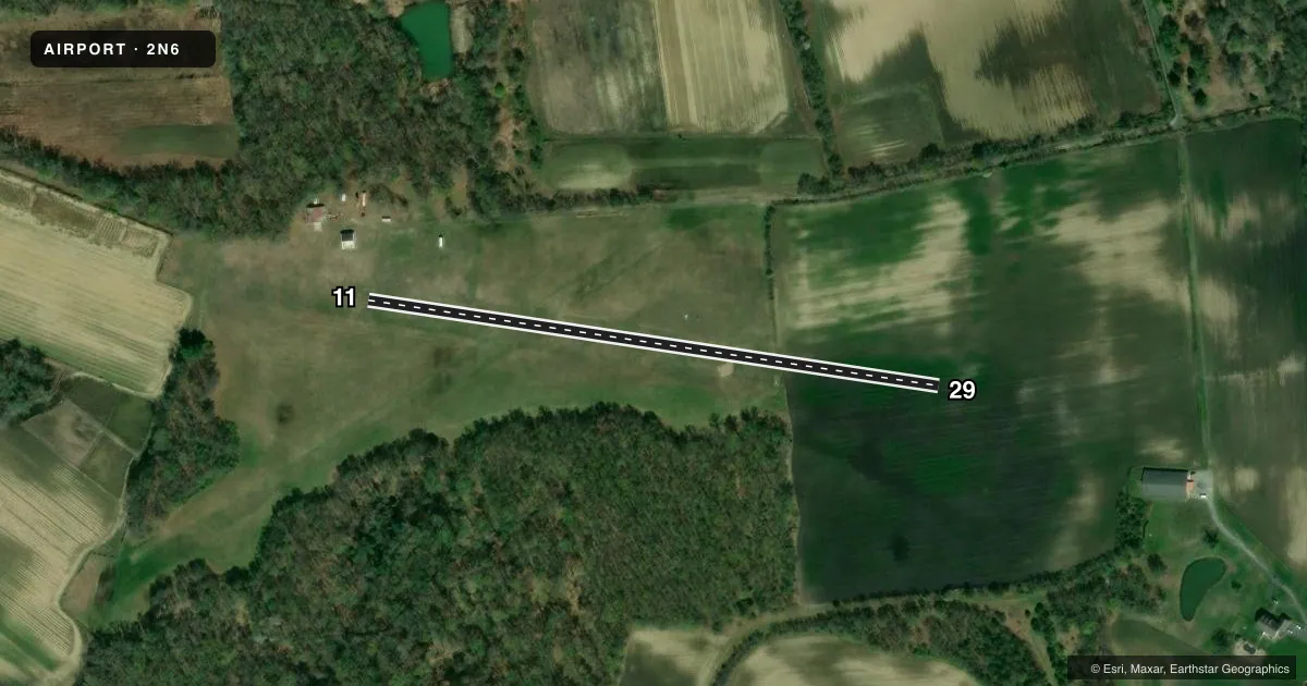
Airport sketch
Runways drawn to scale from FAA survey coordinates, rendered over satellite imagery. Not for navigation.
Approaches & charts
Services on the field
Fuel grades, oxygen, maintenance, ramp storage and lighting — as declared to the FAA by the airport operator.
Fuel & services
- Fuel
- Not available
- Oxygen (bottled)
- Not available
- Oxygen (bulk)
- Not available
- Airframe repair
- Not available
- Power plant repair
- Not available
Ramp & ground
- Transient storage
- Tie-down
- Landing fee
- No fee published
- Customs
- Not available
- Wind indicator
- Yes
- Segmented circle
- No
Fuel & FBOs
Cheapest 100LL and Jet A on the field and nearby. Always confirm with the FBO before taxi.
Airport notes
Surface conditions, obstructions, local procedures, lighting outages and other notes published with each FAA cycle.
General notes
- NSTD LTG RWY 11/29 OTS INDEFLY.
- FOR CD CTC MC GUIRE APCH AT 609-754-2767.
- DEER & BIRDS ON & INVOF ARPT.
- TSNT ACFT CALL AMGR OR 609-915-8281 FOR ACES.
Runway surface & condition
- 11/29LGTS INOP.
Approach & departure obstructions
- 06RY 06 FIRST HALF, TREES WITHIN 90 FT OF CTLN.
- 24RWY 24 ADDTNL OBSTRS, +35 TO +62 FT TREES, DIST 320-400 FT, 80-120 FT L.
Other notes
- STD LEFT TFC PATTERN AT REDWING AIRPORT IS COMPATIBLE W/TFC PTN OPERATION AT PEMBERTON ARPT & MCGUIRE AFB...VFR WX CONDS.
VFR map & nearby airports
VFR sectional. Tap any ICAO chip to open that airport.
Key facts · 2N6
Answer card- ICAO
- 2N6
- Name
- REDWING
- Location
- JOBSTOWN, NEW JERSEY
- Elevation
- 78 ft MSL
- Traffic pattern altitude
- 1,078 ft MSL (1,000 AGL)
- Control tower
- Non-towered (use CTAF)
- Total runways
- 1
- Longest runway
- 11/29 · 1,590 ft
- Published ILS approaches
- 0
- Published frequencies
- 1
- Magnetic variation
- 12°
- Current flight rules
- VFR
- Current wind
- Calm / unavailable
- Favored runway now
- –
Redwing Airport (2N6) sits in Jobstown, New Jersey at 78 ft MSL. It has one runway. The longest is 11/29 at 1,590 ft on turf. There is no control tower. CTAF is 122.9. No ILS approaches are published.
The published pattern altitude is not listed. Use the standard 1,000 ft AGL pattern for light piston operations unless the current Chart Supplement says otherwise. The field sits in a busy South Jersey traffic environment. The published remarks say the standard left pattern is compatible with Pemberton Airport and McGuire Air Force Base when VFR conditions allow. That makes good radio discipline important.
Plan for wildlife on and near the field. Deer and birds are specifically noted. The remarks also say runway 11 and 29 lights are inoperative. Nonstandard lighting for 11 and 29 is out of service indefinitely. If you need clearance delivery, contact McGuire Approach at 609-754-2767. Transient aircraft should call the airport manager or 609-915-8281 for access. There are no on-field FBOs listed, so verify services with the airport operator before you go.