METAR & TAF KVAY
Current METAR
Observed 00:54Z
KVAY 270054Z AUTO A2984 RMK AO2 SLPNO PWINO $
- Wind
- Calm
- Visibility
- —
- Temp / Dew
- —
- Altimeter
- 29.84 inHg
- Clouds
- Clear
- Density alt
- —
- Ceiling
- Unlimited
- Rules
- VFR
Airport info & contacts
Manager on record, flight service, ARTCC, attendance schedule and pattern altitude — published by the FAA and refreshed every 28 days.
Location
- From city
- 4 NM SW
- VFR sectional
- WASHINGTON
- Pattern altitude
- 800 ft AGL · 853 ft MSL
- ARTCC
- ZNY · NEW YORK
- NOTAM facility
- VAY (NOTAM-D)
Airport manager
- Name
- MINDY KIMBALL
- Phone
- 609-267-3131
- Address
- 68 STACY HAINES RD., LUMBERTON NJ 08048
Flight service · Hours
- FSS MIV
- MILLVILLE1-800-WX-BRIEF
- Attendance
- APR-OCT · 0800-2000
- NOV-MAR · 0800-1800
Frequencies
Tap any row to copy the frequency to your clipboard.
Runways & pattern
Full pagePattern entry · RWY 08
LEFT TRAFFICRunway end performance
| End | TORA | TODA | ASDA | LDA | VGSI | Approach lights | Obstruction |
|---|---|---|---|---|---|---|---|
| 08 | — | — | — | — | PAPI 2-box right(3.25°) | — | 54', tree, 550' from thr, 170' R of cntrln, slope 6 |
| 26 | — | — | — | — | PAPI 2-box right(3°) | — | 45', tree, 909' from thr, 99' R of cntrln, slope 15 |
Declared distances in feet. TORA = takeoff run available, TODA = takeoff distance, ASDA = accelerate-stop, LDA = landing distance.
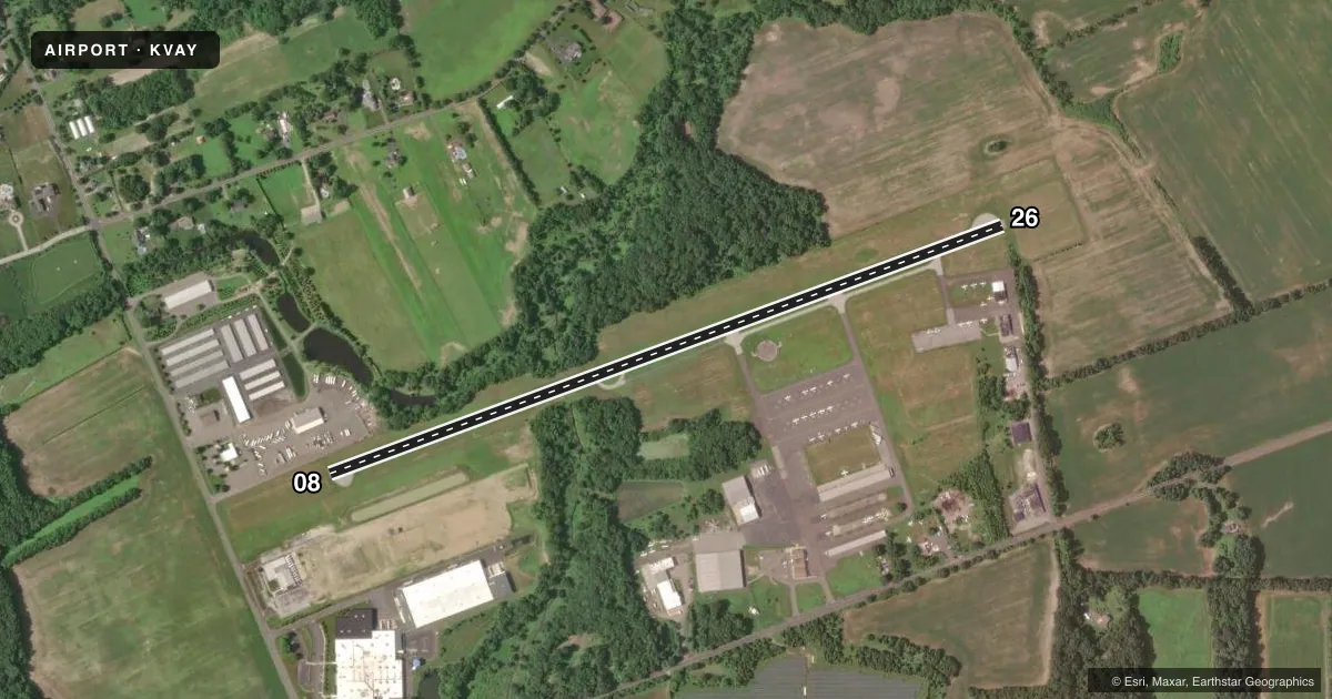
Airport sketch
Runways drawn to scale from FAA survey coordinates, rendered over satellite imagery. Not for navigation.
Approaches & charts
Services on the field
Fuel grades, oxygen, maintenance, ramp storage and lighting — as declared to the FAA by the airport operator.
Fuel & services
- Fuel
- 100LLA
- Oxygen (bottled)
- Not available
- Oxygen (bulk)
- Not available
- Airframe repair
- Major
- Power plant repair
- Major
- Other services
- AMB,INSTR
Ramp & ground
- Transient storage
- Tie-down
- Hangar
- Landing fee
- No fee published
- Customs
- Not available
- Lighting schedule
- SEE RMK
- Beacon schedule
- SS-SR
- Beacon
- White / Green (civil land)(WG)
- Wind indicator
- Lighted
- Segmented circle
- Yes
Fuel & FBOs
Cheapest 100LL and Jet A on the field and nearby. Always confirm with the FBO before taxi.
Airport notes
Surface conditions, obstructions, local procedures, lighting outages and other notes published with each FAA cycle.
General notes
- TREES ALONG SIDES OF RY PRIMARILY NW.
- BALLS MKG PLINES ON APH TO RY 08 FADED.
- DEER ON & INVOF ARPT.
- HELICOPTER TAKEOFFS AND LANDINGS RESTRICTED TO RY 08/26 ONLY.
- PARALLEL TAXIWAY NON-STANDARD WIDTH, 18 FT ASP.
- AVOID OVERFLYING HOUSING AREA WNW OF ARPT BELOW 300 FT WHEN IN THE TRAFFIC PATTERN FOR RWY 8.
- FOR CD CTC MC GUIRE APCH AT 609-754-2767.
Lighting notes
- ACTVT MIRL RY 08/26 AND REIL RY 08 & 26 -123.3.
Other notes
- 1ARPT UNATNDD THANKSGIVING & CHRISTMAS DAY. CHRISTMAS & THANKSGIVING EVE HRS 0800-1200. NEW YEARS DAY HRS 1100-1800.
VFR map & nearby airports
VFR sectional. Tap any ICAO chip to open that airport.
Key facts · KVAY
Answer card- ICAO
- KVAY
- Name
- SOUTH JERSEY RGNL
- Location
- MOUNT HOLLY, NEW JERSEY
- Elevation
- 52.8 ft MSL
- Traffic pattern altitude
- 852.8 ft MSL (800 AGL)
- Control tower
- Non-towered (use CTAF)
- Total runways
- 1
- Longest runway
- 08/26 · 3,881 ft
- Published ILS approaches
- 0
- Published frequencies
- 4
- Magnetic variation
- 12°
- Current flight rules
- VFR
- Current wind
- Calm / unavailable
- Favored runway now
- –
South Jersey Rgnl is in Mount Holly, New Jersey. The field elevation is 52.8 ft MSL. It has one runway, 08/26, which is 3,881 ft long. There is no control tower. Pattern altitude is 800 ft AGL, which is 852.8 ft MSL.
No ILS approaches are published here. CTAF and UNICOM are both 122.8. McGuire Approach handles the listed approach and departure frequencies. For clearance delivery, the published remark says to contact McGuire Approach at 609-754-2767. The on-field FBO is South Jersey Airport. It carries AVGAS 100LL and Jet A. Call (609) 267-3131 for current service details.
A few local items matter on a first visit. Ball markings and plines on the approach to runway 08 are faded. Deer are on and near the airport. Trees line the runway sides, mainly to the northwest. Avoid overflying the housing area west-northwest of the airport below 300 feet when flying the runway 08 pattern. Helicopter takeoffs and landings are restricted to runway 08/26 only. The runway lights are medium intensity and are activated by radio on 123.3. Runway end identifier lights are also published for both ends. Check the current Chart Supplement before departure for any updates to these remarks.