METAR & TAF 17N
17N does not publish a METAR.
Showing the nearest reporting station: KPHL (PHILADELPHIA INTL) · 13.9 NM away. Conditions at 17N may differ.
METAR · KPHL
Observed 11:54Z
KPHL 271154Z 25006KT 10SM FEW075 SCT110 SCT140 SCT260 23/19 A2985 RMK AO2 SLP109 T02280189 10233 20211 51011 $
- Wind
- 250° @ 6 kt
- Visibility
- 10 SM
- Temp / Dew
- 23°C / 19°C
- Altimeter
- 29.85 inHg
- Clouds
- SCT
- Density alt
- 1,248 ft
- Ceiling
- Unlimited
- Rules
- VFR
Airport info & contacts
Manager on record, flight service, ARTCC, attendance schedule and pattern altitude — published by the FAA and refreshed every 28 days.
Location
- From city
- 1 NM S
- VFR sectional
- WASHINGTON
- Pattern altitude
- 838 ft AGL · 1,000 ft MSL
- ARTCC
- ZNY · NEW YORK
- NOTAM facility
- MIV (NOTAM-D)
Airport manager
- Name
- HARRY STRAHLENDORF
- Phone
- 856-629-3033
- Address
- 1531 N. TUCKAHOE ROAD, WILLIAMSTOWN NJ 08094
Flight service · Hours
- FSS MIV
- MILLVILLE1-800-WX-BRIEF
- Attendance
- 0800-1700
Frequencies
Tap any row to copy the frequency to your clipboard.
Runways & pattern
Full pagePattern entry · RWY 27
LEFT TRAFFICRunway end performance
| End | TORA | TODA | ASDA | LDA | VGSI | Approach lights | Obstruction |
|---|---|---|---|---|---|---|---|
| 09 | — | — | — | — | — | — | 90', trees, 900' from thr, 250' R of cntrln, slope 7 |
| 27 | — | — | — | — | — | — | 73', tree, 570' from thr, 135' R of cntrln, slope 5 |
Declared distances in feet. TORA = takeoff run available, TODA = takeoff distance, ASDA = accelerate-stop, LDA = landing distance.
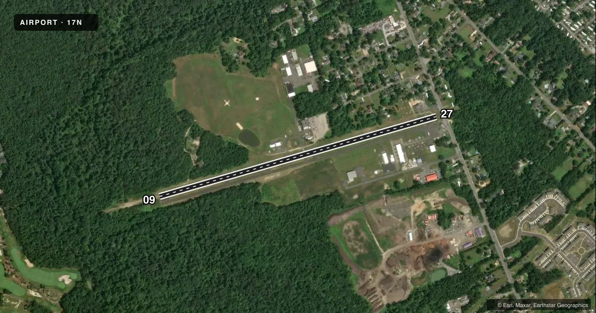
Airport sketch
Runways drawn to scale from FAA survey coordinates, rendered over satellite imagery. Not for navigation.
Approaches & charts
Services on the field
Fuel grades, oxygen, maintenance, ramp storage and lighting — as declared to the FAA by the airport operator.
Fuel & services
- Fuel
- 100LLA
- Oxygen (bottled)
- Not available
- Oxygen (bulk)
- Not available
- Airframe repair
- Minor
- Power plant repair
- Minor
- Other services
- INSTR,PAJA,RNTL
Ramp & ground
- Transient storage
- Tie-down
- Landing fee
- No fee published
- Customs
- Not available
- Lighting schedule
- SS-SR
- Beacon schedule
- SS-SR
- Beacon
- White / Green (civil land)(WG)
- Wind indicator
- Lighted
- Segmented circle
- No
Fuel & FBOs
Cheapest 100LL and Jet A on the field and nearby. Always confirm with the FBO before taxi.
Airport notes
Surface conditions, obstructions, local procedures, lighting outages and other notes published with each FAA cycle.
General notes
- DUE TO PARACHUTE DROP ZONE ON N SIDE OF ARPT, ALL TFC TO REMAIN S OF RWY 09/27.
- DEER & BIRDS ON & INVOF ARPT.
- ARPT UNATTND THANKSGIVING, CHRISTMAS, NEW YEAR'S DAY AND EASTER.
- FOR CD CTC PHILADELPHIA APCH AT 800-354-9884.
Runway surface & condition
- 09/27LIRL LGT SPACING NSTD.
Approach & departure obstructions
- 09+20 FT TREES 50 FT RT & LFT OF EXTD CTLN 0-200 FT FM APP END. +60 FT TREES 200 FT RT & LFT OF EXTD CTLN AT APP END.
- 27DSPLCD THLD MARKED WITH LGTS.
- 09TREES ARE 125' R & L OF CNTRL EXTNDD.
- 27ROAD, FENCE, BLDGS, & TREES NEAR APCH END.
Other notes
- THIS AIRPORT HAS BEEN SURVEYED BY THE NATIONAL GEODETIC SURVEY.
VFR map & nearby airports
VFR sectional. Tap any ICAO chip to open that airport.
Key facts · 17N
Answer card- ICAO
- 17N
- Name
- CROSS KEYS
- Location
- CROSS KEYS, NEW JERSEY
- Elevation
- 162 ft MSL
- Traffic pattern altitude
- 1,000 ft MSL (838 AGL)
- Control tower
- Non-towered (use CTAF)
- Total runways
- 1
- Longest runway
- 09/27 · 3,500 ft
- Published ILS approaches
- 0
- Published frequencies
- 5
- Magnetic variation
- 10°
- Current flight rules
- VFR
- Current wind
- 250° at 6 kt
- Favored runway now
- RWY 27
Cross Keys Airport sits in Cross Keys, New Jersey. Field elevation is 162 ft MSL. It has one runway. Runway 09/27 is 3,500 ft long with an asphalt surface. The airport is non-towered. Pattern altitude is 838 ft AGL, which is 1,000 ft MSL.
No ILS approaches are published here. The on-field FBO is Cross Keys Airport. It carries 100LL and Jet A Prist. Call the FBO at (856) 629-3033 for current availability before you go. The published remarks also matter here. Deer and birds are reported on and near the airport. Traffic must stay south of runway 09/27 because of a parachute drop zone on the north side. Runway 09 has trees close to the extended centerline. Runway 27 has road, fence, buildings and trees near the approach end. The displaced threshold on 27 is lit. Low intensity runway lights are installed with nonstandard spacing.
For a first-time arrival, plan for a short field with obstacle awareness on both ends. Keep the pattern south of the runway. If you need clearance delivery, contact Philadelphia Approach at 800-354-9884. Check the current FAA Chart Supplement before flight for any updated remarks or operational changes.