METAR & TAF 28N
28N does not publish a METAR.
Showing the nearest reporting station: KMIV (MILLVILLE MUNI) · 11.4 NM away. Conditions at 28N may differ.
METAR · KMIV
Observed 00:54Z
KMIV 270054Z AUTO 00000KT 10SM CLR 22/16 A2986 RMK AO2 SLP111 T02170156 $
- Wind
- 000° @ 0 kt
- Visibility
- 10 SM
- Temp / Dew
- 22°C / 16°C
- Altimeter
- 29.86 inHg
- Clouds
- CLR
- Density alt
- 1,063 ft
- Ceiling
- Unlimited
- Rules
- VFR
Airport info & contacts
Manager on record, flight service, ARTCC, attendance schedule and pattern altitude — published by the FAA and refreshed every 28 days.
Location
- From city
- 4 NM NE
- VFR sectional
- WASHINGTON
- Pattern altitude
- 1,200 ft AGL · 1,320 ft MSL
- ARTCC
- ZDC · WASHINGTON
- NOTAM facility
- MIV (NOTAM-D)
Airport manager
- Name
- CURTIS NIXHOLM
- Phone
- 856-207-6027
- Address
- 339 HARDING HWY, VINELAND NJ 08360
Flight service · Hours
- FSS MIV
- MILLVILLE1-800-WX-BRIEF
- Attendance
- APR-NOV · 0800-1600
- DEC-MAR · UNATTND · UNATTND
Frequencies
Tap any row to copy the frequency to your clipboard.
Runways & pattern
Full pagePattern entry · RWY 12
LEFT TRAFFICRunway end performance
| End | TORA | TODA | ASDA | LDA | VGSI | Approach lights | Obstruction |
|---|---|---|---|---|---|---|---|
| 12 | — | — | — | — | — | — | 4', fence, 18' from thr, 0' R of cntrln, slope 4 |
| 30 | — | — | — | — | — | — | 4', fence, 18' from thr, 0' R of cntrln, slope 4 |
Declared distances in feet. TORA = takeoff run available, TODA = takeoff distance, ASDA = accelerate-stop, LDA = landing distance.
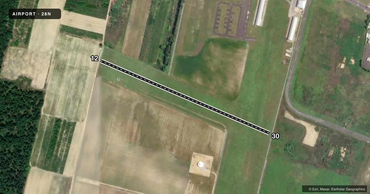
Airport sketch
Runways drawn to scale from FAA survey coordinates, rendered over satellite imagery. Not for navigation.
Approaches & charts
Services on the field
Fuel grades, oxygen, maintenance, ramp storage and lighting — as declared to the FAA by the airport operator.
Fuel & services
- Fuel
- 100LLA
- Oxygen (bottled)
- Not available
- Oxygen (bulk)
- Not available
- Airframe repair
- Major
- Power plant repair
- Major
- Other services
- AGRI
Ramp & ground
- Transient storage
- Tie-down
- Landing fee
- No fee published
- Customs
- Not available
- Lighting schedule
- SEE RMK
- Wind indicator
- Yes
- Segmented circle
- No
Fuel & FBOs
Cheapest 100LL and Jet A on the field and nearby. Always confirm with the FBO before taxi.
Airport notes
Surface conditions, obstructions, local procedures, lighting outages and other notes published with each FAA cycle.
General notes
- ARPT CLSD AT NIGHT TO TRANSIENTS.
- HEAVY AGRICULTURAL OPNS APR-OCT.
- RADIO CTL MODELS OPR ON RY 12.
- RY 12/30 RESTRICTED TO AGRICULTURAL AND FIREFIGHTING ACFT ONLY.
- FOR CD CTC WASHINGTON ARTCC AT 703-771-3587.
Lighting notes
- ARPT LGTS PPR CALL 856-697-3300.
Fuel notes
- 100LLFOR FUEL PHONE 856-697-3300.
Runway surface & condition
- 02/20RWY 02/20 NONSTANDARD LIRL DUE TO SPACING. THLD & RWY END LGTS NONSTANDARD COLORS.
Approach & departure obstructions
- 20ADDITIONAL OBSTR: TREES TO 80-130 FT BEFORE LDG THLD, 200 FT RT OF CTLN & 40 FT MKD/LGTD PLINE 500 FT BEFORE LDG THLD.
Other notes
- ARPT IN OPERN SINCE 1945.
VFR map & nearby airports
VFR sectional. Tap any ICAO chip to open that airport.
Key facts · 28N
Answer card- ICAO
- 28N
- Name
- VINELAND-DOWNSTOWN
- Location
- VINELAND, NEW JERSEY
- Elevation
- 120 ft MSL
- Traffic pattern altitude
- 1,320 ft MSL (1,200 AGL)
- Control tower
- Non-towered (use CTAF)
- Total runways
- 1
- Longest runway
- 12/30 · 1,800 ft
- Published ILS approaches
- 0
- Published frequencies
- 2
- Magnetic variation
- 11°
- Current flight rules
- VFR
- Current wind
- 000° at 0 kt
- Favored runway now
- –
Vineland-Downstown (28N) sits in Vineland, New Jersey. Field elevation is 120 ft MSL. The airport has one runway. Runway 12/30 is 1,800 ft of turf. The published pattern altitude is 1,200 ft AGL, which is 1,320 ft MSL. There is no control tower. CTAF and UNICOM are both 122.8. No ILS approaches are published.
This field is set up for agricultural and firefighting use. Runway 12/30 is restricted to those aircraft only. Published remarks also note radio controlled models on runway 12. Trees 80 to 130 ft tall sit before the landing threshold. A marked and lighted power line is also noted 500 ft before the threshold, 200 ft right of centerline. That makes a careful arrival brief important.
Downstown Aero Crop Service is on the field. It carries AVGAS 100LL and JET A. Call (856) 697-3300 for fuel or airport lights. Airport lights are prior permission required. The airport is closed at night to transient aircraft. Heavy agricultural operations run from April through October. If you need clearance delivery, contact Washington ARTCC at 703-771-3587. Check the current FAA Chart Supplement before flying in if you need the latest operating notes.