METAR & TAF 00N
00N does not publish a METAR.
Showing the nearest reporting station: KMIV (MILLVILLE MUNI) · 8.2 NM away. Conditions at 00N may differ.
METAR · KMIV
Observed 23:54Z
KMIV 262354Z AUTO 00000KT 10SM CLR 23/16 A2985 RMK AO2 SLP107 T02280161 10278 20228 58000 $
- Wind
- 000° @ 0 kt
- Visibility
- 10 SM
- Temp / Dew
- 23°C / 16°C
- Altimeter
- 29.85 inHg
- Clouds
- CLR
- Density alt
- 1,181 ft
- Ceiling
- Unlimited
- Rules
- VFR
Airport info & contacts
Manager on record, flight service, ARTCC, attendance schedule and pattern altitude — published by the FAA and refreshed every 28 days.
Location
- From city
- 3 NM NE
- VFR sectional
- WASHINGTON
- ARTCC
- ZDC · WASHINGTON
- NOTAM facility
- MIV (NOTAM-D)
Airport manager
- Name
- AARON PEARL
- Phone
- 609-805-0408
- Address
- 19 PARVIN MILL RD, BRIDGETON NJ 08302
Flight service · Hours
- FSS MIV
- MILLVILLE1-800-WX-BRIEF
- Attendance
- Unattended
Frequencies
Tap any row to copy the frequency to your clipboard.
Runways & pattern
Full pagePattern entry · RWY 18
LEFT TRAFFICRunway end performance
| End | TORA | TODA | ASDA | LDA | VGSI | Approach lights | Obstruction |
|---|---|---|---|---|---|---|---|
| 18 | — | — | — | — | — | — | 27', tree, 15' from thr, 120' R of cntrln, slope 0 |
| 36 | — | — | — | — | — | — | 38', tree, 135' from thr, 90' R of cntrln, slope 3 |
Declared distances in feet. TORA = takeoff run available, TODA = takeoff distance, ASDA = accelerate-stop, LDA = landing distance.
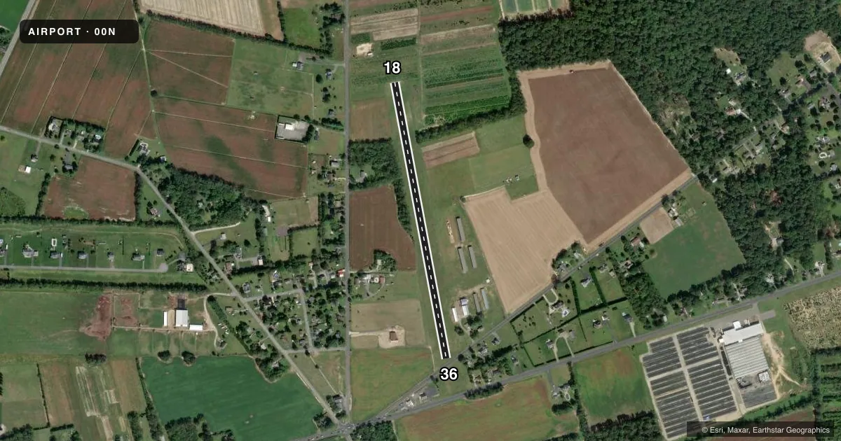
Airport sketch
Runways drawn to scale from FAA survey coordinates, rendered over satellite imagery. Not for navigation.
Approaches & charts
Services on the field
Fuel grades, oxygen, maintenance, ramp storage and lighting — as declared to the FAA by the airport operator.
Fuel & services
- Fuel
- 100LL
- Oxygen (bottled)
- Not available
- Oxygen (bulk)
- Not available
- Airframe repair
- Minor
- Power plant repair
- Minor
- Other services
- INSTR,RNTL
Ramp & ground
- Transient storage
- Tie-down
- Hangar
- Landing fee
- No fee published
- Customs
- Not available
- Lighting schedule
- SEE RMK
- Wind indicator
- Yes
- Segmented circle
- No
Fuel & FBOs
Cheapest 100LL and Jet A on the field and nearby. Always confirm with the FBO before taxi.
Airport notes
Surface conditions, obstructions, local procedures, lighting outages and other notes published with each FAA cycle.
General notes
- FOR CD CTC WASHINGTON ARTCC AT 703-771-3587.
- DEER & BIRDS ON & INVOF ARPT.
Lighting notes
- ACTVT LIRL RWY 18/36 - CTAF.
Runway surface & condition
- 18/36NSTD LTG CONFIG.
Approach & departure obstructions
- 36RY 36 ADD'L CTLG OBST+55 FT-65 FT TREES 500 FT FM THLD 40-75 FT RIGHT. +46 FT MKD PLINE 330 FT FM THLD.
Other notes
- ARPT EXISTED PRIOR TO MAY 15 1959.
VFR map & nearby airports
VFR sectional. Tap any ICAO chip to open that airport.
Key facts · 00N
Answer card- ICAO
- 00N
- Name
- BUCKS
- Location
- BRIDGETON, NEW JERSEY
- Elevation
- 108 ft MSL
- Traffic pattern altitude
- 1,108 ft MSL (1,000 AGL)
- Control tower
- Non-towered (use CTAF)
- Total runways
- 1
- Longest runway
- 18/36 · 2,420 ft
- Published ILS approaches
- 0
- Published frequencies
- 1
- Magnetic variation
- 11°
- Current flight rules
- VFR
- Current wind
- 000° at 0 kt
- Favored runway now
- –
BUCKS is in Bridgeton, New Jersey. The field elevation is 108 ft MSL. It has one runway. Runway 18/36 is 2,420 ft of turf, so plan for soft-field performance and keep the length in mind if the runway is wet or soft. There is no control tower. CTAF is 122.9.
No ILS approaches are published here. The pattern altitude is not published, so use the standard 1,000 ft AGL unless the current FAA Chart Supplement says otherwise. The runway lighting is nonstandard. Low intensity lights on 18/36 are activated by CTAF.
There are no on-field FBOs listed for 00N. Contact the airport operator directly before arrival, or call the field on CTAF for current FBO availability. Published remarks also call out deer and birds in the area, so keep a sharp lookout on arrival and departure. Runway 36 has cataloged obstacles near the threshold, including trees and a marked power line. That makes a stabilized approach important. The airport is close to the Delaware Valley traffic flow, so check the current FAA Chart Supplement for any noise or operating notes before you go.