METAR & TAF 0N4
0N4 does not publish a METAR.
Showing the nearest reporting station: KDOV (DOVER AFB) · 4.5 NM away. Conditions at 0N4 may differ.
METAR · KDOV
Observed 12:55Z
KDOV 271255Z AUTO 21004KT 10SM CLR 23/19 A2983 RMK AO2 SLP105 T02300189
- Wind
- 210° @ 4 kt
- Visibility
- 10 SM
- Temp / Dew
- 23°C / 19°C
- Altimeter
- 29.83 inHg
- Clouds
- CLR
- Density alt
- 1,099 ft
- Ceiling
- Unlimited
- Rules
- VFR
Airport info & contacts
Manager on record, flight service, ARTCC, attendance schedule and pattern altitude — published by the FAA and refreshed every 28 days.
Location
- From city
- 3 NM NE
- VFR sectional
- WASHINGTON
- ARTCC
- ZDC · WASHINGTON
- NOTAM facility
- MIV (NOTAM-D)
Airport manager
- Name
- JUSTIN D. HOFFMAN
- Phone
- 302-287-9623
- Address
- 114 KRUSER BLVD, DOVER DE 19901
Flight service · Hours
- FSS MIV
- MILLVILLE1-800-WX-BRIEF
- Attendance
- MON-FRI · 0800-1600
- SAT-SUN · ON CALL
Frequencies
Tap any row to copy the frequency to your clipboard.
Runways & pattern
Full pagePattern entry · RWY 22
LEFT TRAFFICRunway end performance
| End | TORA | TODA | ASDA | LDA | VGSI | Approach lights | Obstruction |
|---|---|---|---|---|---|---|---|
| 04 | — | — | — | — | — | — | 42', trees, 264' from thr, 81' R of cntrln, slope 1 |
| 22 | — | — | — | — | — | — | 79', trees, 507' from thr, 0' R of cntrln, slope 4 |
Declared distances in feet. TORA = takeoff run available, TODA = takeoff distance, ASDA = accelerate-stop, LDA = landing distance.
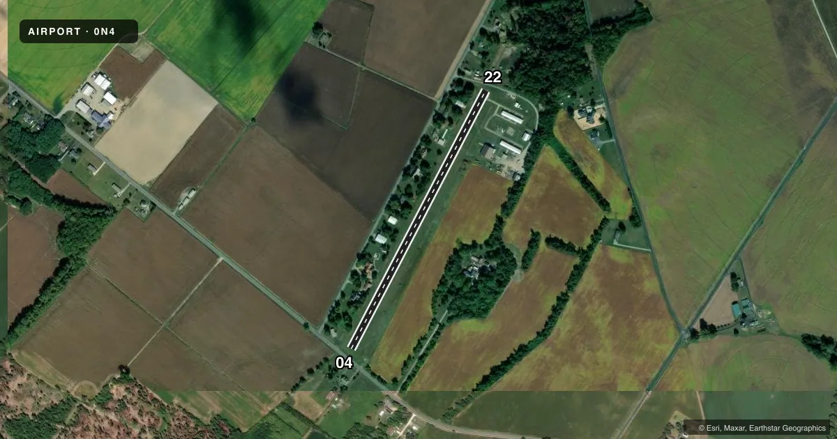
Airport sketch
Runways drawn to scale from FAA survey coordinates, rendered over satellite imagery. Not for navigation.
Approaches & charts
Services on the field
Fuel grades, oxygen, maintenance, ramp storage and lighting — as declared to the FAA by the airport operator.
Fuel & services
- Fuel
- 100LLMOGAS
- Oxygen (bottled)
- Not available
- Oxygen (bulk)
- Not available
- Airframe repair
- Major
- Power plant repair
- Major
- Other services
- AGRI,AMB,INSTR,SALES,SURV
Ramp & ground
- Transient storage
- Tie-down
- Hangar
- Landing fee
- No fee published
- Customs
- Not available
- Lighting schedule
- SEE RMK
- Beacon schedule
- SEE RMK
- Beacon
- White / Green (civil land)(WG)
- Wind indicator
- Lighted
- Segmented circle
- No
Fuel & FBOs
Cheapest 100LL and Jet A on the field and nearby. Always confirm with the FBO before taxi.
Airport notes
Surface conditions, obstructions, local procedures, lighting outages and other notes published with each FAA cycle.
General notes
- HEAVY BIRD ACTIVITY ON & INVOF ARPT OCT-FEB.
- FOR CD CTC WASHINGTON ARTCC AT 703-771-3587.
- TREE TRIMMING ON RWY END 04 CMPLTD. TREE REMOVAL ON RWY END 22 ON-GOING.
Lighting notes
- ACTVT ROTG BCN - 122.7.
- ACTVT LIRL RWY 04/22 - 122.7.
Approach & departure obstructions
- 04TREES, ROAD & POWER LINES ACROSS THE WIDTH OF PRIMARY SFC.
- 22TREES & BLDG ACROSS WIDTH OF PRIMARY SFC.
- 04DSPLCD THLD MKD WITH WHITE LINE; DASHED WHITE LINES LEADING TO DSPLCD THLD IS FADED.
- 22DSPLCD THLD MKD WITH WHITE LINE; DASHED WHITE LINES LEADING TO DSPLCD THLD IS FADED.
- 04APCH SLOPE 19:1 TO DSPLCD THLD.
- 22APCH RATIO 13:1 TO DTHR.
Other notes
- VFR USE ONLY
- SUBJECT TO AVAILABILITY CALL (302) 287-9623
- AVAILABLE UPON REQUEST CALL (302) 287-9623
- 1FOR SERVICES AFTER HOURS CALL (302) 287-9623
- 2FOR SERVICES CALL (302) 287-9623
- 04/22HAS VERTICAL, HORIZONTAL AND ALLIGATOR CRACKING.
VFR map & nearby airports
VFR sectional. Tap any ICAO chip to open that airport.
Key facts · 0N4
Answer card- ICAO
- 0N4
- Name
- CHANDELLE
- Location
- DOVER, DELAWARE
- Elevation
- 22 ft MSL
- Traffic pattern altitude
- 1,022 ft MSL (1,000 AGL)
- Control tower
- Non-towered (use CTAF)
- Total runways
- 1
- Longest runway
- 04/22 · 2,533 ft
- Published ILS approaches
- 0
- Published frequencies
- 2
- Magnetic variation
- 11°
- Current flight rules
- VFR
- Current wind
- 210° at 4 kt
- Favored runway now
- RWY 22
Chandelle is in Dover, Delaware. The field elevation is 22 ft MSL. It has one runway, 04/22, which is 2,533 ft long. There is no control tower. Pattern altitude is not published, so verify the current pattern altitude before arrival. No ILS approaches are published here.
The airport uses CTAF and UNICOM 122.8. The published remarks matter here. Heavy bird activity is reported from October through February. Runway 04 has trees, a road and power lines crossing the width of the primary surface near the runway end. Runway 22 has an ongoing tree removal issue near the end. The displaced thresholds on both runway ends are marked, but the dashed markings are faded. Low intensity runway lights and the rotating beacon are activated on 122.7.
No on-field FBOs are listed, so plan on confirming services directly with the airport operator or by phone before you go. For after-hours service, transient storage, or tie-downs, the published number is the one to call. Clearance delivery is handled through Washington ARTCC. For a first-time arrival, treat this as a small non-towered field with local lighting procedures and some runway-end obstacles to review carefully before you depart.