METAR & TAF 15N
15N does not publish a METAR.
Showing the nearest reporting station: KDOV (DOVER AFB) · 5.6 NM away. Conditions at 15N may differ.
METAR · KDOV
Observed 12:55Z
KDOV 271255Z AUTO 21004KT 10SM CLR 23/19 A2983 RMK AO2 SLP105 T02300189
- Wind
- 210° @ 4 kt
- Visibility
- 10 SM
- Temp / Dew
- 23°C / 19°C
- Altimeter
- 29.83 inHg
- Clouds
- CLR
- Density alt
- 1,137 ft
- Ceiling
- Unlimited
- Rules
- VFR
Airport info & contacts
Manager on record, flight service, ARTCC, attendance schedule and pattern altitude — published by the FAA and refreshed every 28 days.
Location
- From city
- 1 NM W
- VFR sectional
- WASHINGTON
- ARTCC
- ZDC · WASHINGTON
- NOTAM facility
- MIV (NOTAM-D)
Airport manager
- Name
- JOE C. JENKINS
- Phone
- 302-697-7743
- Address
- 9935 WESTVILLE RD, WYOMING DE 19934
Flight service · Hours
- FSS MIV
- MILLVILLE1-800-WX-BRIEF
- Attendance
- ALL
Frequencies
Tap any row to copy the frequency to your clipboard.
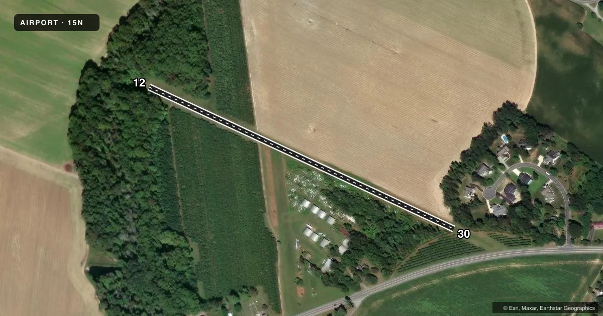
Runways & pattern
Full pagePattern entry · RWY 30
LEFT TRAFFICRunway end performance
| End | TORA | TODA | ASDA | LDA | VGSI | Approach lights | Obstruction |
|---|---|---|---|---|---|---|---|
| 12 | — | — | — | — | — | — | 97', trees, 255' from thr, 80' R of cntrln, slope 2 |
| 30 | — | — | — | — | — | — | 64', trees, 100' from thr, 50' R of cntrln, slope 1 |
Declared distances in feet. TORA = takeoff run available, TODA = takeoff distance, ASDA = accelerate-stop, LDA = landing distance.
Airport sketch
Runways drawn to scale from FAA survey coordinates, rendered over satellite imagery. Not for navigation.
Approaches & charts
Services on the field
Fuel grades, oxygen, maintenance, ramp storage and lighting — as declared to the FAA by the airport operator.
Fuel & services
- Fuel
- Not available
- Oxygen (bottled)
- Not available
- Oxygen (bulk)
- Not available
- Airframe repair
- Major
- Power plant repair
- Major
- Other services
- SALES
Ramp & ground
- Transient storage
- Hangar
- Landing fee
- No fee published
- Customs
- Not available
- Beacon schedule
- SEE RMK
- Beacon
- White / Green (civil land)(WG)
- Wind indicator
- Yes
- Segmented circle
- No
Fuel & FBOs
Cheapest 100LL and Jet A on the field and nearby. Always confirm with the FBO before taxi.
Airport notes
Surface conditions, obstructions, local procedures, lighting outages and other notes published with each FAA cycle.
General notes
- FOR CD CTC WASHINGTON ARTCC AT 703-771-3587.
- ORCHARDS EITHER SIDE OF RWY MAY ATTRACT BIRDS.
Lighting notes
- ACTVT ROTG BCN - 122.8.
Other notes
- EXISTED PRIOR TO 1959.
- SALESACFT PARTS.
VFR map & nearby airports
VFR sectional. Tap any ICAO chip to open that airport.
Key facts · 15N
Answer card- ICAO
- 15N
- Name
- JENKINS
- Location
- WYOMING, DELAWARE
- Elevation
- 53 ft MSL
- Traffic pattern altitude
- 1,053 ft MSL (1,000 AGL)
- Control tower
- Non-towered (use CTAF)
- Total runways
- 1
- Longest runway
- 12/30 · 2,035 ft
- Published ILS approaches
- 0
- Published frequencies
- 2
- Magnetic variation
- 11°
- Current flight rules
- VFR
- Current wind
- 210° at 4 kt
- Favored runway now
- RWY 30
JENKINS (15N) sits in Wyoming, Delaware. The field elevation is 53 ft MSL. It has one runway, 12/30, which is 2,035 ft of turf. The airport is unattended. CTAF and UNICOM are both 122.8. No ILS approaches are published here.
Pattern altitude is not published. Use the standard 1,000 ft AGL pattern unless the current Chart Supplement says otherwise. That puts the traffic pattern at 1,053 ft MSL based on the listed field elevation. Orchards on either side of the runway can draw birds. Plan for that on departure and arrival. The rotating beacon is activated on 122.8. Aircraft parts are available on the field. Clearance delivery for IFR pickup goes through Washington ARTCC at 703-771-3587.
For a first visit, treat this as a short turf strip with limited margin. Check runway condition before you go. Watch your weight, density altitude and landing distance. If you need current operational details, verify them with the airport operator or the current FAA Chart Supplement before launch.