METAR & TAF KMIV
Current METAR
Observed 11:54Z
KMIV 271154Z AUTO 00000KT 10SM CLR 20/18 A2986 RMK AO2 SLP109 60009 70009 T02000183 10206 20189 53004 $
- Wind
- 000° @ 0 kt
- Visibility
- 10 SM
- Temp / Dew
- 20°C / 18°C
- Altimeter
- 29.86 inHg
- Clouds
- CLR
- Density alt
- 779 ft
- Ceiling
- Unlimited
- Rules
- VFR
Airport info & contacts
Manager on record, flight service, ARTCC, attendance schedule and pattern altitude — published by the FAA and refreshed every 28 days.
Location
- From city
- 3 NM SW
- VFR sectional
- WASHINGTON
- ARTCC
- ZDC · WASHINGTON
- NOTAM facility
- MIV (NOTAM-D)
Airport manager
- Name
- JOE MULHERON
- Phone
- 302-757-2952
- Address
- ADMIN BLDG, 104 LEDDON ST, MILLVILLE NJ 08332
Flight service · Hours
- FSS MIV
- MILLVILLE1-800-WX-BRIEF
- Attendance
- 0800-1600
Frequencies
Tap any row to copy the frequency to your clipboard.
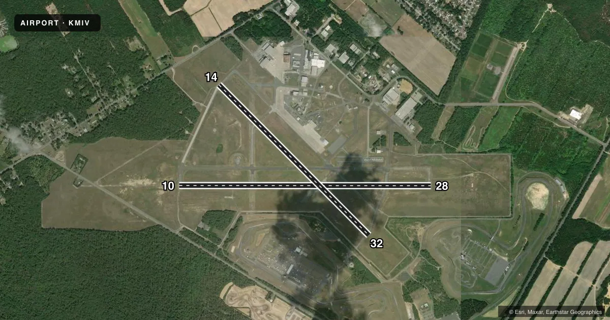
Runways & pattern
Full pagePattern entry · RWY 10
LEFT TRAFFIC| Runway | Heading (°M) | Length | Surface | Traffic |
|---|---|---|---|---|
| 10/28 | 79° / 259° | 6,003 ft | ASPH | Standard L |
| 14/32 | 124° / 304° | 5,058 ft | CONC | Standard L |
Runway end performance
| End | TORA | TODA | ASDA | LDA | VGSI | Approach lights | Obstruction |
|---|---|---|---|---|---|---|---|
| 10 | — | — | — | — | PAPI 4-box left(3°) | MALSR | 65', trees, 2480' from thr, 170' R of cntrln, slope 35 |
| 28 | — | — | — | — | PAPI 4-box left(3°) | — | — |
| 14 | — | — | — | — | PAPI 4-box left(3°) | — | 49', trees, 2160' from thr, 190' R of cntrln, slope 40 |
| 32 | — | — | — | — | PAPI 4-box left(3°) | — | 55', trees, 1335' from thr, 0' R of cntrln, slope 20 |
Declared distances in feet. TORA = takeoff run available, TODA = takeoff distance, ASDA = accelerate-stop, LDA = landing distance.
Airport sketch
Runways drawn to scale from FAA survey coordinates, rendered over satellite imagery. Not for navigation.
Approaches & charts
ILS · 1
Services on the field
Fuel grades, oxygen, maintenance, ramp storage and lighting — as declared to the FAA by the airport operator.
Fuel & services
- Fuel
- 100LLA
- Oxygen (bottled)
- Not available
- Oxygen (bulk)
- Not available
- Airframe repair
- Not available
- Power plant repair
- Minor
- Other services
- INSTR,RNTL
Ramp & ground
- Transient storage
- Tie-down
- Landing fee
- No fee published
- Customs
- Not available
- Lighting schedule
- SEE RMK
- Beacon schedule
- SS-SR
- Beacon
- White / Green (civil land)(WG)
- Wind indicator
- Lighted
- Segmented circle
- No
Fuel & FBOs
Cheapest 100LL and Jet A on the field and nearby. Always confirm with the FBO before taxi.
Airport notes
Surface conditions, obstructions, local procedures, lighting outages and other notes published with each FAA cycle.
General notes
- ALL ULTRALIGHT ACFT, GLDR OPS & FRMN FLTS PPR. CALL 856-825-1244 MON-FRI 0800-1600.
- PAEW WI ALL RWY & TWY SAFETY AREAS DLY MAY-OCT.
- TWY G NOT TO BE USED BY ACFT WITH WINGSPAN GTR THAN 48 FT N OF TWY A.
- MAIN APN CLSD TO TSNT ACFT N OF TWY K.
- BIRDS ON & INVOF ARPT.
- FOR CD IF UNA TO CTC ON FSS FREQ, CTC ATLANTIC CITY APPROACH AT 609-485-6193.
- FENCE LINE 44 FT N OF TWY G CNTRLN, N OF TWY A.
- ARPT SFC CONDS NOT RPRTD 0800-1600.
Lighting notes
- ACTVT MALSR RWY 10; MIRL 10/28 & 14/32 - CTAF.
Fuel notes
- 100LLSELF SERV AVBL 24 HRS WITH CREDIT CARD.
Approach & departure obstructions
- 10CALM WIND RWY.
VFR map & nearby airports
VFR sectional. Tap any ICAO chip to open that airport.
Key facts · KMIV
Answer card- ICAO
- KMIV
- Name
- MILLVILLE MUNI
- Location
- MILLVILLE, NEW JERSEY
- Elevation
- 84.6 ft MSL
- Traffic pattern altitude
- 1,084.6 ft MSL (1,000 AGL)
- Control tower
- Non-towered (use CTAF)
- Total runways
- 2
- Longest runway
- 10/28 · 6,003 ft
- Published ILS approaches
- 1
- Published frequencies
- 4
- Magnetic variation
- 11°
- Current flight rules
- VFR
- Current wind
- 000° at 0 kt
- Favored runway now
- –
Millville Muni sits in Millville, New Jersey. Field elevation is 84.6 ft MSL. The airport has two runways. The longest is runway 10/28 at 6,003 ft. Runway 14/32 is 5,058 ft. There is no control tower, so expect non-towered operations on CTAF 123.0 or UNICOM 123.0. The published pattern altitude is not listed, so use the standard 1,000 ft AGL for light piston traffic unless current local guidance says otherwise.
Runway 10 has the only published ILS approach. The field uses Atlantic City Approach for approach and departure services on 124.6 and 327.125. Big Sky Aviation is on the field. It carries 100LL and Jet A Prist. Self-serve 100LL is available 24 hours with a credit card. That is useful for late arrivals. Runway 10 is the calm wind runway. The Chart Supplement also notes birds in and around the airport, so keep a sharp scan on climbout and final.
First-time pilots should pay attention to the published field remarks before arrival. The main apron is closed to transient aircraft north of taxiway K. Taxiway G has a wingspan limit north of taxiway A. Airport surface conditions are not reported from 0800 to 1600. If you need clearance delivery and cannot reach Flight Service, Atlantic City Approach is the backup contact.