METAR & TAF KOBI
KOBI does not publish a METAR.
Showing the nearest reporting station: KWWD (CAPE MAY COUNTY) · 13.7 NM away. Conditions at KOBI may differ.
METAR · KWWD
Observed 12:56Z
KWWD 271256Z AUTO 16005KT 10SM CLR 23/21 A2987 RMK AO2 SLP115 T02330206 $
- Wind
- 160° @ 5 kt
- Visibility
- 10 SM
- Temp / Dew
- 23°C / 21°C
- Altimeter
- 29.87 inHg
- Clouds
- CLR
- Density alt
- 1,073 ft
- Ceiling
- Unlimited
- Rules
- VFR
Airport info & contacts
Manager on record, flight service, ARTCC, attendance schedule and pattern altitude — published by the FAA and refreshed every 28 days.
Location
- From city
- 2 NM SE
- VFR sectional
- WASHINGTON
- ARTCC
- ZDC · WASHINGTON
- NOTAM facility
- MIV (NOTAM-D)
Airport manager
- Name
- LAURIE E. BOYD
- Phone
- 609-861-5301
- Address
- 501 WASHINGTON AVENUE, WOODBINE NJ 08270
Flight service · Hours
- FSS MIV
- MILLVILLE1-800-WX-BRIEF
- Attendance
- MON-FRI · 0830-1430
Frequencies
Tap any row to copy the frequency to your clipboard.
Runways & pattern
Full pagePattern entry · RWY 19
LEFT TRAFFIC| Runway | Heading (°M) | Length | Surface | Traffic |
|---|---|---|---|---|
| 01/19Favored | 348° / 168° | 3,304 ft | ASPH | Standard L |
| 13/31 | 108° / 288° | 3,074 ft | ASPH | Standard L |
Runway end performance
| End | TORA | TODA | ASDA | LDA | VGSI | Approach lights | Obstruction |
|---|---|---|---|---|---|---|---|
| 01 | — | — | — | — | — | — | 31', trees, 316' from thr, 158' R of cntrln, slope 3 |
| 19 | — | — | — | — | PAPI 2-box left(3.7°) | — | 43', trees, 768' from thr, 322' R of cntrln, slope 12 |
| 13 | — | — | — | — | PAPI 2-box left(3°) | — | 60', trees, 1808' from thr, 206' R of cntrln, slope 26 |
| 31 | — | — | — | — | PAPI 2-box right(3.5°) | — | 24', trees, 481' from thr, 151' R of cntrln, slope 11 |
Declared distances in feet. TORA = takeoff run available, TODA = takeoff distance, ASDA = accelerate-stop, LDA = landing distance.
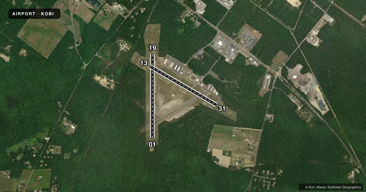
Airport sketch
Runways drawn to scale from FAA survey coordinates, rendered over satellite imagery. Not for navigation.
Approaches & charts
Services on the field
Fuel grades, oxygen, maintenance, ramp storage and lighting — as declared to the FAA by the airport operator.
Fuel & services
- Fuel
- 100LL
- Oxygen (bottled)
- Not available
- Oxygen (bulk)
- Not available
- Airframe repair
- Major
- Power plant repair
- Major
- Other services
- AMB,INSTR,RNTL
Ramp & ground
- Transient storage
- Tie-down
- Landing fee
- No fee published
- Customs
- Not available
- Lighting schedule
- SEE RMK
- Beacon schedule
- SS-SR
- Beacon
- White / Green (civil land)(WG)
- Wind indicator
- Lighted
- Segmented circle
- No
Fuel & FBOs
Cheapest 100LL and Jet A on the field and nearby. Always confirm with the FBO before taxi.
Airport notes
Surface conditions, obstructions, local procedures, lighting outages and other notes published with each FAA cycle.
General notes
- BANNER TOWING OPS MEMORIAL THRU LABOR DAY OCNL OTHER TIMES.
- GCO AVBL ON FREQ 121.725 THRU ATLANTIC CITY APCH CONTROL.
- MEDEVAC HEL ACTVTY ALL DAYS & HRS.
- FOR CD IF UNA VIA GCO CTC WASHINGTON ARTCC AT 703-771-3587.
Lighting notes
- ACTVT MIRL RWY 13/31 & 01/19 - CTAF.
Approach & departure obstructions
- 13PAPI HIGH INTST ONLY.
- 19PAPI HIGH INTST ONLY.
- 31PAPI HIGH INTST ONLY.
Other notes
- 01/19SGFNT NR OF LONGL AND TRANSVERSE CRACKS ON RWY WITH WEEDS AND GRASS GROWING IN CRACKS.
- 13/31SGFNT NR OF LONGL AND TRANSVERSE CRACKS ON RWY WITH GRASS AND WEEDS GROWING IN CRACKS.
VFR map & nearby airports
VFR sectional. Tap any ICAO chip to open that airport.
Key facts · KOBI
Answer card- ICAO
- KOBI
- Name
- WOODBINE MUNI
- Location
- WOODBINE, NEW JERSEY
- Elevation
- 41 ft MSL
- Traffic pattern altitude
- 1,041 ft MSL (1,000 AGL)
- Control tower
- Non-towered (use CTAF)
- Total runways
- 2
- Longest runway
- 01/19 · 3,304 ft
- Published ILS approaches
- 0
- Published frequencies
- 4
- Magnetic variation
- 12°
- Current flight rules
- VFR
- Current wind
- 160° at 5 kt
- Favored runway now
- RWY 19
Woodbine Muni is in Woodbine, New Jersey. The field elevation is 41 ft MSL. It has two asphalt runways. The longest is runway 01/19 at 3,304 ft. Runway 13/31 is 3,074 ft.
There is no control tower. Traffic uses CTAF 123.05. Approach and departure service is handled by Atlantic City on 124.6 and 327.125. No ILS approaches are published here. The pattern altitude is not published, so use the standard 1,000 ft AGL for light piston operations unless the current Chart Supplement says otherwise.
Woodbine Municipal Airport is the on-field FBO. It carries 100LL. Call (609) 861-1300 before arrival if you need current ramp or fuel details. The published remarks matter here. Both runways have medium intensity lights activated on CTAF. The PAPI on runways 13, 19 and 31 is high intensity only. Runway surfaces also have reported cracking with weeds and grass in the cracks on both runways. That is worth checking before you plan a heavier arrival.
This is a non-towered field with medical helicopter activity all day and night. Banner towing also happens here from Memorial Day through Labor Day, with occasional operations at other times. Expect a busy local traffic picture. Check the current Chart Supplement for any published noise or operating restrictions before you fly in.