METAR & TAF KWWD
Current METAR
Observed 12:56Z
KWWD 271256Z AUTO 16005KT 10SM CLR 23/21 A2987 RMK AO2 SLP115 T02330206 $
- Wind
- 160° @ 5 kt
- Visibility
- 10 SM
- Temp / Dew
- 23°C / 21°C
- Altimeter
- 29.87 inHg
- Clouds
- CLR
- Density alt
- 1,049 ft
- Ceiling
- Unlimited
- Rules
- VFR
Airport info & contacts
Manager on record, flight service, ARTCC, attendance schedule and pattern altitude — published by the FAA and refreshed every 28 days.
Location
- From city
- 4 NM NW
- VFR sectional
- WASHINGTON
- ARTCC
- ZDC · WASHINGTON
- NOTAM facility
- WWD (NOTAM-D)
Airport manager
- Name
- JOE MULHERON
- Phone
- 302-757-2952
- Address
- 201 FORRESTAL RD, RIO GRANDE NJ 08242
Flight service · Hours
- FSS MIV
- MILLVILLE1-800-WX-BRIEF
- Attendance
- 0800-1700
Frequencies
Tap any row to copy the frequency to your clipboard.
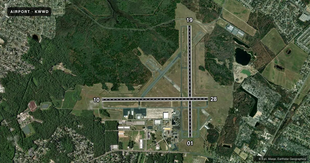
Runways & pattern
Full pagePattern entry · RWY 19
LEFT TRAFFIC| Runway | Heading (°M) | Length | Surface | Traffic |
|---|---|---|---|---|
| 01/19Favored | 350° / 170° | 5,252 ft | ASPH | Standard L |
| 10/28 | 80° / 260° | 5,000 ft | ASPH | Standard L |
Runway end performance
| End | TORA | TODA | ASDA | LDA | VGSI | Approach lights | Obstruction |
|---|---|---|---|---|---|---|---|
| 01 | 5,252' | 5,252' | 5,036' | 5,036' | PAPI 4-box left(3°) | — | 55', tree, 1140' from thr, 130' R of cntrln, slope 17 |
| 19 | 5,252' | 5,252' | 5,252' | 5,036' | PAPI 4-box left(3°) | — | 13', road, 260' from thr, 0' R of cntrln, slope 4 |
| 10 | — | — | — | — | PAPI 4-box left(3°) | — | 80', trees, 2000' from thr, 0' R of cntrln, slope 22 |
| 28 | — | — | — | — | PAPI 4-box left(3°) | — | 297', tower, 9290' from thr, 660' R of cntrln, slope 30 |
Declared distances in feet. TORA = takeoff run available, TODA = takeoff distance, ASDA = accelerate-stop, LDA = landing distance.
Airport sketch
Runways drawn to scale from FAA survey coordinates, rendered over satellite imagery. Not for navigation.
Approaches & charts
ILS · 1
Services on the field
Fuel grades, oxygen, maintenance, ramp storage and lighting — as declared to the FAA by the airport operator.
Fuel & services
- Fuel
- 100LLA
- Oxygen (bottled)
- Not available
- Oxygen (bulk)
- Not available
- Airframe repair
- Minor
- Power plant repair
- Minor
- Other services
- INSTR
Ramp & ground
- Transient storage
- Tie-down
- Hangar
- Landing fee
- No fee published
- Customs
- Not available
- Lighting schedule
- SEE RMK
- Beacon schedule
- SS-SR
- Beacon
- White / Green (civil land)(WG)
- Wind indicator
- Lighted
- Segmented circle
- No
Fuel & FBOs
Cheapest 100LL and Jet A on the field and nearby. Always confirm with the FBO before taxi.
Airport notes
Surface conditions, obstructions, local procedures, lighting outages and other notes published with each FAA cycle.
General notes
- BIRDS ON & INVOF ARPT.
- TWY B SOUTH OF TWY A CAN ONLY BE USED BY ACFT WITH WINGSPANS LESS THAN 79 FT.
- PAEW WITHIN THE SAFETY AREAS OF ALL RYS AND TWYS DAILY MAY THRU OCT.
- TWY A WEST OF TWY F CAN ONLY BE USED BY ACFT WITH WINGSPANS LESS THAN 79 FT.
- UNMANNED AIRCRAFT SYSTEMS (UAS) ACTIVITY ON AND AROUND AIRFIELD.
- ALL ULTRALIGHT ACFT, GLIDER OPS AND FORMATION FLTS PPR. CALL (609) 886-8652 MON-FRI 0800-1600.
- FOR CD CTC ATLANTIC CITY APCH AT 609-485-6192.
- TWY C IS AN FAA RESEARCH TWY AND IS RSTRD TO ACFT WITH WT LMT OF 28,000 LB AND SHOULD NOT BE USED BY ACFT GTR THAN 28,000 LB.
- ARPT SFC CONDS NOT RPRTD 0800-1600.
Lighting notes
- ACTVT PAPI RWY 01, 10, 19, & 28; HIRL RWY 01/19; MIRL RWY 10/28 - CTAF.
Fuel notes
- 100LLSELF SERV AVBL H24 WITH CREDIT CARD LCTD ON APRON NEAR INTXN OF TWY A & F.
Approach & departure obstructions
- 19CALM WIND RWY.
- 19APCH RATIO 22:1 TO DSPLCD THR.
Other notes
- EXISTED BEFORE FAR 157 RQRMT.
- OWNERDRBA IS LESSEE. PROPERTY OWNED BY CAPE MAY COUNTY, PO BOX 365, CAPE MAY COURT HOUSE, N.J. 08210. 609-886-0901.
VFR map & nearby airports
VFR sectional. Tap any ICAO chip to open that airport.
Key facts · KWWD
Answer card- ICAO
- KWWD
- Name
- CAPE MAY COUNTY
- Location
- WILDWOOD, NEW JERSEY
- Elevation
- 21.7 ft MSL
- Traffic pattern altitude
- 1,021.7 ft MSL (1,000 AGL)
- Control tower
- Non-towered (use CTAF)
- Total runways
- 2
- Longest runway
- 01/19 · 5,252 ft
- Published ILS approaches
- 1
- Published frequencies
- 5
- Magnetic variation
- 10°
- Current flight rules
- VFR
- Current wind
- 160° at 5 kt
- Favored runway now
- RWY 19
Cape May County Airport sits in Wildwood, New Jersey. Field elevation is 21.7 ft MSL. The airport has two asphalt runways. The longest is 5,252 ft on runway 01/19. There is no control tower. Clearance delivery goes through Atlantic City Approach. The published pattern altitude is not listed, so use the standard 1,000 ft AGL for light piston traffic unless the current FAA Chart Supplement says otherwise.
The field has one ILS approach to runway 19. Runway 19 is also listed as the calm wind runway. FlightLevel Aviation is on the field. It carries 100LL, Jet A and Jet A Prist. Self-serve 100LL is available 24 hours with a credit card on the apron near the intersection of taxiways A and F. PAPI is active on runways 01, 10, 19 and 28. High intensity lighting is on 01/19. Medium intensity lighting is on 10/28.
A first-time pilot should pay attention to the bird activity reported on and near the airport. Taxiway C is restricted to aircraft under 28,000 lb. The airport also reports that surface conditions are not published from 0800 to 1600. Ultralight, glider and formation operations need prior permission. Check the current FAA Chart Supplement for any noise or curfew restrictions before flying in.