METAR & TAF 29N
29N does not publish a METAR.
Showing the nearest reporting station: KMIV (MILLVILLE MUNI) · 9.5 NM away. Conditions at 29N may differ.
METAR · KMIV
Observed 11:54Z
KMIV 271154Z AUTO 00000KT 10SM CLR 20/18 A2986 RMK AO2 SLP109 60009 70009 T02000183 10206 20189 53004 $
- Wind
- 000° @ 0 kt
- Visibility
- 10 SM
- Temp / Dew
- 20°C / 18°C
- Altimeter
- 29.86 inHg
- Clouds
- CLR
- Density alt
- 790 ft
- Ceiling
- Unlimited
- Rules
- VFR
Airport info & contacts
Manager on record, flight service, ARTCC, attendance schedule and pattern altitude — published by the FAA and refreshed every 28 days.
Location
- From city
- 3 NM N
- VFR sectional
- WASHINGTON
- ARTCC
- ZDC · WASHINGTON
- NOTAM facility
- MIV (NOTAM-D)
Airport manager
- Name
- ROBERT PANTALEO
- Phone
- 856-794-2134
- Address
- 1242 W. GARDEN ROAD, VINELAND NJ 08360
Flight service · Hours
- FSS MIV
- MILLVILLE1-800-WX-BRIEF
- Attendance
- Unattended
Frequencies
Tap any row to copy the frequency to your clipboard.
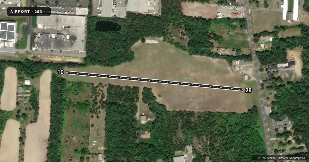
Runways & pattern
Full pagePattern entry · RWY 10
LEFT TRAFFICRunway end performance
| End | TORA | TODA | ASDA | LDA | VGSI | Approach lights | Obstruction |
|---|---|---|---|---|---|---|---|
| 10 | — | — | — | — | — | — | 47', tree, 20' from thr, 90' R of cntrln, slope 0 |
| 28 | — | — | — | — | — | — | 32', pline, 90' from thr, 0' R of cntrln, slope 2 |
Declared distances in feet. TORA = takeoff run available, TODA = takeoff distance, ASDA = accelerate-stop, LDA = landing distance.
Airport sketch
Runways drawn to scale from FAA survey coordinates, rendered over satellite imagery. Not for navigation.
Approaches & charts
Services on the field
Fuel grades, oxygen, maintenance, ramp storage and lighting — as declared to the FAA by the airport operator.
Fuel & services
- Fuel
- Not available
Ramp & ground
- Transient storage
- Not published
- Landing fee
- No fee published
- Wind indicator
- Yes
- Segmented circle
- No
Fuel & FBOs
Cheapest 100LL and Jet A on the field and nearby. Always confirm with the FBO before taxi.
Airport notes
Surface conditions, obstructions, local procedures, lighting outages and other notes published with each FAA cycle.
General notes
- RY 10 TREES NEAR APCH END & ALONG RY SIDES.
- TALL TREES ON SHORT FINAL RY 28.
- FOR CD CTC WASHINGTON ARTCC AT 703-771-3587.
- DEER & BIRDS ON & INVOF ARPT.
Other notes
- EXISTED PRIOR TO 5/15/59.
VFR map & nearby airports
VFR sectional. Tap any ICAO chip to open that airport.
Key facts · 29N
Answer card- ICAO
- 29N
- Name
- KROELINGER
- Location
- VINELAND, NEW JERSEY
- Elevation
- 93 ft MSL
- Traffic pattern altitude
- 1,093 ft MSL (1,000 AGL)
- Control tower
- Non-towered (use CTAF)
- Total runways
- 1
- Longest runway
- 10/28 · 2,086 ft
- Published ILS approaches
- 0
- Published frequencies
- 3
- Magnetic variation
- 10°
- Current flight rules
- VFR
- Current wind
- 000° at 0 kt
- Favored runway now
- –
Kroelinger Airport (29N) sits in Vineland, New Jersey. The field elevation is 93 ft MSL. It has one runway. Runway 10/28 is a 2,086 ft turf strip with magnetic headings of 96° and 276°. The airport is non-towered. CTAF is 122.9. Atlantic City approach and departure are on 124.6 and 327.125.
No ILS approaches are published here. Pattern altitude is not published, so plan on the standard 1,000 ft AGL for light piston traffic unless the current Chart Supplement says otherwise. The field has no on-field FBOs listed, so call the airport operator directly or use the FBO directly by phone before you go.
Published remarks matter here. Trees sit near the approach end and along the sides of runway 10. Tall trees are on short final for runway 28. Deer and birds are also reported on and near the airport, so keep a sharp scan on arrival and departure. Clearance delivery is handled through Washington ARTCC at 703-771-3587. For a first visit, treat this as a short turf runway with obstacle awareness on both ends and a need to verify current field conditions before you launch.