METAR & TAF 19N
19N does not publish a METAR.
Showing the nearest reporting station: KVAY (SOUTH JERSEY RGNL) · 10.9 NM away. Conditions at 19N may differ.
METAR · KVAY
Observed 11:54Z
KVAY 271154Z AUTO A2985 RMK AO2 SLPNO 53010 PWINO $
- Wind
- Calm
- Visibility
- —
- Temp / Dew
- —
- Altimeter
- 29.85 inHg
- Clouds
- Clear
- Density alt
- —
- Ceiling
- Unlimited
- Rules
- VFR
Airport info & contacts
Manager on record, flight service, ARTCC, attendance schedule and pattern altitude — published by the FAA and refreshed every 28 days.
Location
- From city
- 1 NM SW
- VFR sectional
- WASHINGTON
- ARTCC
- ZNY · NEW YORK
- NOTAM facility
- MIV (NOTAM-D)
Airport manager
- Name
- KARL KLEINBERG
- Phone
- 856-767-1233
- Address
- 817 WATSONTOWN RD, BERLIN NJ 08009
Flight service · Hours
- FSS MIV
- MILLVILLE1-800-WX-BRIEF
- Attendance
- 0900-1500
Frequencies
Tap any row to copy the frequency to your clipboard.
Runways & pattern
Full pagePattern entry · RWY 05
LEFT TRAFFICRunway end performance
| End | TORA | TODA | ASDA | LDA | VGSI | Approach lights | Obstruction |
|---|---|---|---|---|---|---|---|
| 05 | — | — | — | — | PSIR(4°) | — | 38', trees, 211' from thr, 68' R of cntrln, slope 0 |
| 23 | — | — | — | — | PSIR(4°) | — | 78', trees, 253' from thr, 196' R of cntrln, slope 0 |
Declared distances in feet. TORA = takeoff run available, TODA = takeoff distance, ASDA = accelerate-stop, LDA = landing distance.
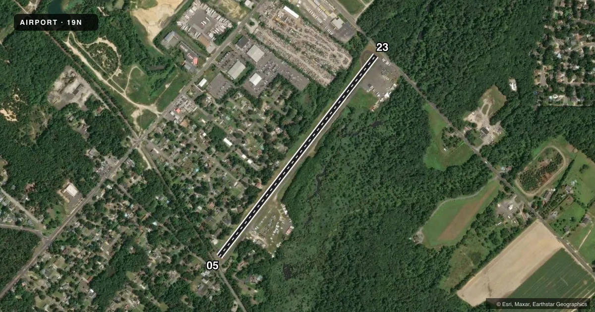
Airport sketch
Runways drawn to scale from FAA survey coordinates, rendered over satellite imagery. Not for navigation.
Approaches & charts
Services on the field
Fuel grades, oxygen, maintenance, ramp storage and lighting — as declared to the FAA by the airport operator.
Fuel & services
- Fuel
- A
- Oxygen (bottled)
- Not available
- Oxygen (bulk)
- Not available
- Airframe repair
- Major
- Power plant repair
- Major
- Other services
- SALES
Ramp & ground
- Transient storage
- Tie-down
- Landing fee
- No fee published
- Lighting schedule
- SEE RMK
- Beacon schedule
- SEE RMK
- Beacon
- White / Green (civil land)(WG)
- Wind indicator
- Lighted
- Segmented circle
- No
Fuel & FBOs
Cheapest 100LL and Jet A on the field and nearby. Always confirm with the FBO before taxi.
Airport notes
Surface conditions, obstructions, local procedures, lighting outages and other notes published with each FAA cycle.
General notes
- TREES ALONG NW SIDE OF RWY 05/23.
- TWY LINES & RWY HOLD LNS VERY FADED.
- NON-STANDARD RWY AND TWY LGT SPACING.
- FOR CD CTC MC GUIRE APCH AT 609-754-2767.
- DEER AND GEESE ON AND INVOF ARPT.
Lighting notes
- ACTVT ROTG BCN - CTAF.
- ACTVT REIL RWY 05/23; MIRL RWY 05/23 - CTAF.
Approach & departure obstructions
- 05+28 FT POLE 7 FT FROM RWY END 74 FT L.
- 23+44 FT TREE 37 FT FROM RWY END 206 FT R.
- 05OTS INDEF.
- 23OTS INDEF.
- 05+74 FT TREE, DIST 16 FT, 82 FT L, 0:1 BASED ON DSPLCD THLD.
- 23+47 FT TREE, DIST 6 FT, 140 FT R, 0:1 BASED ON DSPLCD THLD.
Other notes
- 1UNATTND CHRISTMAS AND NEW YEARS DAY.
- 05/23LRG LONGL CRACK IN MID OF RWY.
VFR map & nearby airports
VFR sectional. Tap any ICAO chip to open that airport.
Key facts · 19N
Answer card- ICAO
- 19N
- Name
- PINE VALLEY
- Location
- BERLIN, NEW JERSEY
- Elevation
- 150 ft MSL
- Traffic pattern altitude
- 1,150 ft MSL (1,000 AGL)
- Control tower
- Non-towered (use CTAF)
- Total runways
- 1
- Longest runway
- 05/23 · 3,094 ft
- Published ILS approaches
- 0
- Published frequencies
- 4
- Magnetic variation
- 12°
- Current flight rules
- VFR
- Current wind
- Calm / unavailable
- Favored runway now
- –
Pine Valley Airport sits in Berlin, New Jersey. Field elevation is 150 ft MSL. It has one runway. Runway 05/23 is 3,094 ft long and asphalt. There is no control tower. The pattern altitude is not published. Use 1,000 ft AGL for light piston traffic unless the current Chart Supplement says otherwise.
No ILS approaches are published here. Clearance delivery is handled through McGuire Approach. CTAF and UNICOM are both 123.0. The rotating beacon is activated on the CTAF. Runway 05/23 has runway end identifier lights and medium intensity runway lights that are also activated on the CTAF. The airport is unattended on Christmas and New Year's Day.
Pine Valley Airport has one on-field FBO. Pine Valley Airport carries Jet A. Call (856) 767-1233 for current service details. First-time pilots should pay close attention on final and on the ground. Trees line the northwest side of runway 05/23. There is a large longitudinal crack in the middle of the runway. Trees also sit close to both runway ends. Runway and taxiway lighting spacing is non-standard. Taxiway lines and runway hold lines are very faded. Deer and geese are present on and near the field.