METAR & TAF KACY
Current METAR
Observed 12:54Z
KACY 271254Z 24004KT 10SM BKN046 24/18 A2986 RMK AO2 SLP111 T02390178
- Wind
- 240° @ 4 kt
- Visibility
- 10 SM
- Temp / Dew
- 24°C / 18°C
- Altimeter
- 29.86 inHg
- Clouds
- BKN
- Density alt
- 1,247 ft
- Ceiling
- 4,600 ft AGL
- Rules
- VFR
Airport info & contacts
Manager on record, flight service, ARTCC, attendance schedule and pattern altitude — published by the FAA and refreshed every 28 days.
Location
- From city
- 9 NM NW
- VFR sectional
- WASHINGTON
- ARTCC
- ZDC · WASHINGTON
- NOTAM facility
- ACY (NOTAM-D)
Airport manager
- Name
- TIM KROLL
- Phone
- 609-645-7895
- Address
- SUITE 100, EGG HARBOR TOWNSHIP NJ 08234
Flight service · Hours
- FSS MIV
- MILLVILLE1-800-WX-BRIEF
- Attendance
- ALL
Frequencies
Tap any row to copy the frequency to your clipboard.
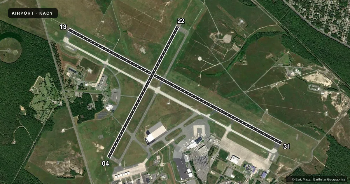
Runways & pattern
Full pagePattern entry · RWY 22
LEFT TRAFFIC| Runway | Heading (°M) | Length | Surface | Traffic |
|---|---|---|---|---|
| 13/31 | 108° / 288° | 10,001 ft | ASPH | Standard L |
| 04/22Favored | 18° / 198° | 6,145 ft | ASPH-CONC | Standard L |
Runway end performance
| End | TORA | TODA | ASDA | LDA | VGSI | Approach lights | Obstruction |
|---|---|---|---|---|---|---|---|
| 13 | 10,001' | 10,001' | 10,001' | 10,001' | PAPI 4-box left(3°) | MALSR | 64', tree, 2472' from thr, 708' R of cntrln, slope 36 |
| 31 | 10,001' | 10,001' | 10,001' | 10,001' | PAPI 4-box left(3°) | — | 50', tree, 1296' from thr, 622' R of cntrln, slope 22 |
| 04 | 6,145' | 6,145' | 6,145' | 6,145' | PAPI 4-box left(3°) | — | 64', tree, 2259' from thr, 471' R of cntrln, slope 32 |
| 22 | 6,145' | 6,145' | 6,145' | 6,145' | VASI 4-box left(3°) | — | 70', tree, 2073' from thr, 505' R of cntrln, slope 27 |
Declared distances in feet. TORA = takeoff run available, TODA = takeoff distance, ASDA = accelerate-stop, LDA = landing distance.
Airport sketch
Runways drawn to scale from FAA survey coordinates, rendered over satellite imagery. Not for navigation.
Approaches & charts
ILS · 2
Services on the field
Fuel grades, oxygen, maintenance, ramp storage and lighting — as declared to the FAA by the airport operator.
Fuel & services
- Fuel
- 100LLAA++
- Oxygen (bottled)
- High pressure
- Oxygen (bulk)
- Not available
- Airframe repair
- Major
- Power plant repair
- Minor
- Other services
- CHTR
Ramp & ground
- Transient storage
- Tie-down
- Landing fee
- Yes
- Customs
- Not available
- Beacon schedule
- SS-SR
- Beacon
- White / Green (civil land)(WG)
- Wind indicator
- Lighted
- Segmented circle
- No
Fuel & FBOs
Cheapest 100LL and Jet A on the field and nearby. Always confirm with the FBO before taxi.
Airport notes
Surface conditions, obstructions, local procedures, lighting outages and other notes published with each FAA cycle.
General notes
- FAA APRON PPR CALL 609-485-6482.
- TWY C CLSD TO DUAL TANDEM & DOUBLE TANDEM EQUIPPED ACFT.
- NO TRNG FLTS 2300-0700 LCL.
- FOX & BIRDS ON & INVOF ARPT.
- HIGH PER MIL ACFT OPERATING AT ARPT.
- NOISE ABATEMENT PROCS IN EFCT CTC ARPT OPNS AT (609) 645-7895 EXT 4702.
- MILITARY: ANG APRON PPR, CTC ANG BASE OPS C609-761-6009, FAX C609-761-6484, COMD POST C609-761-6001. LTD TRAN SVC AVBL 1100-2030Z++ TUE-FRI, CLSD SAT-MON AND HOL.
- MILITARY: ANG: BASH PHASE II IN EFCT APR-OCT CTC BASE OPS ON 261.0 OR 140.7 FOR CURRENT BASH COND.
- MILITARY: ANG: NSTD MRK ON ANG RAMPS: BLUE LINES DELINEATE F-16 WING TIP CLNC, YELLOW LINES AT HGR DOORS FOR PERS CLEAR ZONE.
- AVOID CNTRLN LGT DUR CABLE ENGAGEMENT TO PREVENT TAILHOOK BOUNCE.
- DURG ATC ZERO EVENTS, CTAF 120.3.
- ANG ARM/DEARM PADS FOR MIL USE ONLY.
- FOR ITINERANT MIL ACFT OPS PPR CTC ARPT OPS 609-645-7895 EXT 4702.
- PILOTS CONDUCTING EFVS OPS; BE AWARE LED ALS IN USE RWY 13.
- DE-ICING PAD FOR DE-ICING OPS ONLY. EXE CTC ARPT OPS 609-645-7895 EXT 4702.
Runway surface & condition
- 04/22PCR VALUE: 480/R/B/W/T
- 13/31PCR VALUE: 601/F/A/X/T
- H1PVT - EXPERIMENTAL USE ONLY. CTC FAA TECH CENTER AT 609-485-6675.
Arresting gear
- 13_BAK-14BAK-14 BAK-12B (B) (1600')
- 31_BAK-14BAK-14 BAK-12B (B) (1600')
Other notes
- EXISTED PRIOR TO 1959.
- US CUSTOMS USER FEE ARPT.CUSTOMS AVBL MON-FRI 0800-1700. PROVIDE MINIMUM 24 HR ADVANCE NOTICE TO ARRANGE FOR CUSTOMS. ALL CALLS TO CUSTOMS MON-FRI 0800-1700; PHONE 609-484-1610. US CUSTOMS FAX 609-484-1614.
- CHTRFOR CHARTER OPNS CTC 609-645-7895 EXT 4702.
VFR map & nearby airports
VFR sectional. Tap any ICAO chip to open that airport.
Key facts · KACY
Answer card- ICAO
- KACY
- Name
- ATLANTIC CITY INTL
- Location
- ATLANTIC CITY, NEW JERSEY
- Elevation
- 74.8 ft MSL
- Traffic pattern altitude
- 1,074.8 ft MSL (1,000 AGL)
- Control tower
- Towered · 24
- Total runways
- 2
- Longest runway
- 13/31 · 10,001 ft
- Published ILS approaches
- 2
- Published frequencies
- 20
- Magnetic variation
- 10°
- Current flight rules
- VFR
- Current wind
- 240° at 4 kt
- Favored runway now
- RWY 22
Atlantic City Intl sits in Atlantic City, New Jersey. Field elevation is 74.8 ft MSL. The airport has 2 runways. The longest is 13/31 at 10,001 ft. The tower is open 24 hours. Two ILS approaches are published, both on runway ends 13 and 31. Pattern altitude is not published in the facts, so use the current FAA Chart Supplement before you fly.
Signature Aviation is on the field. It carries 100LL and Jet A. Call ahead if you need current ramp or service details. This airport is in Class C airspace. The published remarks also flag military activity. Air National Guard operations use special apron procedures. Transient service can be limited. Bash Phase II is in effect from April through October. There is also a U.S. Customs user fee setup here. If you need customs, give at least 24 hours notice and confirm hours with the current FAA Chart Supplement or customs directly. No training flights are permitted between 2300 and 0700 local time. Runway 31 also has arresting gear. Review the current airport notes before arrival if you are operating anything unusual.