METAR & TAF 31E
31E does not publish a METAR.
Showing the nearest reporting station: KMJX (OCEAN COUNTY) · 15.7 NM away. Conditions at 31E may differ.
METAR · KMJX
Observed 00:56Z
KMJX 270056Z AUTO 13003KT 10SM CLR 22/16 A2986 RMK AO2 SLP115 T02170156 $
- Wind
- 130° @ 3 kt
- Visibility
- 10 SM
- Temp / Dew
- 22°C / 16°C
- Altimeter
- 29.86 inHg
- Clouds
- CLR
- Density alt
- 962 ft
- Ceiling
- Unlimited
- Rules
- VFR
Airport info & contacts
Manager on record, flight service, ARTCC, attendance schedule and pattern altitude — published by the FAA and refreshed every 28 days.
Location
- From city
- 2 NM N
- VFR sectional
- WASHINGTON
- ARTCC
- ZDC · WASHINGTON
- NOTAM facility
- MIV (NOTAM-D)
Airport manager
- Name
- SAL MAZZA
- Phone
- 609-296-1229
- Address
- 100 AIRPORT ROAD, PO BOX 129, WEST CREEK NJ 08092
Flight service · Hours
- FSS MIV
- MILLVILLE1-800-WX-BRIEF
- Attendance
- NOV-MAR · 7 · SR-SS
- APR-OCT · 7 · 0900-1700
Frequencies
Tap any row to copy the frequency to your clipboard.
Runways & pattern
Full pagePattern entry · RWY 14
LEFT TRAFFICRunway end performance
| End | TORA | TODA | ASDA | LDA | VGSI | Approach lights | Obstruction |
|---|---|---|---|---|---|---|---|
| 14 | — | — | — | — | PAPI 2-box left(4°) | — | 58', tree, 785' from thr, 126' R of cntrln, slope 10 |
| 32 | — | — | — | — | PAPI 2-box left(4°) | — | 64', tree, 484' from thr, 92' R of cntrln, slope 4 |
Declared distances in feet. TORA = takeoff run available, TODA = takeoff distance, ASDA = accelerate-stop, LDA = landing distance.
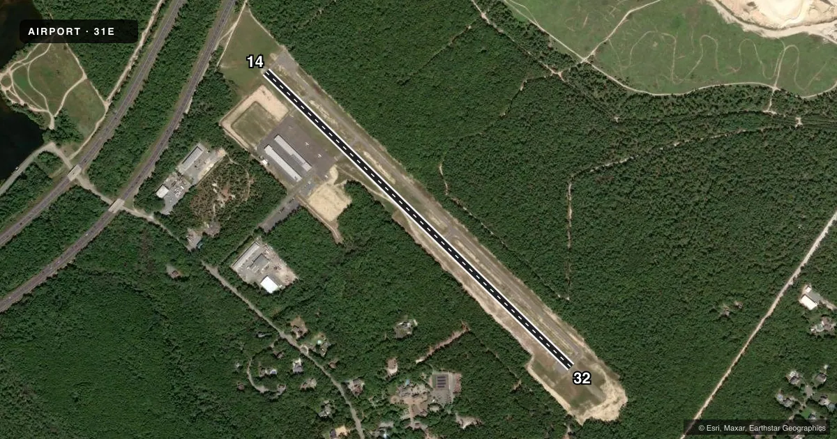
Airport sketch
Runways drawn to scale from FAA survey coordinates, rendered over satellite imagery. Not for navigation.
Approaches & charts
Services on the field
Fuel grades, oxygen, maintenance, ramp storage and lighting — as declared to the FAA by the airport operator.
Fuel & services
- Fuel
- 100LL
- Oxygen (bottled)
- Not available
- Oxygen (bulk)
- Not available
- Airframe repair
- Major
- Power plant repair
- Major
- Other services
- INSTR,PAJA
Ramp & ground
- Transient storage
- Tie-down
- Landing fee
- No fee published
- Lighting schedule
- SEE RMK
- Beacon schedule
- SS-SR
- Beacon
- White / Green (civil land)(WG)
- Wind indicator
- Yes
- Segmented circle
- No
Fuel & FBOs
Cheapest 100LL and Jet A on the field and nearby. Always confirm with the FBO before taxi.
Airport notes
Surface conditions, obstructions, local procedures, lighting outages and other notes published with each FAA cycle.
General notes
- REMOTE CTL ACFT OPER ADJ TO RY.
- PARACHUTE DROP ZONE SW CORNER OF ARPT
- DEER ON & INVOF ARPT.
- FOR CD CTC WASHINGTON ARTCC AT 703-771-3587.
- BTN THE HRS OF SS-SR TAKE OFF RWY 32 ONLY, LDG RWY 14 ONLY.
- SEASONAL BANNER TOWING OPNS PARL TO LEFT SIDE RWY 32.
Lighting notes
- ACTVT PAPI RWY 14 & 32; HIRL RWY 14/32 - CTAF.
Approach & departure obstructions
- 32PAPI UNUSABLE 5 DEG LEFT OF COURSE.
Other notes
- VFR USE ONLY
VFR map & nearby airports
VFR sectional. Tap any ICAO chip to open that airport.
Key facts · 31E
Answer card- ICAO
- 31E
- Name
- EAGLES NEST
- Location
- WEST CREEK, NEW JERSEY
- Elevation
- 38.6 ft MSL
- Traffic pattern altitude
- 1,038.6 ft MSL (1,000 AGL)
- Control tower
- Non-towered (use CTAF)
- Total runways
- 1
- Longest runway
- 14/32 · 3,670 ft
- Published ILS approaches
- 0
- Published frequencies
- 3
- Magnetic variation
- 12°
- Current flight rules
- VFR
- Current wind
- 130° at 3 kt
- Favored runway now
- RWY 14
Eagles Nest Airport sits in West Creek, New Jersey. Field elevation is 38.6 ft MSL. The airport has one runway. Runway 14/32 is 3,670 ft long with an asphalt surface. There is no control tower. CTAF is 122.9. Atlantic City Approach and Departure are on 134.25 and 292.2. No ILS approaches are published, so plan this as a VFR field and verify current procedures in the FAA Chart Supplement before you go.
Pattern altitude is not published. Use the standard 1,000 ft AGL pattern unless current local guidance says otherwise. Eagles Nest Airport is for VFR use only. The on-field FBO is Eagles Nest Airport. It carries 100LL. Call (609) 296-1229 for current service details before arrival.
A few published remarks matter here. Remote controlled aircraft operate near the runway. Seasonal banner towing runs parallel to the left side of runway 32. Deer are present on and near the airport. At night, takeoff is only permitted on runway 32. Landing is only permitted on runway 14. The PAPI and high intensity runway lights on 14 and 32 are activated by the common traffic advisory frequency. The PAPI on runway 32 is unusable 5 degrees left of course, so keep that in mind on final. Clearance delivery is handled through Washington ARTCC at 703-771-3587.