METAR & TAF N14
N14 does not publish a METAR.
Showing the nearest reporting station: KVAY (SOUTH JERSEY RGNL) · 1.8 NM away. Conditions at N14 may differ.
METAR · KVAY
Observed 10:54Z
KVAY 271054Z AUTO A2983 RMK AO2 SLPNO PWINO $
- Wind
- Calm
- Visibility
- —
- Temp / Dew
- —
- Altimeter
- 29.83 inHg
- Clouds
- Clear
- Density alt
- —
- Ceiling
- Unlimited
- Rules
- VFR
Airport info & contacts
Manager on record, flight service, ARTCC, attendance schedule and pattern altitude — published by the FAA and refreshed every 28 days.
Location
- From city
- 1 NM SW
- VFR sectional
- WASHINGTON
- ARTCC
- ZNY · NEW YORK
- NOTAM facility
- MIV (NOTAM-D)
Airport manager
- Name
- MINDY KIMBALL
- Phone
- 609-267-7673
- Address
- 60 FOSTERTOWN RD, MEDFORD NJ 08055
Flight service · Hours
- FSS MIV
- MILLVILLE1-800-WX-BRIEF
- Attendance
- APR-OCT · 0700-2100
- NOV-MAR · 0700-1900
Frequencies
Tap any row to copy the frequency to your clipboard.
Runways & pattern
Full pagePattern entry · RWY 01
RIGHT TRAFFICRunway end performance
| End | TORA | TODA | ASDA | LDA | VGSI | Approach lights | Obstruction |
|---|---|---|---|---|---|---|---|
| 01 | — | — | — | — | PAPI 2-box left(3.5°) | — | 89', trees, 262' from thr, 169' R of cntrln, slope 0 |
| 19 | — | — | — | — | PAPI 2-box left(3.2°) | — | — |
Declared distances in feet. TORA = takeoff run available, TODA = takeoff distance, ASDA = accelerate-stop, LDA = landing distance.
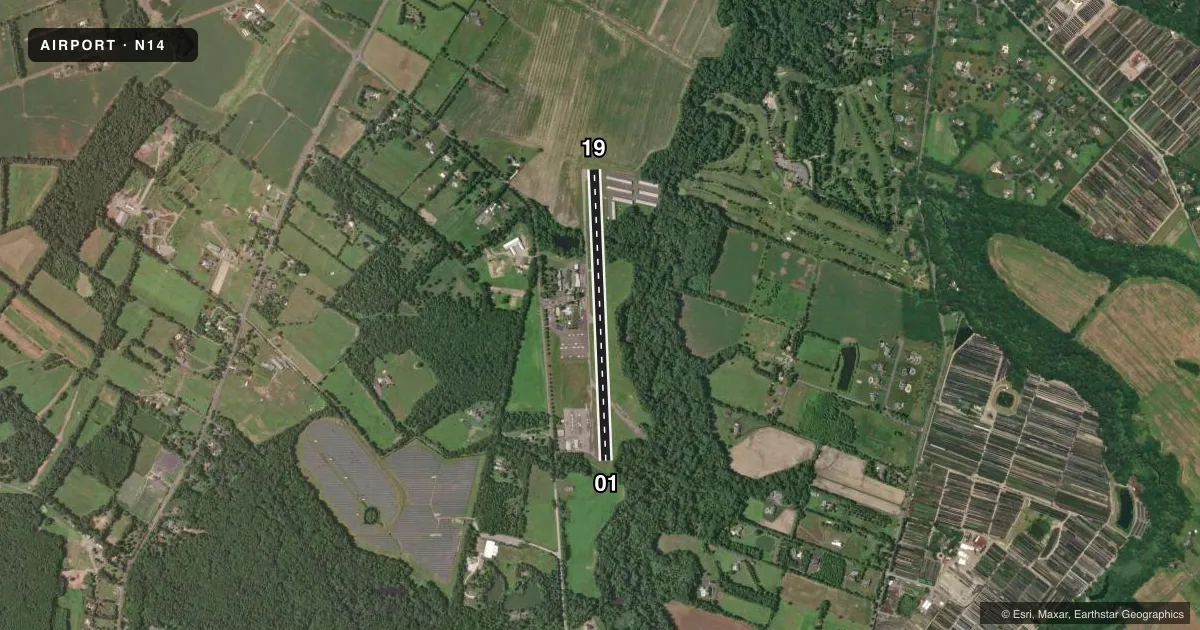
Airport sketch
Runways drawn to scale from FAA survey coordinates, rendered over satellite imagery. Not for navigation.
Approaches & charts
Services on the field
Fuel grades, oxygen, maintenance, ramp storage and lighting — as declared to the FAA by the airport operator.
Fuel & services
- Fuel
- 100LLA
- Oxygen (bottled)
- Not available
- Oxygen (bulk)
- Not available
- Airframe repair
- Minor
- Power plant repair
- Minor
- Other services
- INSTR,RNTL
Ramp & ground
- Transient storage
- Tie-down
- Landing fee
- No fee published
- Lighting schedule
- SEE RMK
- Beacon schedule
- SS-SR
- Beacon
- White / Green (civil land)(WG)
- Wind indicator
- Lighted
- Segmented circle
- Yes
Fuel & FBOs
Cheapest 100LL and Jet A on the field and nearby. Always confirm with the FBO before taxi.
Airport notes
Surface conditions, obstructions, local procedures, lighting outages and other notes published with each FAA cycle.
General notes
- EAST-WEST RAVINE CROSSES EXTD CNTRLN RWY 01, 100 FT FM THLD.
- DEEP RETENTION POND 23 FT WEST OF PARALLEL TWY CNTRLN, NORTH OF OPS BLDG.
- FOR CD CTC MC GUIRE APCH AT 609-754-2767.
- DEER & BIRDS ON & INVOF ARPT.
Lighting notes
- ACTVT MIRL, PAPI, REIL AND TWY LGTS - CTAF.
Approach & departure obstructions
- 01TREE, +42 FT HIGH, 43 FT FM THLD, 102 FT R.
- 01REILS INOP.
- 19REILS INOP.
VFR map & nearby airports
VFR sectional. Tap any ICAO chip to open that airport.
Key facts · N14
Answer card- ICAO
- N14
- Name
- FLYING W
- Location
- LUMBERTON, NEW JERSEY
- Elevation
- 49.3 ft MSL
- Traffic pattern altitude
- 1,049.3 ft MSL (1,000 AGL)
- Control tower
- Non-towered (use CTAF)
- Total runways
- 1
- Longest runway
- 01/19 · 3,496 ft
- Published ILS approaches
- 0
- Published frequencies
- 4
- Magnetic variation
- 13°
- Current flight rules
- VFR
- Current wind
- Calm / unavailable
- Favored runway now
- –
Flying W Airport is in Lumberton, New Jersey. Field elevation is 49.3 ft MSL. The airport has one runway, 01/19, which is 3,496 ft long and asphalt. There is no control tower. Pattern altitude is not published, so use the standard 1,000 ft AGL for light piston traffic unless current instructions say otherwise. No ILS approaches are published here.
The on-field FBO is Flying W Airport. It carries AVGAS 100LL and Jet A. Call the FBO directly at (609) 267-7673 for current service details before you go.
A few remarks matter for planning. There is a tree more than 42 ft high near the threshold of runway 01. An east-west ravine crosses the extended centerline of runway 01 about 100 ft from the threshold. Deer and birds are reported on and near the airport. Runway end identifier lights are inoperative on both ends. Activated runway lights, the PAPI and taxiway lights are controlled by CTAF. For clearance delivery, contact Mc Guire Approach at 609-754-2767. First-time visitors should also review the current Chart Supplement for any local procedures. Then brief the short field length, the non-towered pattern and the nearby obstacles before arrival.