METAR & TAF KPNE
Current METAR
Observed 11:54Z
KPNE 271154Z 26006KT 10SM FEW120 23/19 A2986 RMK AO2 SLP110 T02280189 10228 20211 53008 $
- Wind
- 260° @ 6 kt
- Visibility
- 10 SM
- Temp / Dew
- 23°C / 19°C
- Altimeter
- 29.86 inHg
- Clouds
- FEW
- Density alt
- 1,183 ft
- Ceiling
- Unlimited
- Rules
- VFR
Airport info & contacts
Manager on record, flight service, ARTCC, attendance schedule and pattern altitude — published by the FAA and refreshed every 28 days.
Location
- From city
- 10 NM NE
- VFR sectional
- NEW YORK
- ARTCC
- ZNY · NEW YORK
- NOTAM facility
- PNE (NOTAM-D)
Airport manager
- Name
- JOHN BREWER
- Phone
- 215-937-7968
- Address
- 9800 ASHTON ROAD, PHILADELPHIA PA 19114
Flight service · Hours
- FSS IPT
- WILLIAMSPORT1-800-WX-BRIEF
- Attendance
- ALL
Frequencies
Tap any row to copy the frequency to your clipboard.
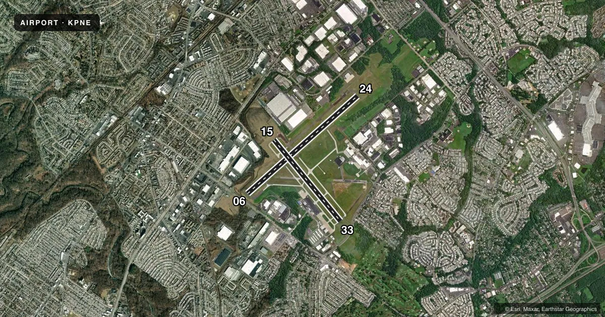
Runways & pattern
Full pagePattern entry · RWY 24
LEFT TRAFFIC| Runway | Heading (°M) | Length | Surface | Traffic |
|---|---|---|---|---|
| 06/24Favored | 36° / 216° | 7,000 ft | ASPH | Standard L |
| 15/33 | 129° / 309° | 4,999 ft | ASPH | Standard L |
Runway end performance
| End | TORA | TODA | ASDA | LDA | VGSI | Approach lights | Obstruction |
|---|---|---|---|---|---|---|---|
| 06 | 7,000' | 7,000' | 7,000' | 6,502' | PAPI 4-box left(3°) | — | 59', trees, 1524' from thr, 372' R of cntrln, slope 22 |
| 24 | 6,826' | 7,000' | 6,102' | 6,102' | PAPI 4-box right(3°) | MALSR | 68', trees, 2273' from thr, 769' R of cntrln, slope 30 |
| 15 | — | — | — | — | PAPI 4-box left(3°) | — | 41', tree, 1023' from thr, 4' R of cntrln, slope 20 |
| 33 | — | — | — | — | PAPI 4-box left(3°) | — | 44', tree, 1472' from thr, 296' R of cntrln, slope 28 |
Declared distances in feet. TORA = takeoff run available, TODA = takeoff distance, ASDA = accelerate-stop, LDA = landing distance.
Airport sketch
Runways drawn to scale from FAA survey coordinates, rendered over satellite imagery. Not for navigation.
Approaches & charts
ILS · 1
Services on the field
Fuel grades, oxygen, maintenance, ramp storage and lighting — as declared to the FAA by the airport operator.
Fuel & services
- Fuel
- 100LLA
- Oxygen (bottled)
- HIGH/LOW
- Oxygen (bulk)
- High pressure
- Airframe repair
- Major
- Power plant repair
- Major
- Other services
- AFRT,AMB,AVNCS,CARGO,CHTR,INSTR,RNTL,SALES,SURV
Ramp & ground
- Transient storage
- Tie-down
- Hangar
- Landing fee
- Yes
- Customs
- Not available
- Lighting schedule
- SEE RMK
- Beacon schedule
- SS-SR
- Beacon
- White / Green (civil land)(WG)
- Wind indicator
- Lighted
- Segmented circle
- No
Fuel & FBOs
Cheapest 100LL and Jet A on the field and nearby. Always confirm with the FBO before taxi.
Airport notes
Surface conditions, obstructions, local procedures, lighting outages and other notes published with each FAA cycle.
General notes
- TURBOJET ACFT ARE CONFINED TO FULL LENGTH RWY 6/24 UNLESS STRONG WINDS DICTATE OTHERWISE.
- RWY 15 IS NOISE SENSITIVE. RWY 15 ARRIVALS ARE REQUESTED TO FLY AT OR ABOVE GLIDE PATH.
- ARPT CLSD TO PART 121 AIR CARRIER AND PART 135 SCHEDULED SVC.
- DEER & BIRDS ON & INVOF ARPT.
- TPA ACFT LESS THAN 12500 LBS 1120 MSL; ACFT 12500 LBS OR MORE & ALL TURBOJET & TURBINE PWRD ACFT 1620 MSL; ROTARY WING ACFT 920 MSL.
- BE ALERT FOR ARPT VEHICLES WHEN TWR CLSD.
- BE ALERT: 3 LARGE BRIGHTLY LIT JUMBOTRON SIGNS APRX 3 MILES NE OF AER 24. THESE SIGNS MAY CAUSE VISUAL ILLUSIONS DURING AN APCH OR MISSED APCH. PILOTS BE AT ADVISED.
- FOR CD WHEN ATCT IS CLSD CTC PHL APCH AT (800) 354-9884.
- TWY L3 SAFETY AREA NON STD.
- TWY J1 NON MOVEMENT AREA.
- COMPASS ROSE NOT FOR PUB USE.
- TWY J BTN TWY G AND HEL APN IS NON MOV AREA.
- LMT TGL OPNS TO 0900-2200 MON-SAT AND 1200-2200 SUN; 5 PER FLT FOR NOISE ABATEMENT.
Lighting notes
- WHEN ATCT CLSD HIRL RWY 06/24 PRESET MED INTST, TO INCRS INTST AND ACTVT MALSR RWY 24 - CTAF
Other notes
- CBP 24 HR PPR BY CALLING (215) 594-4272 OR (215) 594-4141.
VFR map & nearby airports
VFR sectional. Tap any ICAO chip to open that airport.
Key facts · KPNE
Answer card- ICAO
- KPNE
- Name
- NORTHEAST PHILADELPHIA
- Location
- PHILADELPHIA, PENNSYLVANIA
- Elevation
- 119.8 ft MSL
- Traffic pattern altitude
- 1,119.8 ft MSL (1,000 AGL)
- Control tower
- Towered · 0600-2300
- Total runways
- 2
- Longest runway
- 06/24 · 7,000 ft
- Published ILS approaches
- 1
- Published frequencies
- 9
- Magnetic variation
- 12°
- Current flight rules
- VFR
- Current wind
- 260° at 6 kt
- Favored runway now
- RWY 24
Northeast Philadelphia Airport is in Philadelphia, Pennsylvania. The field elevation is 119.8 ft MSL. KPNE has two asphalt runways. The longest is 7,000 ft on runway 06/24. The airport has a control tower. Tower hours are 0600-2300. Runway 24 has the published ILS approach.
For pattern work, the published traffic pattern altitude for aircraft less than 12,500 pounds is 1,120 ft MSL. Aircraft 12,500 pounds or more use 1,620 ft MSL. Rotary wing aircraft use 920 ft MSL. Atlantic Aviation is on the field. It carries 100LL and Jet A. Call the FBO directly at (215) 698-3100 for current service details.
This is a busy Philadelphia-area airport, so expect close ATC coordination and local traffic. Published remarks call out noise-sensitive operations on runway 15. Arrivals on 15 are requested to stay at or above the glide path. Limited touch-and-go operations are allowed. The airport also notes deer and birds in the area. Three bright jumbotron signs sit about 3 miles northeast of runway 24. They can create visual illusions on approach or missed approach. When the tower is closed, get clearance delivery through Philadelphia Approach. Check the current FAA Chart Supplement for any current restrictions before you go.