METAR & TAF N81
N81 does not publish a METAR.
Showing the nearest reporting station: KACY (ATLANTIC CITY INTL) · 15.1 NM away. Conditions at N81 may differ.
METAR · KACY
Observed 12:54Z
KACY 271254Z 24004KT 10SM BKN046 24/18 A2986 RMK AO2 SLP111 T02390178
- Wind
- 240° @ 4 kt
- Visibility
- 10 SM
- Temp / Dew
- 24°C / 18°C
- Altimeter
- 29.86 inHg
- Clouds
- BKN
- Density alt
- 1,235 ft
- Ceiling
- 4,600 ft AGL
- Rules
- VFR
Airport info & contacts
Manager on record, flight service, ARTCC, attendance schedule and pattern altitude — published by the FAA and refreshed every 28 days.
Location
- From city
- 3 NM NE
- VFR sectional
- WASHINGTON
- ARTCC
- ZDC · WASHINGTON
- NOTAM facility
- MIV (NOTAM-D)
Airport manager
- Name
- FRANK ZUBER
- Phone
- (609) 567-4300
- Address
- TOWN HALL, 100 CENTRAL AVENUE, HAMMONTON NJ 08037
Flight service · Hours
- FSS MIV
- MILLVILLE1-800-WX-BRIEF
- Attendance
- 0800-DUSK
Frequencies
Tap any row to copy the frequency to your clipboard.
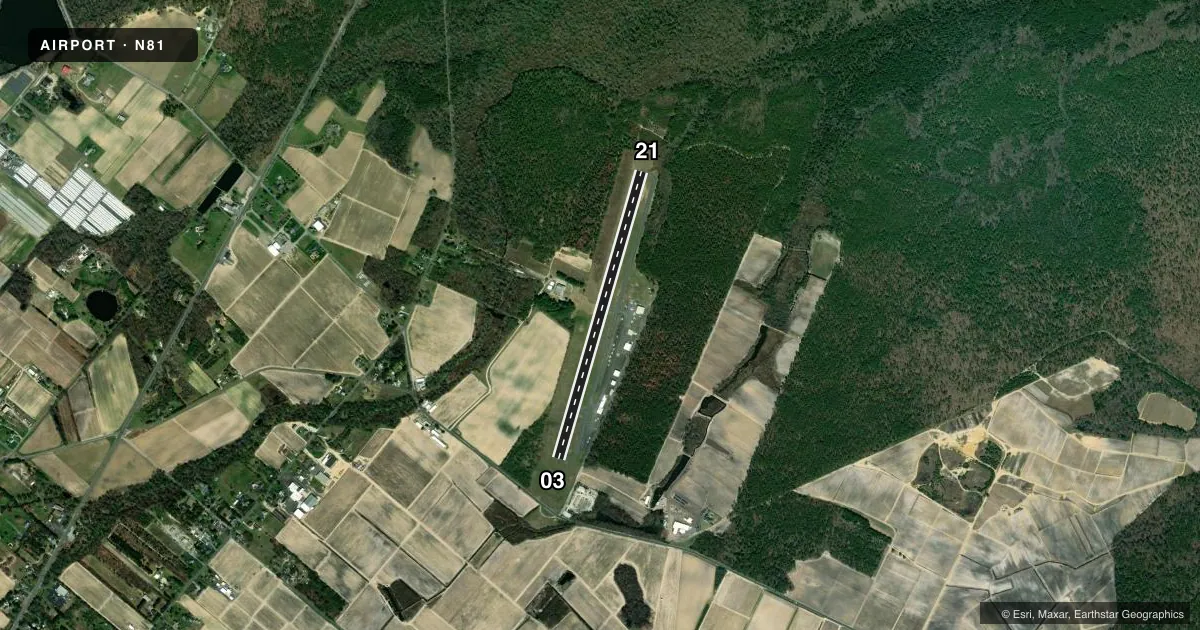
Runways & pattern
Full pagePattern entry · RWY 21
LEFT TRAFFICRunway end performance
| End | TORA | TODA | ASDA | LDA | VGSI | Approach lights | Obstruction |
|---|---|---|---|---|---|---|---|
| 03 | — | — | — | — | PAPI 2-box left(3.5°) | — | 61', trees, 725' from thr, 270' R of cntrln, slope 8 |
| 21 | — | — | — | — | PAPI 2-box left(3.25°) | — | 40', trees, 210' from thr, 150' R of cntrln, slope 0 |
Declared distances in feet. TORA = takeoff run available, TODA = takeoff distance, ASDA = accelerate-stop, LDA = landing distance.
Airport sketch
Runways drawn to scale from FAA survey coordinates, rendered over satellite imagery. Not for navigation.
Approaches & charts
Services on the field
Fuel grades, oxygen, maintenance, ramp storage and lighting — as declared to the FAA by the airport operator.
Fuel & services
- Fuel
- 100LLA
- Oxygen (bottled)
- Not available
- Oxygen (bulk)
- Not available
- Airframe repair
- Major
- Power plant repair
- Major
- Other services
- AMB,INSTR,RNTL
Ramp & ground
- Transient storage
- Tie-down
- Hangar
- Landing fee
- No fee published
- Customs
- Not available
- Lighting schedule
- SEE RMK
- Beacon schedule
- SS-SR
- Beacon
- White / Green (civil land)(WG)
- Wind indicator
- Lighted
- Segmented circle
- No
Fuel & FBOs
Cheapest 100LL and Jet A on the field and nearby. Always confirm with the FBO before taxi.
Airport notes
Surface conditions, obstructions, local procedures, lighting outages and other notes published with each FAA cycle.
General notes
- ON ARPT MAINT CTC 609-567-5300.
- RWY 03; PARALLEL DITCH FIRST 500 FT OF RWY R SIDE WITHIN 100 FT OF CTLN.
- DEER & BIRDS ON & INVOF ARPT.
- GCO AVBL ON FREQ 121.725.
Lighting notes
- ACTVT REIL RWY 03 & 21; MIRL RWY 03/21 - 123.5. VGSI CONS.
Approach & departure obstructions
- 03+30 FT TREES 190-240 FT L 70-170 FT FROM THLD.
- 21+50 FT TREES 150 FT R 0-200 FT FROM THLD.
- 03TALL TREES ON APCH.
Other notes
- AUTOMATED UNICOM; 3 CLICKS WX ADZY.
- MANAGEREXT 121.
- OWNEREXT 121.
VFR map & nearby airports
VFR sectional. Tap any ICAO chip to open that airport.
Key facts · N81
Answer card- ICAO
- N81
- Name
- HAMMONTON MUNI
- Location
- HAMMONTON, NEW JERSEY
- Elevation
- 64.6 ft MSL
- Traffic pattern altitude
- 1,064.6 ft MSL (1,000 AGL)
- Control tower
- Non-towered (use CTAF)
- Total runways
- 1
- Longest runway
- 03/21 · 3,601 ft
- Published ILS approaches
- 0
- Published frequencies
- 4
- Magnetic variation
- 13°
- Current flight rules
- VFR
- Current wind
- 240° at 4 kt
- Favored runway now
- RWY 21
Hammonton Muni sits in Hammonton, New Jersey. Field elevation is 64.6 ft MSL. The airport has one runway. Runway 03/21 is 3,601 ft long with an asphalt surface. There is no control tower. CTAF and UNICOM are both 122.7. Approach and departure service is published on 134.25 and 292.2 through Atlantic City. No ILS approaches are published here.
Pattern altitude is not published. Use 1,000 ft AGL for light piston traffic unless the current Chart Supplement says otherwise. The runway lighting is useful after dark. Runway 03 and 21 have REILs. Runway 03/21 also has medium intensity runway lights. Visual glide slope indicators are installed. Lighting is controlled on 123.5. Automated UNICOM is available with three clicks for a weather advisory.
This is a field where the trees matter. There are tall trees on the approach to runway 03. There are also 30-foot trees left of the runway 03 threshold area. Runway 21 has 50-foot trees right of the threshold area. Runway 03 also has a parallel ditch along the first 500 feet on the right side, within 100 feet of centerline. Deer and birds are reported on and near the airport. No on-field FBOs are listed, so call the airport operator or the field directly before you go if you need fuel or ramp details.