METAR & TAF KMJX
Current METAR
Observed 09:56Z
KMJX 270956Z AUTO 00000KT 10SM CLR 19/17 A2985 RMK AO2 SLP111 T01890167 $
- Wind
- 000° @ 0 kt
- Visibility
- 10 SM
- Temp / Dew
- 19°C / 17°C
- Altimeter
- 29.85 inHg
- Clouds
- CLR
- Density alt
- 673 ft
- Ceiling
- Unlimited
- Rules
- VFR
Airport info & contacts
Manager on record, flight service, ARTCC, attendance schedule and pattern altitude — published by the FAA and refreshed every 28 days.
Location
- From city
- 5 NM SW
- VFR sectional
- WASHINGTON
- ARTCC
- ZNY · NEW YORK
- NOTAM facility
- MJX (NOTAM-D)
Airport manager
- Name
- ANTHONY AGLIATA
- Phone
- (732) 929-2054
- Address
- 129 HOOPER AVENUE, PO BOX 2191, TOMS RIVER NJ 08754-2191
Flight service · Hours
- FSS MIV
- MILLVILLE1-800-WX-BRIEF
- Attendance
- NOV - MAR · 0800-1700
- APR - OCT · 0800-2000
Frequencies
Tap any row to copy the frequency to your clipboard.
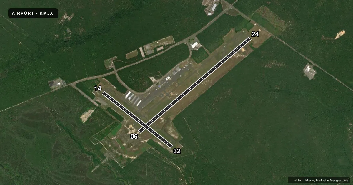
Runways & pattern
Full pagePattern entry · RWY 06
LEFT TRAFFIC| Runway | Heading (°M) | Length | Surface | Traffic |
|---|---|---|---|---|
| 06/24 | 37° / 217° | 5,950 ft | ASPH | Standard L |
| 14/32 | 115° / 295° | 3,599 ft | ASPH | Standard L |
Runway end performance
| End | TORA | TODA | ASDA | LDA | VGSI | Approach lights | Obstruction |
|---|---|---|---|---|---|---|---|
| 06 | 5,950' | 5,950' | 5,835' | 5,835' | PAPI 2-box left(3°) | MALSR | — |
| 24 | 5,950' | 5,950' | 5,950' | 5,835' | PAPI 2-box left(3°) | — | — |
| 14 | — | — | — | — | PAPI 2-box left(3°) | — | — |
| 32 | — | — | — | — | PAPI 2-box left(3°) | — | — |
Declared distances in feet. TORA = takeoff run available, TODA = takeoff distance, ASDA = accelerate-stop, LDA = landing distance.
Airport sketch
Runways drawn to scale from FAA survey coordinates, rendered over satellite imagery. Not for navigation.
Approaches & charts
ILS · 1
Services on the field
Fuel grades, oxygen, maintenance, ramp storage and lighting — as declared to the FAA by the airport operator.
Fuel & services
- Fuel
- 100LLA
- Oxygen (bottled)
- High pressure
- Oxygen (bulk)
- Not available
- Airframe repair
- Major
- Power plant repair
- Major
- Other services
- AMB,AVNCS,INSTR,RNTL,SALES
Ramp & ground
- Transient storage
- Tie-down
- Hangar
- Landing fee
- No fee published
- Customs
- Not available
- Lighting schedule
- SEE RMK
- Beacon schedule
- SS-SR
- Beacon
- White / Green (civil land)(WG)
- Wind indicator
- Lighted
- Segmented circle
- Yes
Fuel & FBOs
Cheapest 100LL and Jet A on the field and nearby. Always confirm with the FBO before taxi.
Airport notes
Surface conditions, obstructions, local procedures, lighting outages and other notes published with each FAA cycle.
General notes
- DEER & BIRDS ON & INVOF ARPT.
- FOR CD CTC MC GUIRE APCH AT 609-754-2767.
Lighting notes
- ACTVT MALSR RWY 06; REIL RWY 14, 32 & 24; PAPI RWY 06, 24, 14 & 32; HIRL RWY 06/24; MIRL RWY 14/32 - CTAF.
Runway surface & condition
- H1FATO 100X100 FT
Other notes
- 1UNATNDD CHRISTMAS & NEW YEARS DAY. PREARRANGE FOR SVCS AFT HRS CALL 732-797-1077.
VFR map & nearby airports
VFR sectional. Tap any ICAO chip to open that airport.
Key facts · KMJX
Answer card- ICAO
- KMJX
- Name
- OCEAN COUNTY
- Location
- TOMS RIVER, NEW JERSEY
- Elevation
- 86 ft MSL
- Traffic pattern altitude
- 1,086 ft MSL (1,000 AGL)
- Control tower
- Non-towered (use CTAF)
- Total runways
- 2
- Longest runway
- 06/24 · 5,950 ft
- Published ILS approaches
- 1
- Published frequencies
- 4
- Magnetic variation
- 13°
- Current flight rules
- VFR
- Current wind
- 000° at 0 kt
- Favored runway now
- –
Ocean County Airport sits in Toms River, New Jersey. Field elevation is 86 ft MSL. It has two asphalt runways. The longest is 06/24 at 5,950 ft. The other runway is 14/32 at 3,599 ft. There is no control tower. Use CTAF 122.7. The airport uses McGuire Approach for clearance and approach services on 126.475 and 363.8. One ILS is published for runway 06. Pattern altitude is not published. For light piston operations, use 1,000 ft AGL unless current published data says otherwise. That puts the pattern near 1,086 ft MSL.
Ocean Aire is on the field. It carries 100LL and Jet A. Call ahead at (732) 797-1077 if you need after-hours service. The published remarks also note MALSR on runway 06. High intensity lights are on 06/24. Medium intensity lights are on 14/32. PAPI is on all runway ends. Deer and birds are reported on and near the airport. Keep a sharp scan on arrival and departure. The airport is unattended on Christmas and New Year's Day. Final approach and takeoff area is 100 by 100 feet. For a first-time arrival, the main things to plan for are the non-towered pattern, the McGuire handoff and wildlife on the field.