METAR & TAF N12
N12 does not publish a METAR.
Showing the nearest reporting station: KBLM (MONMOUTH EXEC) · 7.6 NM away. Conditions at N12 may differ.
METAR · KBLM
Observed 00:29Z
KBLM 040029Z AUTO 34031G43KT 6SM VCTS HZ SQ SCT075 BKN120 34/19 A2998 RMK AO2 PK WND 33043/0027 LTG DSNT W-NE TSB29 PRESRR PNO $
- Wind
- 340° @ 31G43 kt
- Visibility
- 6 SM
- Temp / Dew
- 34°C / 19°C
- Altimeter
- 29.98 inHg
- Clouds
- BKN
- Density alt
- 2,258 ft
- Ceiling
- 12,000 ft AGL
- Rules
- VFR
Airport info & contacts
Manager on record, flight service, ARTCC, attendance schedule and pattern altitude — published by the FAA and refreshed every 28 days.
Location
- From city
- 3 NM SE
- VFR sectional
- NEW YORK
- ARTCC
- ZNY · NEW YORK
- NOTAM facility
- MIV (NOTAM-D)
Airport manager
- Name
- STEVE REINMAN
- Phone
- 732-363-6400
- Address
- 231 THIRD STREET, LAKEWOOD NJ 08701
Flight service · Hours
- FSS MIV
- MILLVILLE1-800-WX-BRIEF
- Attendance
- MAY-OCT · 0800-2000
- NOV-APR · 0800-1800
Frequencies
Tap any row to copy the frequency to your clipboard.
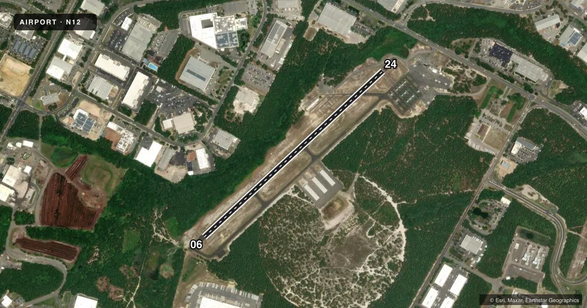
Runways & pattern
Full pagePattern entry · RWY 06
LEFT TRAFFICRunway end performance
| End | TORA | TODA | ASDA | LDA | VGSI | Approach lights | Obstruction |
|---|---|---|---|---|---|---|---|
| 06 | — | — | — | — | PAPI 2-box right(3°) | — | 10', trees, 258' from thr, 134' R of cntrln, slope 5 |
| 24 | — | — | — | — | PAPI 2-box left(3°) | — | 10', road, 200' from thr, 60' R of cntrln, slope 0 |
Declared distances in feet. TORA = takeoff run available, TODA = takeoff distance, ASDA = accelerate-stop, LDA = landing distance.
Airport sketch
Runways drawn to scale from FAA survey coordinates, rendered over satellite imagery. Not for navigation.
Approaches & charts
Services on the field
Fuel grades, oxygen, maintenance, ramp storage and lighting — as declared to the FAA by the airport operator.
Fuel & services
- Fuel
- 100LL
- Oxygen (bottled)
- Not available
- Oxygen (bulk)
- Not available
- Airframe repair
- Major
- Power plant repair
- Major
- Other services
- CHTR,INSTR,PAJA,RNTL,SALES
Ramp & ground
- Transient storage
- Tie-down
- Landing fee
- No fee published
- Customs
- Not available
- Lighting schedule
- SEE RMK
- Beacon schedule
- SS-SR
- Beacon
- White / Green (civil land)(WG)
- Wind indicator
- Lighted
- Segmented circle
- No
Fuel & FBOs
Cheapest 100LL and Jet A on the field and nearby. Always confirm with the FBO before taxi.
Airport notes
Surface conditions, obstructions, local procedures, lighting outages and other notes published with each FAA cycle.
General notes
- GCO AVBL ON FREQ 121.725 THRU MCGUIRE APCH CTL. IF UNAVBL CTC MC GUIRE APCH AT 609-754-2767.
- HEAVY BANNER TOWING OPS APR-OCT.
- DEER ON AND INVOF OF ARPT.
- FOR CD USE GCO 121.725, IF UNA CTC MC GUIRE APCH AT 609-754-2767.
Lighting notes
- ACTVT PAPI RWY 06 & 24; MIRL RWY 06/24 - CTAF.
Approach & departure obstructions
- 24RY 24 10 FT ROAD AT RY END 120 FT R CNTRLN.
- 06RY 06 HAS APCH RATIO 52:1 TO DSPLCD THLD.
Other notes
- 2SVCS AVBL AFT HRS CALL 732-533-3062.
- MANAGERALT 732-533-3062.
VFR map & nearby airports
VFR sectional. Tap any ICAO chip to open that airport.
Key facts · N12
Answer card- ICAO
- N12
- Name
- LAKEWOOD
- Location
- LAKEWOOD, NEW JERSEY
- Elevation
- 41.9 ft MSL
- Traffic pattern altitude
- 1,041.9 ft MSL (1,000 AGL)
- Control tower
- Non-towered (use CTAF)
- Total runways
- 1
- Longest runway
- 06/24 · 2,987 ft
- Published ILS approaches
- 0
- Published frequencies
- 4
- Magnetic variation
- 13°
- Current flight rules
- VFR
- Current wind
- 340° at 31 kt
- Favored runway now
- RWY 06
Lakewood Airport (N12) sits in Lakewood, New Jersey. Field elevation is 41.9 ft MSL. It has one runway, 06/24, which is 2,987 ft long with an asphalt surface. There is no control tower. The airport uses CTAF 122.8. No ILS approaches are published here.
Pattern altitude is not published. Use 1,000 ft AGL for light piston traffic unless the current Chart Supplement says otherwise. The field is in a busy part of New Jersey, so expect local traffic, deer near the airport. Heavy banner towing also runs from April through October. Runway 06 has a displaced-threshold approach note. Runway 24 has a road near the end, 120 ft right of centerline. The runway lights are controlled on the CTAF. The PAPI for 06 and 24 is also activated from the field.
Aviation Charters Patrol Service is on the field. It carries AVGAS 100LL. For clearance delivery, use the ground communications outlet on 121.725. If that is unavailable, contact McGuire Approach. The airport manager also has an alternate phone number listed in the Chart Supplement. For any current noise, access, or after-hours details, check the current FAA Chart Supplement or call the airport operator directly before you go.