METAR & TAF N87
N87 does not publish a METAR.
Showing the nearest reporting station: KTTN (TRENTON MERCER) · 10.4 NM away. Conditions at N87 may differ.
METAR · KTTN
Observed 22:53Z
KTTN 262253Z 17005KT 10SM OVC070 27/13 A2983 RMK AO2 SLP094 T02720128 $
- Wind
- 170° @ 5 kt
- Visibility
- 10 SM
- Temp / Dew
- 27°C / 13°C
- Altimeter
- 29.83 inHg
- Clouds
- OVC
- Density alt
- 1,698 ft
- Ceiling
- 7,000 ft AGL
- Rules
- VFR
Airport info & contacts
Manager on record, flight service, ARTCC, attendance schedule and pattern altitude — published by the FAA and refreshed every 28 days.
Location
- From city
- 1 NM E
- VFR sectional
- NEW YORK
- ARTCC
- ZNY · NEW YORK
- NOTAM facility
- MIV (NOTAM-D)
Airport manager
- Name
- MICHAEL SANTERIAN
- Phone
- 609-259-1059
- Address
- 106B SHARON ROAD, ROBBINSVILLE NJ 08691
Flight service · Hours
- FSS MIV
- MILLVILLE1-800-WX-BRIEF
- Attendance
- 0800-1600
Frequencies
Tap any row to copy the frequency to your clipboard.
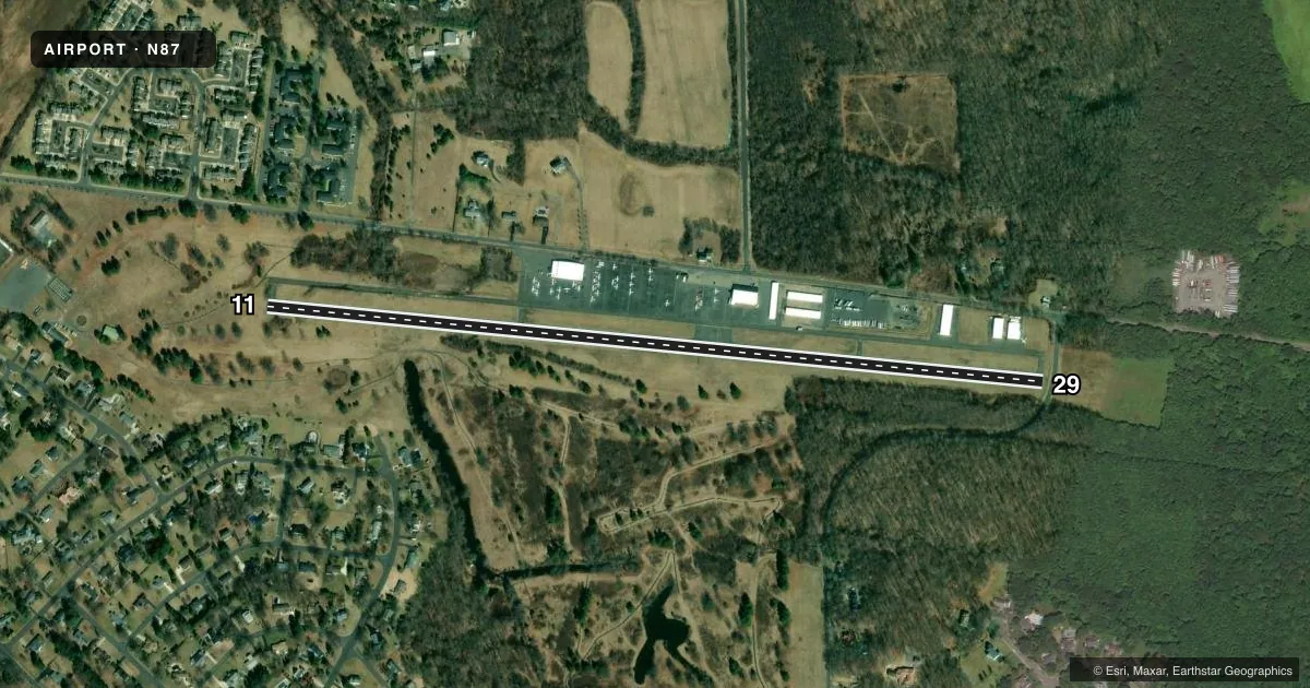
Runways & pattern
Full pagePattern entry · RWY 11
LEFT TRAFFICRunway end performance
| End | TORA | TODA | ASDA | LDA | VGSI | Approach lights | Obstruction |
|---|---|---|---|---|---|---|---|
| 11 | — | — | — | — | PAPI 2-box left(4.5°) | — | 74', trees, 250' from thr, 195' R of cntrln, slope 0 |
| 29 | — | — | — | — | PAPI 2-box right(4°) | — | 60', trees, 200' from thr, 176' R of cntrln, slope 0 |
Declared distances in feet. TORA = takeoff run available, TODA = takeoff distance, ASDA = accelerate-stop, LDA = landing distance.
Airport sketch
Runways drawn to scale from FAA survey coordinates, rendered over satellite imagery. Not for navigation.
Approaches & charts
Services on the field
Fuel grades, oxygen, maintenance, ramp storage and lighting — as declared to the FAA by the airport operator.
Fuel & services
- Fuel
- 100LL
- Airframe repair
- Major
- Power plant repair
- Major
- Other services
- CHTR,INSTR,RNTL
Ramp & ground
- Transient storage
- Tie-down
- Hangar
- Landing fee
- No fee published
- Customs
- Not available
- Lighting schedule
- SEE RMK
- Beacon schedule
- SS-SR
- Beacon
- White / Green (civil land)(WG)
- Wind indicator
- Lighted
- Segmented circle
- Yes
Fuel & FBOs
Cheapest 100LL and Jet A on the field and nearby. Always confirm with the FBO before taxi.
Airport notes
Surface conditions, obstructions, local procedures, lighting outages and other notes published with each FAA cycle.
General notes
- VFR DEP RY 29; FOR NOISE ABATEMEMT CLIMB STRAIGHT AHEAD UNTIL REACHING 700 FT AGL BEFORE TURNING.
- VFR DEP RY 11 AVOID OVERFLIGHT OF SHARON ELEMENTARY SCHOOL .75 NM NORTHEAST.
- FOR CD CTC MC GUIRE APCH AT 609-754-2767.
- DEER & BIRDS ON & INVOF ARPT.
- TWY & RAMP AREAS HAVE MULT TRANSVERSE AND PARL CRACKS.
Lighting notes
- ACTVT MIRL RY 11/29 - 123.3.
Fuel notes
- 100LLSELF SVC FUEL SYS MID-FIELD APRON.
Approach & departure obstructions
- 29RY 29 ROAD WITH 15 FT VEHICLES 40 FR FM RY END CROSSING CNTRLN.
- 11RWY 11 APCH SLOPE 8:1 TO DSPLCD THLD.
Other notes
- BUILT IN 1945.
- WIND INDICATOR OTS INDEFLY.
- 11/29NMRS TRANSVERSE & PARL CRACKS ALONG RWY.
VFR map & nearby airports
VFR sectional. Tap any ICAO chip to open that airport.
Key facts · N87
Answer card- ICAO
- N87
- Name
- TRENTON-ROBBINSVILLE
- Location
- ROBBINSVILLE, NEW JERSEY
- Elevation
- 118 ft MSL
- Traffic pattern altitude
- 1,118 ft MSL (1,000 AGL)
- Control tower
- Non-towered (use CTAF)
- Total runways
- 1
- Longest runway
- 11/29 · 4,275 ft
- Published ILS approaches
- 0
- Published frequencies
- 4
- Magnetic variation
- 13°
- Current flight rules
- VFR
- Current wind
- 170° at 5 kt
- Favored runway now
- RWY 11
Trenton-Robbinsville Airport sits in Robbinsville, New Jersey. Field elevation is 118 ft MSL. The airport has one runway. Runway 11/29 is 4,275 ft long and asphalt. There is no control tower. No ILS approaches are published here. Pattern altitude is not published, so use the standard 1,000 ft AGL for light piston traffic unless the current Chart Supplement says otherwise.
The on-field FBO is Trenton-Robbinsville Airport. It carries AVGAS 100LL. Self-serve 100LL is available on the mid-field apron. The runway lights on 11/29 are medium intensity and are activated on 123.3. McGuire Approach handles clearance delivery. Published remarks also call out runway and pavement cracking, so expect a rougher surface than a freshly paved field.
There are a few operational items worth planning for. Runway 29 has a road close off the departure end with vehicles crossing near the centerline. Runway 11 has a displaced-threshold slope note. For VFR departure on runway 29, climb straight ahead to 700 ft AGL before turning for noise abatement. For runway 11 departures, avoid overflying Sharon Elementary School northeast of the field. Deer and birds are reported on and near the airport. The wind indicator is out of service indefinitely, so verify winds before you commit to the landing or departure.