METAR & TAF 39N
39N does not publish a METAR.
Showing the nearest reporting station: KTTN (TRENTON MERCER) · 10.2 NM away. Conditions at 39N may differ.
METAR · KTTN
Observed 03:53Z
KTTN 270353Z AUTO 18004KT 10SM CLR 21/17 A2986 RMK AO2 SLP103 T02110167 $
- Wind
- 180° @ 4 kt
- Visibility
- 10 SM
- Temp / Dew
- 21°C / 17°C
- Altimeter
- 29.86 inHg
- Clouds
- CLR
- Density alt
- 953 ft
- Ceiling
- Unlimited
- Rules
- VFR
Airport info & contacts
Manager on record, flight service, ARTCC, attendance schedule and pattern altitude — published by the FAA and refreshed every 28 days.
Location
- From city
- 3 NM N
- VFR sectional
- NEW YORK
- ARTCC
- ZNY · NEW YORK
- NOTAM facility
- MIV (NOTAM-D)
Airport manager
- Name
- KENNETH NIERENBERG
- Phone
- 609-921-3100
- Address
- PRINCETON ARPT 41 AIRPARK RD, PRINCETON NJ 08540
Flight service · Hours
- FSS MIV
- MILLVILLE1-800-WX-BRIEF
- Attendance
- 0800-DUSK
Frequencies
Tap any row to copy the frequency to your clipboard.
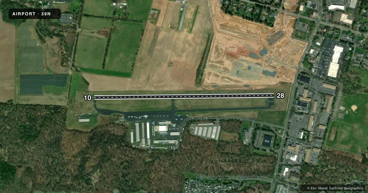
Runways & pattern
Full pagePattern entry · RWY 28
LEFT TRAFFICRunway end performance
| End | TORA | TODA | ASDA | LDA | VGSI | Approach lights | Obstruction |
|---|---|---|---|---|---|---|---|
| 10 | — | — | — | — | PAPI 2-box left(3.45°) | — | 44', tree, 1503' from thr, 124' R of cntrln, slope 29 |
| 28 | — | — | — | — | PAPI 2-box left(3°) | — | 41', bldg, 528' from thr, 55' R of cntrln, slope 8 |
Declared distances in feet. TORA = takeoff run available, TODA = takeoff distance, ASDA = accelerate-stop, LDA = landing distance.
Airport sketch
Runways drawn to scale from FAA survey coordinates, rendered over satellite imagery. Not for navigation.
Approaches & charts
Services on the field
Fuel grades, oxygen, maintenance, ramp storage and lighting — as declared to the FAA by the airport operator.
Fuel & services
- Fuel
- 100LLA
- Oxygen (bottled)
- Not available
- Oxygen (bulk)
- Not available
- Airframe repair
- Major
- Power plant repair
- Major
- Other services
- AVNCS,CHTR,INSTR,RNTL,SALES
Ramp & ground
- Transient storage
- Tie-down
- Hangar
- Landing fee
- Yes
- Customs
- Not available
- Lighting schedule
- SEE RMK
- Beacon schedule
- SS-SR
- Beacon
- White / Green (civil land)(WG)
- Wind indicator
- Lighted
- Segmented circle
- No
Fuel & FBOs
Cheapest 100LL and Jet A on the field and nearby. Always confirm with the FBO before taxi.
Airport notes
Surface conditions, obstructions, local procedures, lighting outages and other notes published with each FAA cycle.
General notes
- RWY 28 DEPARTURE NO TURNS UNTIL AT LEAST 900 FT MSL AND BEYOND CHERRY HILL RD.
- DEER AND BIRDS ON AND INVOF ARPT.
- FOR CD CTC NEWARK APCH AT 800-645-3206
Lighting notes
- ACTVT MIRL RY 10/28 AND REIL RWY 10 - 123.05.
Approach & departure obstructions
- 10RY 10/28 RIGHT TFC HELICOPTERS.
- 28RY 28 APCH SLOPE 21:1 TO DSPLCD THLD.
Other notes
- ESTAB 1927.
- 1UNATNDD XMAS DAY & NEW YEARS DAY.
- 10/28NMRS TRANSVERSE CRACKS ALG ENTR LEN OF RWY.
VFR map & nearby airports
VFR sectional. Tap any ICAO chip to open that airport.
Key facts · 39N
Answer card- ICAO
- 39N
- Name
- PRINCETON
- Location
- PRINCETON/ROCKY HILL, NEW JERSEY
- Elevation
- 128.2 ft MSL
- Traffic pattern altitude
- 1,128.2 ft MSL (1,000 AGL)
- Control tower
- Non-towered (use CTAF)
- Total runways
- 1
- Longest runway
- 10/28 · 3,499 ft
- Published ILS approaches
- 0
- Published frequencies
- 4
- Magnetic variation
- 13°
- Current flight rules
- VFR
- Current wind
- 180° at 4 kt
- Favored runway now
- RWY 28
Princeton Airport (39N) sits in Princeton/Rocky Hill, New Jersey. Field elevation is 128.2 ft MSL. The airport has one runway, 10/28, which is 3,499 ft long. There is no control tower. Pattern altitude is not published, so use standard 1,000 ft AGL for light piston operations unless current airport guidance says otherwise.
No ILS approaches are published here. Newark Approach handles approach and departure services on 132.8 and 379.9. For clearance delivery, contact Newark Approach at 800-645-3206. The on-field FBO is Princeton Flying School. It carries 100LL and Jet A. Runway 10/28 has medium intensity lights. Runway end identifier lights are on runway 10. The lighting is activated on 123.05.
A few operational notes matter here. Runway 28 departures have a no-turn restriction until at least 900 ft MSL and beyond Cherry Hill Road. Helicopters use right traffic on runway 10/28. The runway has numerous transverse cracks along its length. Deer and birds are reported on and near the airport. If you are planning a night arrival or a first visit, review the current Chart Supplement and be ready for a non-towered field with Newark-area coordination.