METAR & TAF N40
Current METAR
Observed 05:55Z
KN40 270555Z AUTO 22003KT 10SM BKN120 20/17 A2985 RMK AO2 T02040170 10252 20199 57004 $
- Wind
- 220° @ 3 kt
- Visibility
- 10 SM
- Temp / Dew
- 20°C / 17°C
- Altimeter
- 29.85 inHg
- Clouds
- BKN
- Density alt
- 1,381 ft
- Ceiling
- 12,000 ft AGL
- Rules
- VFR
Airport info & contacts
Manager on record, flight service, ARTCC, attendance schedule and pattern altitude — published by the FAA and refreshed every 28 days.
Location
- From city
- 2 NM SW
- VFR sectional
- NEW YORK
- ARTCC
- ZNY · NEW YORK
- NOTAM facility
- MIV (NOTAM-D)
Airport manager
- Name
- SKY MANOR AIRPORT PARTNERS LCC
- Phone
- 908-996-4200
- Address
- PO BOX 56, PITTSTOWN NJ 08867
Flight service · Hours
- FSS MIV
- MILLVILLE1-800-WX-BRIEF
- Attendance
- ALL
Frequencies
Tap any row to copy the frequency to your clipboard.
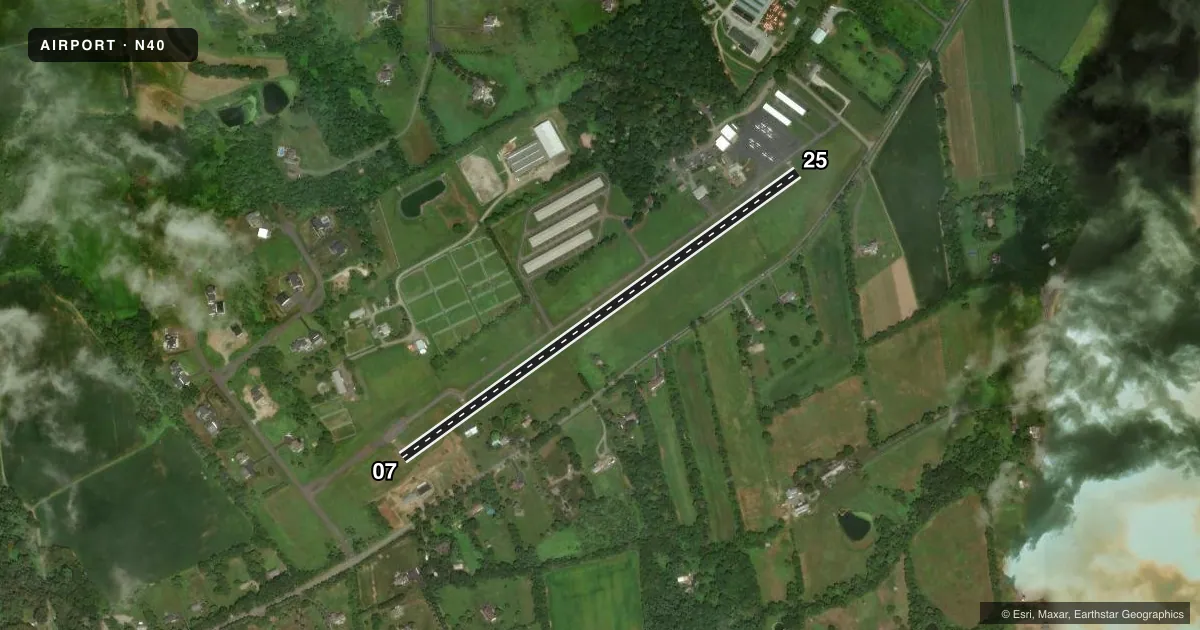
Runways & pattern
Full pagePattern entry · RWY 25
LEFT TRAFFICRunway end performance
| End | TORA | TODA | ASDA | LDA | VGSI | Approach lights | Obstruction |
|---|---|---|---|---|---|---|---|
| 07 | — | — | — | — | PAPI 2-box left(4°) | — | 93', trees, 1020' from thr, 360' R of cntrln, slope 9 |
| 25 | — | — | — | — | PAPI 2-box left(4°) | — | 99', pline, 2070' from thr, 210' R of cntrln, slope 18 |
Declared distances in feet. TORA = takeoff run available, TODA = takeoff distance, ASDA = accelerate-stop, LDA = landing distance.
Airport sketch
Runways drawn to scale from FAA survey coordinates, rendered over satellite imagery. Not for navigation.
Approaches & charts
Services on the field
Fuel grades, oxygen, maintenance, ramp storage and lighting — as declared to the FAA by the airport operator.
Fuel & services
- Fuel
- 100LL
- Oxygen (bottled)
- Not available
- Oxygen (bulk)
- Not available
- Airframe repair
- Major
- Power plant repair
- Major
- Other services
- INSTR,RNTL,SALES
Ramp & ground
- Transient storage
- Tie-down
- Hangar
- Landing fee
- No fee published
- Customs
- Not available
- Lighting schedule
- SEE RMK
- Wind indicator
- Yes
- Segmented circle
- No
Fuel & FBOs
Cheapest 100LL and Jet A on the field and nearby. Always confirm with the FBO before taxi.
Airport notes
Surface conditions, obstructions, local procedures, lighting outages and other notes published with each FAA cycle.
General notes
- HELICOPTER ACTIVITY ON & INVOF ARPT.
- SELF-SERVE FUEL SYSTEM ON NORTH END OF TIE-DOWN RAMP.
- FOR CD CTC ALLENTOWN APCH AT 800-728-6322.
- AVOID OVERFLIGHT OF HORSE FARM (STABLES) 500 FT N OF ACFT HNGRS.
- RWY 07 NOISE ABATEMENT PROCEDURES VFR DEP FLY RWY HDG UNTIL REACHING AT LEAST 1300FT MSL.
- RWY 25 NOISE ABATEMENT PROCEDURES VFR DEP SAFETY PERMITTING AT DEP END OF RWY TURN RIGHT FLY HDG 270 UNTIL REACHING AT LEAST 1300FT MSL.
- APN MAIN RAMP CLSD TO HEL AIR TAX AND HOVER OPS NEAR FUEL PUMP.
- DEER & BIRDS ON & INVOF ARPT.
Lighting notes
- ACTVT REIL RWY 07 & 25; MIRL RWY 07/25; TWY LGTS - CTAF. PAPI RWY 07 & 25 OPR CONSLY.
Approach & departure obstructions
- 2513 FT T-HANGARS 80 FT FM THR 215 FT RIGHT.
- 07UNUSBL BYD 4 DEGS RIGHT OF CNTRLN.
Other notes
- EXISTED PRIOR TO 1959.
VFR map & nearby airports
VFR sectional. Tap any ICAO chip to open that airport.
Key facts · N40
Answer card- ICAO
- N40
- Name
- SKY MANOR
- Location
- PITTSTOWN, NEW JERSEY
- Elevation
- 560 ft MSL
- Traffic pattern altitude
- 1,560 ft MSL (1,000 AGL)
- Control tower
- Non-towered (use CTAF)
- Total runways
- 1
- Longest runway
- 07/25 · 2,900 ft
- Published ILS approaches
- 0
- Published frequencies
- 5
- Magnetic variation
- 13°
- Current flight rules
- VFR
- Current wind
- 220° at 3 kt
- Favored runway now
- RWY 25
Sky Manor Airport sits in Pittstown, New Jersey at 560 ft MSL. It has one runway. Runway 07/25 is 2,900 ft long with asphalt pavement. There is no control tower. Traffic uses CTAF 122.975 or UNICOM 122.975. No ILS approaches are published. Pattern altitude is not published, so use the standard 1,000 ft AGL for light piston traffic unless current guidance says otherwise.
The field is served by Sky Manor Airport on the field. It carries AVGAS 100LL. A self-serve fuel system is on the north end of the tie-down ramp. The airport also has medium intensity runway lights, runway end identifier lights and PAPI on both ends. Taxiway lights are controlled by CTAF. Helicopter activity occurs on and near the airport. The main ramp apron is closed to helicopter air taxi and hover operations near the fuel pump.
For a first-time arrival, pay attention to the published noise abatement notes. On runway 07, VFR departures should fly runway heading until at least 1,300 ft MSL. On runway 25, VFR departures should turn right and track heading 270 until at least 1,300 ft MSL, safety permitting. Deer and birds are present. Avoid overflying the horse farm stables 500 ft north of the hangars. There are also 13 ft T-hangars near the threshold of runway 25, so keep that in mind on short final.