METAR & TAF KDYL
Current METAR
Observed 04:54Z
KDYL 270454Z AUTO 19004KT 10SM FEW065 SCT110 22/16 A2985 RMK AO2 SLP102 T02170156 402890139
- Wind
- 190° @ 4 kt
- Visibility
- 10 SM
- Temp / Dew
- 22°C / 16°C
- Altimeter
- 29.85 inHg
- Clouds
- SCT
- Density alt
- 1,415 ft
- Ceiling
- Unlimited
- Rules
- VFR
Airport info & contacts
Manager on record, flight service, ARTCC, attendance schedule and pattern altitude — published by the FAA and refreshed every 28 days.
Location
- From city
- 2 NM N
- VFR sectional
- NEW YORK
- ARTCC
- ZNY · NEW YORK
- NOTAM facility
- DYL (NOTAM-D)
Airport manager
- Name
- MARCEL BISSCHOPS
- Phone
- 215-340-0707
- Address
- 3879 OLD EASTON RD, DOYLESTOWN PA 18902
Flight service · Hours
- FSS IPT
- WILLIAMSPORT1-800-WX-BRIEF
- Attendance
- 0700-DUSK
Frequencies
Tap any row to copy the frequency to your clipboard.
Runways & pattern
Full pagePattern entry · RWY 23
LEFT TRAFFICRunway end performance
| End | TORA | TODA | ASDA | LDA | VGSI | Approach lights | Obstruction |
|---|---|---|---|---|---|---|---|
| 05 | — | — | — | — | S2L 2-box left(5°) | — | 42', trees, 727' from thr, 265' R of cntrln, slope 12 |
| 23 | — | — | — | — | PAPI 2-box left(3°) | — | 12', road, 318' from thr, 68' R of cntrln, slope 9 |
Declared distances in feet. TORA = takeoff run available, TODA = takeoff distance, ASDA = accelerate-stop, LDA = landing distance.
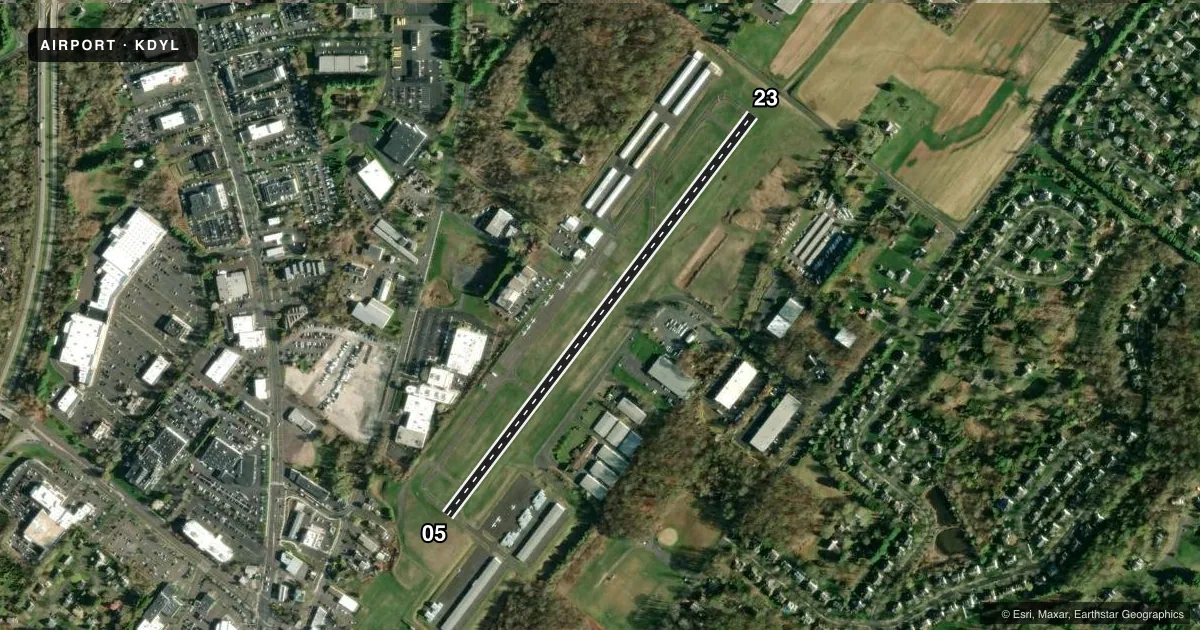
Airport sketch
Runways drawn to scale from FAA survey coordinates, rendered over satellite imagery. Not for navigation.
Approaches & charts
Services on the field
Fuel grades, oxygen, maintenance, ramp storage and lighting — as declared to the FAA by the airport operator.
Fuel & services
- Fuel
- 100LLA
- Oxygen (bottled)
- Not available
- Oxygen (bulk)
- Low pressure
- Airframe repair
- Major
- Power plant repair
- Major
- Other services
- CHTR,INSTR,RNTL
Ramp & ground
- Transient storage
- Tie-down
- Landing fee
- No fee published
- Customs
- Not available
- Lighting schedule
- SEE RMK
- Beacon schedule
- SS-SR
- Beacon
- White / Green (civil land)(WG)
- Wind indicator
- Lighted
- Segmented circle
- Yes
Fuel & FBOs
Cheapest 100LL and Jet A on the field and nearby. Always confirm with the FBO before taxi.
Airport notes
Surface conditions, obstructions, local procedures, lighting outages and other notes published with each FAA cycle.
General notes
- NOISE ABATEMENT PROCEDURES IN EFFECT; CTC AMGR 215-340-0707.
- DEER, GEESE AND OTHER WILDLIFE ON AND INVOF RWY.
- RWY 05 IS USED FOR CROSSWIND & CALM WIND RWY.
- FOR CD CTC PHILADELPHIA APCH AT 800-354-9884.
- RWY 23 APCH RATIO 20:1 TO DTHR.
Lighting notes
- ACTVT REIL 23; MIRL 05/23 - CTAF. MIRL 05/23 OPR CONSLY SS-SR.
Approach & departure obstructions
- 23RWY 23: 5 FT FENCE; 158 FT FM RWY END, 195 FT LEFT.
Other notes
- EXISTED PRIOR TO 05/15/59.
- 1NO SERVICES AVBL CHRISTMAS, NEW YEARS, & THANKSGIVING.
VFR map & nearby airports
VFR sectional. Tap any ICAO chip to open that airport.
Key facts · KDYL
Answer card- ICAO
- KDYL
- Name
- DOYLESTOWN
- Location
- DOYLESTOWN, PENNSYLVANIA
- Elevation
- 393.5 ft MSL
- Traffic pattern altitude
- 1,393.5 ft MSL (1,000 AGL)
- Control tower
- Non-towered (use CTAF)
- Total runways
- 1
- Longest runway
- 05/23 · 3,004 ft
- Published ILS approaches
- 0
- Published frequencies
- 5
- Magnetic variation
- 12°
- Current flight rules
- VFR
- Current wind
- 190° at 4 kt
- Favored runway now
- RWY 23
Doylestown Airport sits in Doylestown, Pennsylvania. Field elevation is 393.5 ft MSL. The airport has one runway. Runway 05/23 is 3,004 ft long, so plan performance with that length in mind. There is no control tower. Clearance delivery is handled through Philadelphia Approach. No ILS approaches are published here.
Pattern altitude is not published. Use the standard 1,000 ft AGL pattern for light piston operations unless current airport guidance says otherwise. The field has medium intensity runway lights on 05/23. They operate continuously from sunset to sunrise. Runway 23 also has runway end identifier lights. Runway 05 is used for crosswind and calm wind operations. Noise abatement procedures are in effect. Contact the airport manager before arrival if you need the current guidance.
Leading Edge Aviation is on the field. It carries 100LL, Jet A and Jet A Prist. Wildlife is also a real factor here. Deer, geese and other animals are reported on and near the runway. That makes the takeoff and landing roll something to stay alert for, especially at dawn and dusk. Check the current FAA Chart Supplement for any updates before you go.