METAR & TAF KCKZ
Current METAR
Observed 13:35Z
KCKZ 271335Z AUTO 00000KT 9SM CLR 24/20 A2986 RMK AO2
- Wind
- 000° @ 0 kt
- Visibility
- 9 SM
- Temp / Dew
- 24°C / 20°C
- Altimeter
- 29.86 inHg
- Clouds
- CLR
- Density alt
- 1,858 ft
- Ceiling
- Unlimited
- Rules
- VFR
Airport info & contacts
Manager on record, flight service, ARTCC, attendance schedule and pattern altitude — published by the FAA and refreshed every 28 days.
Location
- From city
- 1 NM N
- VFR sectional
- NEW YORK
- ARTCC
- ZNY · NEW YORK
- NOTAM facility
- IPT (NOTAM-D)
Airport manager
- Name
- JEAN CURRY
- Phone
- 267-718-4254
- Address
- 1100 N RIDGE RD, PERKASIE PA 18944
Flight service · Hours
- FSS IPT
- WILLIAMSPORT1-800-WX-BRIEF
- Attendance
- 0800-1600
Frequencies
Tap any row to copy the frequency to your clipboard.
Runways & pattern
Full pagePattern entry · RWY 08
LEFT TRAFFICRunway end performance
| End | TORA | TODA | ASDA | LDA | VGSI | Approach lights | Obstruction |
|---|---|---|---|---|---|---|---|
| 08 | — | — | — | — | PAPI 2-box left(3.78°) | — | 23', trees, 247' from thr, 48' R of cntrln, slope 2 |
| 26 | — | — | — | — | PAPI 2-box left(4°) | — | 55', trees, 490' from thr, 289' R of cntrln, slope 5 |
Declared distances in feet. TORA = takeoff run available, TODA = takeoff distance, ASDA = accelerate-stop, LDA = landing distance.
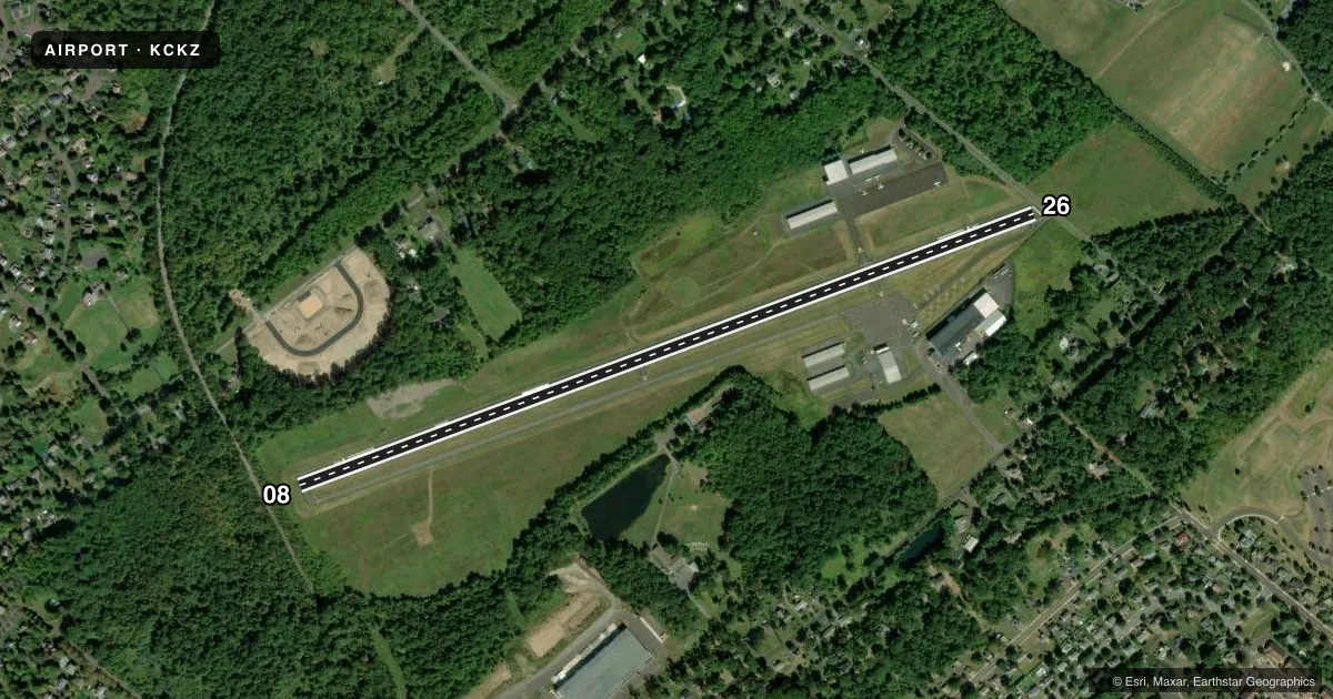
Airport sketch
Runways drawn to scale from FAA survey coordinates, rendered over satellite imagery. Not for navigation.
Approaches & charts
Services on the field
Fuel grades, oxygen, maintenance, ramp storage and lighting — as declared to the FAA by the airport operator.
Fuel & services
- Fuel
- 100LLA
- Oxygen (bottled)
- Not available
- Oxygen (bulk)
- Not available
- Airframe repair
- Major
- Power plant repair
- Major
- Other services
- PAJA
Ramp & ground
- Transient storage
- Tie-down
- Hangar
- Landing fee
- No fee published
- Customs
- Not available
- Lighting schedule
- SEE RMK
- Beacon schedule
- SS-SR
- Beacon
- White / Green (civil land)(WG)
- Wind indicator
- Lighted
- Segmented circle
- No
Fuel & FBOs
Cheapest 100LL and Jet A on the field and nearby. Always confirm with the FBO before taxi.
Airport notes
Surface conditions, obstructions, local procedures, lighting outages and other notes published with each FAA cycle.
General notes
- OCCASIONAL DEER AND WILD TURKEYS INVOF RWY.
- SKYDIVING ACT DLY DAWN TO DUSK.
- FOR CD CTC PHILADELPHIA APCH AT 800-354-9884.
- FOR SVC AFT HRS CALL AMGR.
Lighting notes
- ACTVT PAPI RWY 08 & 26; MIRL 08/26 - CTAF.
Runway surface & condition
- 08/26CLSD TO TOUCH & GO LDGS.
Approach & departure obstructions
- 2610 FT BLAST FENCE AT RWY END. 55 FT TREES, 490FT FM RWY END, 289 FT RIGHT.
- 26RWY DOES NOT HAVE AIMING POINT.
- 08APCH RATIO 13:1 TO DTHR.
- 26APCH RATIO 13:1 TO DTHR.
Other notes
- TPA FOR LIGHT ACFT 800 FT AGL; TPA FOR TURBO PROP & JETS 1200 FT AGL.
- PAJASKYDIVING INSTRUCTION.
VFR map & nearby airports
VFR sectional. Tap any ICAO chip to open that airport.
Key facts · KCKZ
Answer card- ICAO
- KCKZ
- Name
- PENNRIDGE
- Location
- PERKASIE, PENNSYLVANIA
- Elevation
- 567.6 ft MSL
- Traffic pattern altitude
- 1,567.6 ft MSL (1,000 AGL)
- Control tower
- Non-towered (use CTAF)
- Total runways
- 1
- Longest runway
- 08/26 · 4,211 ft
- Published ILS approaches
- 0
- Published frequencies
- 5
- Magnetic variation
- 12°
- Current flight rules
- VFR
- Current wind
- 000° at 0 kt
- Favored runway now
- –
Pennridge Airport sits in Perkasie, Pennsylvania. Field elevation is 567.6 ft MSL. The airport has one runway. Runway 08/26 is 4,211 ft asphalt, so plan for a shorter local field with a single paved strip. There is no control tower. Clearance delivery is handled through Philadelphia Approach. The published approach data shows no ILS approaches. For light aircraft, the pattern altitude is 800 ft AGL. Turbo prop and jet traffic uses 1,200 ft AGL.
Pennridge Airport has one on-field FBO. Pennridge Airport carries 100LL and Jet A. Call (215) 257-0166 for current service details before arrival. Published remarks also note PAPI on both runway ends. Medium intensity runway lights are controlled by CTAF. That helps for night work, but you still want to brief the field carefully before you go.
A few operational items matter here. Skydiving occurs daily from dawn to dusk. Touch-and-go landings are not permitted. The runway has published obstruction notes near both ends. Runway 26 has a 10-foot blast fence at the end. Trees are also noted near the 26 approach path. Occasional deer and wild turkeys are reported in the area. If you are new to the airport, review the current Chart Supplement and coordinate with the airport manager or the FBO directly before arrival.