METAR & TAF N51
N51 does not publish a METAR.
Showing the nearest reporting station: KSMQ (SOMERSET) · 4.0 NM away. Conditions at N51 may differ.
METAR · KSMQ
Observed 05:53Z
KSMQ 270553Z AUTO 00000KT 9SM CLR 19/16 A2982 RMK AO2 SLP097 T01940161 10244 20189 58005
- Wind
- 000° @ 0 kt
- Visibility
- 9 SM
- Temp / Dew
- 19°C / 16°C
- Altimeter
- 29.82 inHg
- Clouds
- CLR
- Density alt
- 839 ft
- Ceiling
- Unlimited
- Rules
- VFR
Airport info & contacts
Manager on record, flight service, ARTCC, attendance schedule and pattern altitude — published by the FAA and refreshed every 28 days.
Location
- From city
- 1 NM NW
- VFR sectional
- NEW YORK
- ARTCC
- ZNY · NEW YORK
- NOTAM facility
- MIV (NOTAM-D)
Airport manager
- Name
- SUZANNE SOLBERG NAGLE
- Phone
- 908-534-4000
- Address
- 39 THOR SOLBERG ROAD, WHITEHOUSE STATION NJ 08889
Flight service · Hours
- FSS MIV
- MILLVILLE1-800-WX-BRIEF
- Attendance
- 0900-1700
Frequencies
Tap any row to copy the frequency to your clipboard.
Runways & pattern
Full pagePattern entry · RWY 04
LEFT TRAFFIC| Runway | Heading (°M) | Length | Surface | Traffic |
|---|---|---|---|---|
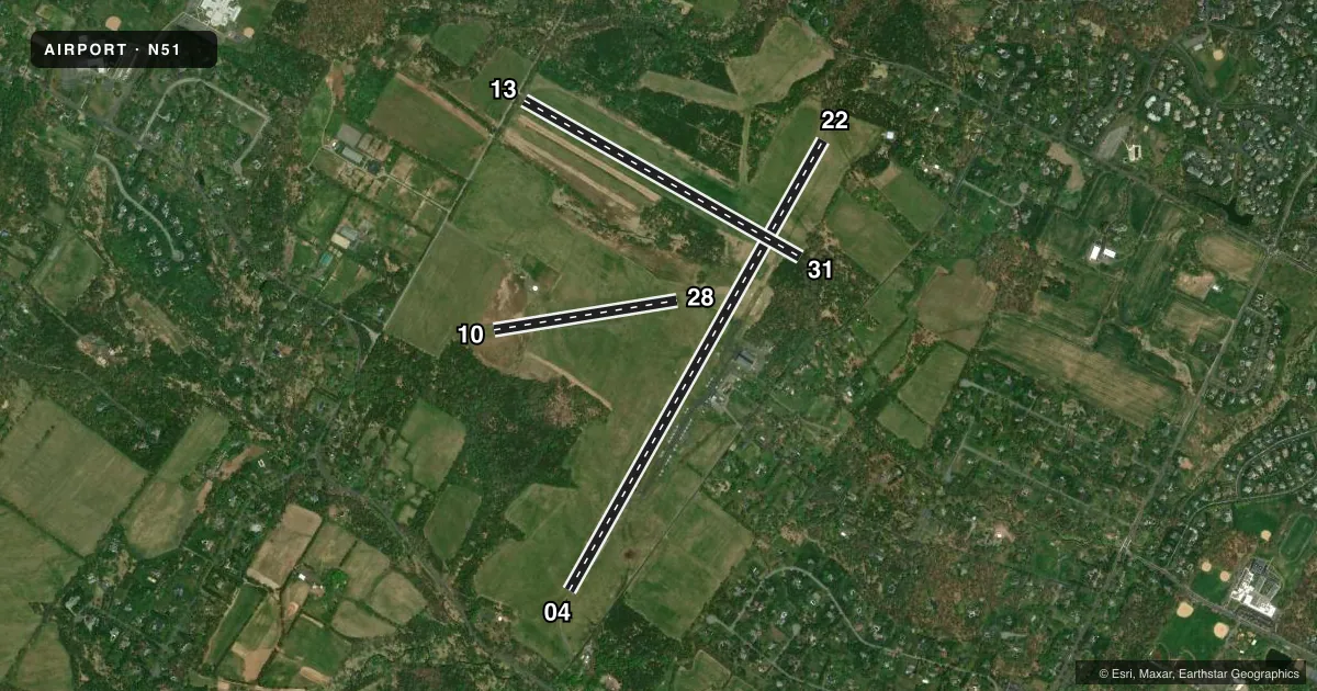
| 04/22 | 19° / 199° | 5,598 ft | ASPH-TURF | Standard L |
| 13/31 | 109° / 289° | 3,444 ft | TURF | Standard L |
| 10/28 | 71° / 251° | 2,010 ft | TURF | Standard L |
Runway end performance
| End | TORA | TODA | ASDA | LDA | VGSI | Approach lights | Obstruction |
|---|---|---|---|---|---|---|---|
| 04 | — | — | — | — | PAPI 2-box left(3°) | — | — |
| 22 | — | — | — | — | PAPI 2-box left(3°) | — | 66', tree, 1655' from thr, 150' R of cntrln, slope 22 |
| 13 | — | — | — | — | — | — | 40', tree, 108' from thr, 99' R of cntrln, slope 2 |
| 31 | — | — | — | — | — | — | 44', trees, 48' from thr, 0' R of cntrln, slope 1 |
| 10 | — | — | — | — | — | — | 58', trees, 602' from thr, 81' R of cntrln, slope 6 |
Declared distances in feet. TORA = takeoff run available, TODA = takeoff distance, ASDA = accelerate-stop, LDA = landing distance.
Airport sketch
Runways drawn to scale from FAA survey coordinates, rendered over satellite imagery. Not for navigation.
Approaches & charts
Services on the field
Fuel grades, oxygen, maintenance, ramp storage and lighting — as declared to the FAA by the airport operator.
Fuel & services
- Fuel
- 100LLA
- Oxygen (bottled)
- Not available
- Oxygen (bulk)
- Low pressure
- Airframe repair
- Major
- Power plant repair
- Major
- Other services
- INSTR,RNTL
Ramp & ground
- Transient storage
- Tie-down
- Hangar
- Landing fee
- No fee published
- Customs
- Not available
- Lighting schedule
- SEE RMK
- Wind indicator
- Yes
- Segmented circle
- No
Fuel & FBOs
Cheapest 100LL and Jet A on the field and nearby. Always confirm with the FBO before taxi.
Airport notes
Surface conditions, obstructions, local procedures, lighting outages and other notes published with each FAA cycle.
General notes
- NO TGL ALL RWYS.
- ALL RWYS DEPT STRAIGHT OUT TO 1200 FT MSL BEFORE TURNING.
- BLIMP AND HOT AIR BALLOON ACTIVITY ON AND INVOF ARPT SPRING THRU FALL.
- GCO AVBL ON FREQ 121.725. IF UNABLE, CTC NEWARK APCH AT 800-645-3206.
- DEER ON AND INVOF ARPT.
- TKOFS & LNDGS PROHIBITED ON RWY 13/31 & RWY 10/28 WHEN ACFT ARE OPERNG ON RWY 4/22.
- CTC OPS, 908-534-4000, PRIOR TO OPERATING ON RWY 10/28.
- HEL FLY FIXED WING TFC PAT AND ALT.
- NO INTXN TKOF ON RWY 04/22.
Lighting notes
- ACTVT REIL RWY 04 & 22; MIRL RWY 04/22 - CTAF. PAPI RWY 04 & 22 OPR CONSLY.
Runway surface & condition
- 04/22RWY 04/22 MIRL ON PAVED 3735 FT BY 50 FT PORTION OF RWY.
Approach & departure obstructions
- 04DSPLCD THLD 544 FT TURF 180 FT WIDE.
- 22DSPLCD THLD 1319 FT TURF 180 FT WIDE.
Other notes
- 1ARPT UNATNDD ALL MAJOR HOLIDAYS & CHRISTMAS & NEW YEARS EVE AFTERNOONS.
- MANAGERCO-MGRS THOR SOLBERG III AND LORRAINE SOLBERG.
- 04/22RWY 04 TURF PORTION POOR AND UNUSBL. CENTER ASPH PORTION EXCELLENT. RWY 22 TURF PORTION POOR AND UNUSBL.
- 10/28NOTICEABLE BUMP WHERE RWY CROSSES GRVL APCH ROAD TO VORTAC.
- 04/22RWY 04 & RWY 22 TURF PTN POOR.
VFR map & nearby airports
VFR sectional. Tap any ICAO chip to open that airport.
Key facts · N51
Answer card- ICAO
- N51
- Name
- SOLBERG/HUNTERDON
- Location
- READINGTON, NEW JERSEY
- Elevation
- 189.6 ft MSL
- Traffic pattern altitude
- 1,189.6 ft MSL (1,000 AGL)
- Control tower
- Non-towered (use CTAF)
- Total runways
- 3
- Longest runway
- 04/22 · 5,598 ft
- Published ILS approaches
- 0
- Published frequencies
- 4
- Magnetic variation
- 10°
- Current flight rules
- VFR
- Current wind
- 000° at 0 kt
- Favored runway now
- –
Solberg/Hunterdon Airport is in Readington, New Jersey. The field elevation is 189.6 ft MSL. It has three runways. The longest is runway 04/22 at 5,598 ft. There is no control tower. No ILS approaches are published.
Pattern altitude is not published. Use 1,000 ft AGL for light piston operations unless the current Chart Supplement says otherwise. Solberg Aviation is on the field. It carries AVGAS 100LL and Jet A. Call (908) 534-4000 for current service details before you go.
The airport has a few items that matter on arrival. Runway 04 and runway 22 have poor turf portions. Runway 22 has a displaced threshold of 1,319 ft. Runway 04 has a displaced threshold of 544 ft. Runway 04/22 lighting is CTAF-controlled. PAPI is available on runways 04 and 22. The airport is unattended on major holidays plus Christmas and New Year's Eve afternoons. Blimp and hot air balloon activity can show up from spring through fall. Deer are also reported on and near the airport. If you plan to use runway 10/28, contact operations at 908-534-4000 before operating there.