METAR & TAF KPHL
Current METAR
Observed 10:54Z
KPHL 271054Z 20007KT 10SM FEW070 SCT100 SCT130 BKN250 22/18 A2984 RMK AO2 SLP105 T02170183 $
- Wind
- 200° @ 7 kt
- Visibility
- 10 SM
- Temp / Dew
- 22°C / 18°C
- Altimeter
- 29.84 inHg
- Clouds
- BKN
- Density alt
- 984 ft
- Ceiling
- 25,000 ft AGL
- Rules
- VFR
Airport info & contacts
Manager on record, flight service, ARTCC, attendance schedule and pattern altitude — published by the FAA and refreshed every 28 days.
Location
- From city
- 5 NM SW
- VFR sectional
- WASHINGTON
- ARTCC
- ZNY · NEW YORK
- NOTAM facility
- PHL (NOTAM-D)
Airport manager
- Name
- ATIF SAEED
- Phone
- 215-937-6914
- Address
- DEPARTMENT OF AVIATION, 2 INTERNATIONAL PLAZA, SUITE 400, PHILADELPHIA PA 19113
Flight service · Hours
- FSS IPT
- WILLIAMSPORT1-800-WX-BRIEF
- Attendance
- ALL
Frequencies
Tap any row to copy the frequency to your clipboard.
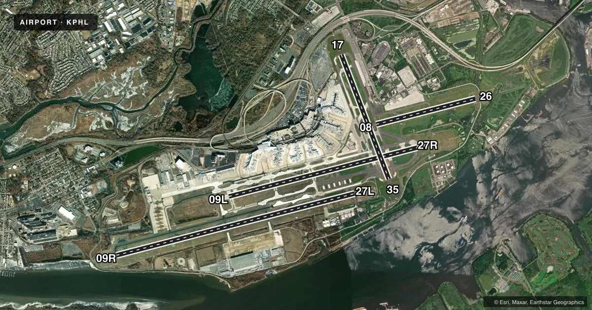
Runways & pattern
Full pagePattern entry · RWY 17
LEFT TRAFFIC| Runway | Heading (°M) | Length | Surface | Traffic |
|---|---|---|---|---|
| 09R/27L | 63° / 243° | 12,000 ft | ASPH | Standard L |
| 09L/27R | 63° / 243° | 9,500 ft | ASPH | Standard L |
| 17/35Favored | 147° / 327° | 6,500 ft | ASPH | Standard L |
| 08/26 | 63° / 244° | 5,001 ft | ASPH | Standard L |
Runway end performance
| End | TORA | TODA | ASDA | LDA | VGSI | Approach lights | Obstruction |
|---|---|---|---|---|---|---|---|
| 09R | 12,000' | 12,000' | 12,000' | 12,000' | PAPI 4-box right(3°) | ALSF2 | 45', trees, 335' from thr, 497' R of cntrln, slope 3 |
| 27L | 12,000' | 12,000' | 11,825' | 9,912' | PAPI 4-box left(3°) | MALSR | 189', boat, 4500' from thr, 827' R of cntrln, slope 23 |
| 09L | 9,500' | 9,500' | 9,500' | 9,500' | — | MALSR | 91', trees, 4090' from thr, 429' R of cntrln, slope 43 |
| 27R | 9,500' | 9,500' | 9,500' | 8,864' | PAPI 4-box left(3°) | MALSR | 189', boat, 4500' from thr, 0' R of cntrln, slope 23 |
| 17 | 6,500' | 6,500' | 6,500' | 6,500' | PAPI 4-box left(3°) | MALSF | 50', tree, 1279' from thr, 516' R of cntrln, slope 21 |
| 35 | 6,500' | 6,500' | 6,500' | 6,500' | PAPI 4-box left(3.15°) | — | 189', boat, 2150' from thr, 0' R of cntrln, slope 10 |
| 08 | 5,001' | 5,001' | 5,001' | 5,001' | — | — | — |
| 26 | 5,001' | 5,001' | 5,001' | 5,001' | PAPI 4-box right(3.15°) | MALSR | 24', tree, 676' from thr, 330' R of cntrln, slope 19 |
Declared distances in feet. TORA = takeoff run available, TODA = takeoff distance, ASDA = accelerate-stop, LDA = landing distance.
Airport sketch
Runways drawn to scale from FAA survey coordinates, rendered over satellite imagery. Not for navigation.
Approaches & charts
ILS · 6
Services on the field
Fuel grades, oxygen, maintenance, ramp storage and lighting — as declared to the FAA by the airport operator.
Fuel & services
- Fuel
- 100LLA
- Oxygen (bottled)
- HIGH/LOW
- Oxygen (bulk)
- HIGH/LOW
- Airframe repair
- Major
- Power plant repair
- Major
- Other services
- AFRT,CARGO,CHTR
Ramp & ground
- Transient storage
- Tie-down
- Hangar
- Landing fee
- Yes
- Customs
- Not available
- Beacon schedule
- SS-SR
- Beacon
- White / Green (civil land)(WG)
- Wind indicator
- Lighted
- Segmented circle
- No
Fuel & FBOs
Cheapest 100LL and Jet A on the field and nearby. Always confirm with the FBO before taxi.
Airport notes
Surface conditions, obstructions, local procedures, lighting outages and other notes published with each FAA cycle.
General notes
- BIRDS ON & INVOF ARPT.
- RWYS 27L, 27R & 35 SHIP CHNL (DELAWARE RIVER) MAX HGT OF SHIPS 189 FT. RWY 26 SHIP CHNL (SCHUYLKILL) MAX HGT OF SHIPS 149 FT.
- ARPT IS LCTD IN A NOISE SENSITIVE AREA. AIRPORT NOISE ABATEMENT TKOF PROCS ARE TO BE USED.
- TCAS EQUIPPED ACFT-TCAS ALERT MAY BE CAUSED BY TRANSPONDER EQUIPPED SHIPS LCTD PHL NAVAL BASE 3 NM E.
- UNLGTD STACK 288 FT MSL (271 FT AGL) 2.3 NM SW OF ARPT.
- RWY 09R ROLLOUT RVR USED FOR RWY 09L MIDPOINT RVR.
- ALL ENGINE RUNUPS RQR PPR FM DUTY OPS OFFICER AT 937-6914/6800; RUNUPS 20 MIN MAX.
- ALL ACFT TRAVELING ON TWY J MUST USE MNM PWR WHEN TURNING S DUE TO JETBLAST CONCERNS.
- TWY J BTN TWYS K3 & Q RSTRD TO ACFT WITH WINGSPANS 171 FT & LESS.
- ONLY NOSE-IN PRKG PMTD ON N REMOTE APNS. PPR FM ARPT OPS FOR ALL ACFT PRKG ON REMOTE APNS; CTC 215-937-6914/6800.
- POSS UNMARKED SHIP OBSTN TRANSITING E OR W ALG THE DELAWARE RIVER REACHING HGTS OF 189 FT - BE ALERT WHEN APCHG PHL RWY 35 & WHENEVER CIRCLING OR VISUALLY APCHG ALL OTHER RWYS.
Runway surface & condition
- 08/26PCR VALUE: 317/F/B/X/T
- 09L/27RPCR VALUE: 702/F/B/W/T
- 09R/27LPCR VALUE: 839/F/C/W/T
- 17/35PCR VALUE: 554/F/C/W/T
- 08/26LND RWY 26 TKOF RWY 08.
Approach & departure obstructions
- 27RRWY 27R LDA 9500 FT AVBL O/R TO ATC.
- 26PAPI UNUSBL BYD 8 DEGS R OF CNTRLN.
VFR map & nearby airports
VFR sectional. Tap any ICAO chip to open that airport.
Key facts · KPHL
Answer card- ICAO
- KPHL
- Name
- PHILADELPHIA INTL
- Location
- PHILADELPHIA, PENNSYLVANIA
- Elevation
- 35.9 ft MSL
- Traffic pattern altitude
- 1,035.9 ft MSL (1,000 AGL)
- Control tower
- Towered · 24
- Total runways
- 4
- Longest runway
- 09R/27L · 12,000 ft
- Published ILS approaches
- 6
- Published frequencies
- 61
- Magnetic variation
- 12°
- Current flight rules
- VFR
- Current wind
- 200° at 7 kt
- Favored runway now
- RWY 17
KPHL is Philadelphia Intl in Philadelphia, Pennsylvania. The field elevation is 35.9 ft MSL. It has 4 asphalt runways. The longest is 12,000 ft on 09R/27L. The tower is open 24 hours. There are 6 ILS approaches, with runway ends served on 09L, 09R, 17, 26, 27L and 27R.
Traffic pattern altitude is not published in the facts. Use the current FAA Chart Supplement before you fly. Atlantic Aviation is on the field. It carries 100LL and Jet A. Call ahead at (215) 492-7060 for current services.
This is a busy Class B airport in a noise sensitive area. Published remarks call for airport noise abatement takeoff procedures. Runup approval is also required from the duty operations officer. Runups are limited to 20 minutes. There is an unlighted stack southwest of the airport. Birds are reported on and near the field. Taxiway and apron restrictions also matter here, including wingspan limits on Taxiway J and prior permission for remote apron parking. If you are new to KPHL, review the current Chart Supplement and plan for heavy airline traffic. Close spacing and runway assignments may not match your first choice.