METAR & TAF N47
N47 does not publish a METAR.
Showing the nearest reporting station: KPTW (HERITAGE FLD) · 5.4 NM away. Conditions at N47 may differ.
METAR · KPTW
Observed 11:54Z
KPTW 271154Z AUTO 25003KT 10SM CLR 21/18 A2987 RMK AO2 SLP111 T02110183 10211 20178 51010
- Wind
- 250° @ 3 kt
- Visibility
- 10 SM
- Temp / Dew
- 21°C / 18°C
- Altimeter
- 29.87 inHg
- Clouds
- CLR
- Density alt
- 1,099 ft
- Ceiling
- Unlimited
- Rules
- VFR
Airport info & contacts
Manager on record, flight service, ARTCC, attendance schedule and pattern altitude — published by the FAA and refreshed every 28 days.
Location
- From city
- 2 NM NW
- VFR sectional
- NEW YORK
- ARTCC
- ZNY · NEW YORK
- NOTAM facility
- IPT (NOTAM-D)
Airport manager
- Name
- CURTIS MEYER
- Phone
- 267-643-9958
- Address
- 1149 GLASGOW ST, POTTSTOWN PA 19464
Flight service · Hours
- FSS IPT
- WILLIAMSPORT1-800-WX-BRIEF
- Attendance
- UNATTND
Frequencies
Tap any row to copy the frequency to your clipboard.
Runways & pattern
Full pagePattern entry · RWY 26
LEFT TRAFFICRunway end performance
| End | TORA | TODA | ASDA | LDA | VGSI | Approach lights | Obstruction |
|---|---|---|---|---|---|---|---|
| 08 | — | — | — | — | — | — | 8', tree, 234' from thr, 114' R of cntrln, slope 4 |
| 26 | — | — | — | — | PAPI 2-box left(3.75°) | — | 10', tree, 278' from thr, 154' R of cntrln, slope 7 |
Declared distances in feet. TORA = takeoff run available, TODA = takeoff distance, ASDA = accelerate-stop, LDA = landing distance.
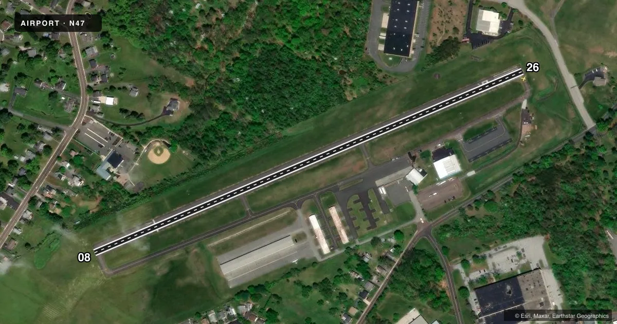
Airport sketch
Runways drawn to scale from FAA survey coordinates, rendered over satellite imagery. Not for navigation.
Approaches & charts
Services on the field
Fuel grades, oxygen, maintenance, ramp storage and lighting — as declared to the FAA by the airport operator.
Fuel & services
- Fuel
- 100LL
- Oxygen (bottled)
- Not available
- Oxygen (bulk)
- Not available
- Airframe repair
- Major
- Power plant repair
- Major
Ramp & ground
- Transient storage
- Tie-down
- Landing fee
- No fee published
- Customs
- Not available
- Lighting schedule
- SEE RMK
- Beacon
- White / Green (civil land)(WG)
- Wind indicator
- Lighted
- Segmented circle
- No
Fuel & FBOs
Cheapest 100LL and Jet A on the field and nearby. Always confirm with the FBO before taxi.
Airport notes
Surface conditions, obstructions, local procedures, lighting outages and other notes published with each FAA cycle.
General notes
- WILDLIFE ON & INVOF ARPT.
- FOR SVC AFT HRS CTC AMGR.
- FOR CD CTC PHILADELPHIA APCH AT 800-354-9884.
Lighting notes
- ACTVT MIRL RWY 08/26; REIL RWY 08/26 - CTAF 122.8.
Approach & departure obstructions
- 2632 FT TREE 106 FT FM RWY END, 238 FT RIGHT.
- 08APCH SLOPE 22:1 TO 380 FT DTHR.
Other notes
- BUILT PRIOR TO 1959.
VFR map & nearby airports
VFR sectional. Tap any ICAO chip to open that airport.
Key facts · N47
Answer card- ICAO
- N47
- Name
- POTTSTOWN MUNI
- Location
- POTTSTOWN, PENNSYLVANIA
- Elevation
- 255.6 ft MSL
- Traffic pattern altitude
- 1,255.6 ft MSL (1,000 AGL)
- Control tower
- Non-towered (use CTAF)
- Total runways
- 1
- Longest runway
- 08/26 · 2,704 ft
- Published ILS approaches
- 0
- Published frequencies
- 5
- Magnetic variation
- 12°
- Current flight rules
- VFR
- Current wind
- 250° at 3 kt
- Favored runway now
- RWY 26
Pottstown Muni is in Pottstown, Pennsylvania. The field elevation is 255.6 ft MSL. It has one runway. Runway 08/26 is 2,704 ft long and asphalt. There is no control tower. CTAF and UNICOM are both 122.8. Clearance delivery is handled through Philadelphia Approach when needed. No ILS approaches are published here.
Pattern altitude is not published, so plan on the standard 1,000 ft AGL unless the current Chart Supplement says otherwise. Morgantown Aero Corporation is on the field. It carries 100LL. The airport uses medium intensity runway lights on 08/26. Runway end identifier lights are also installed. Wildlife is present on and near the airport. Keep a sharp scan on taxi, takeoff and landing.
There are a couple of things a first-time pilot should know. The approach to runway 08 has an obstruction note. The slope is 22 to 1 up to 380 ft beyond the threshold. Runway 26 also has a tree close to the departure end. The airport was built before 1959, so expect a field that has been around a long time rather than a modern layout. If you need after-hours service, contact the airport manager. For any current noise, curfew, or operational details not listed here, check the current FAA Chart Supplement before you go.