METAR & TAF KMQS
Current METAR
Observed 07:55Z
KMQS 270755Z AUTO 00000KT 9SM CLR 18/18 A2985 RMK AO2 LTG DSNT S T01840180 $
- Wind
- 000° @ 0 kt
- Visibility
- 9 SM
- Temp / Dew
- 18°C / 18°C
- Altimeter
- 29.85 inHg
- Clouds
- CLR
- Density alt
- 1,265 ft
- Ceiling
- Unlimited
- Rules
- VFR
Airport info & contacts
Manager on record, flight service, ARTCC, attendance schedule and pattern altitude — published by the FAA and refreshed every 28 days.
Location
- From city
- 2 NM W
- VFR sectional
- WASHINGTON
- ARTCC
- ZNY · NEW YORK
- NOTAM facility
- IPT (NOTAM-D)
Airport manager
- Name
- CONNOR LAPPS
- Phone
- 610-802-2291
- Address
- 1 EARHART DR SUITE 2, COATESVILLE PA 19320
Flight service · Hours
- FSS IPT
- WILLIAMSPORT1-800-WX-BRIEF
- Attendance
- 0600-2200
Frequencies
Tap any row to copy the frequency to your clipboard.
Runways & pattern
Full pagePattern entry · RWY 11
LEFT TRAFFICRunway end performance
| End | TORA | TODA | ASDA | LDA | VGSI | Approach lights | Obstruction |
|---|---|---|---|---|---|---|---|
| 11 | — | — | — | — | PAPI 4-box right(3.2°) | — | 56', tree, 777' from thr, 504' R of cntrln, slope 10 |
| 29 | — | — | — | — | PAPI 4-box left(3°) | — | 14', trees, 238' from thr, 467' R of cntrln, slope 2 |
Declared distances in feet. TORA = takeoff run available, TODA = takeoff distance, ASDA = accelerate-stop, LDA = landing distance.
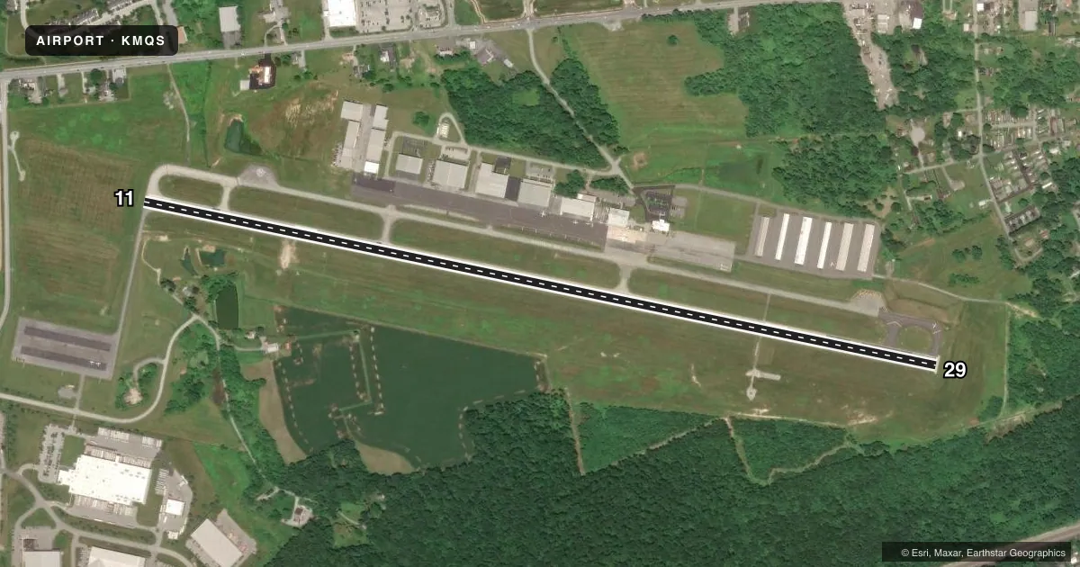
Airport sketch
Runways drawn to scale from FAA survey coordinates, rendered over satellite imagery. Not for navigation.
Approaches & charts
ILS · 1
Services on the field
Fuel grades, oxygen, maintenance, ramp storage and lighting — as declared to the FAA by the airport operator.
Fuel & services
- Fuel
- 100LLA
- Oxygen (bottled)
- HIGH/LOW
- Oxygen (bulk)
- HIGH/LOW
- Airframe repair
- Major
- Power plant repair
- Major
- Other services
- AVNCS,INSTR,RNTL,SALES
Ramp & ground
- Transient storage
- Tie-down
- Hangar
- Landing fee
- No fee published
- Customs
- Not available
- Lighting schedule
- SEE RMK
- Beacon schedule
- SS-SR
- Beacon
- White / Green (civil land)(WG)
- Wind indicator
- Lighted
- Segmented circle
- No
Fuel & FBOs
Cheapest 100LL and Jet A on the field and nearby. Always confirm with the FBO before taxi.
Airport notes
Surface conditions, obstructions, local procedures, lighting outages and other notes published with each FAA cycle.
General notes
- MIGRATORY BIRDS & DEER ON & INVOF ARPT.
- NOISE ABATEMENT PROC IN EFFECT, CTC AMGR CELL.
- +164 FT WATER TWR 1343 FT FM RY 11 THR 1842 FT R MKD WITH STROBE LGT DALGT HRS; STD OBSTN LGT NGT HRS.
- HELICOPTER OPS INVOF ARPT SOUTH AND SOUTHWEST OF RY 11 THLD.
- HELICOPTER TRAFFIC REQUESTED TO LAND AND TKOF FM RY ONLY. HELICOPTER HOVER TAXIING, TKOFS, & LNDGS PROHIBITED FM TWY ALPHA.
- HOVER TAXI ALONG TXY ALPHA PROHIBITED. WHEEL TAXI ON TXY OR HOVER FM RY TO RAMP SIDE PARKING SPOT BY CROSSING PERPENDICULAR TO ALPHA.
- FOR CD CTC PHILADELPHIA APCH AT 800-354-9884.
Lighting notes
- DUSK-DAWN. ACTVT REIL RWY 11/29; HIRL RWY 11/29 - CTAF.
Approach & departure obstructions
- 11UNUSBL BYD 6 DEG LEFT OF CRS.
Other notes
- 1FOR SVC AFTER HRS CNT 610-384-9000
VFR map & nearby airports
VFR sectional. Tap any ICAO chip to open that airport.
Key facts · KMQS
Answer card- ICAO
- KMQS
- Name
- CHESTER COUNTY G O CARLSON
- Location
- COATESVILLE, PENNSYLVANIA
- Elevation
- 660.2 ft MSL
- Traffic pattern altitude
- 1,660.2 ft MSL (1,000 AGL)
- Control tower
- Non-towered (use CTAF)
- Total runways
- 1
- Longest runway
- 11/29 · 5,400 ft
- Published ILS approaches
- 1
- Published frequencies
- 5
- Magnetic variation
- 11°
- Current flight rules
- VFR
- Current wind
- 000° at 0 kt
- Favored runway now
- –
Chester County G O Carlson Airport is in Coatesville, Pennsylvania. The field elevation is 660.2 ft MSL. KMQS has one runway, 11/29, which is 5,400 ft long and paved with asphalt. There is no control tower. The published pattern altitude is not listed, so use the standard 1,000 ft AGL pattern unless current local guidance says otherwise.
The airport has one ILS approach to runway 29. That makes the westbound end the one to study if you are planning an instrument arrival. CTAF and UNICOM are both 122.7. Philadelphia Approach handles approach and departure on 124.35 and 319.15. Clearance delivery is 125.6. For clearance delivery by phone, the Chart Supplement lists Philadelphia Approach at 800-354-9884.
Signature Aviation is the on-field FBO. It carries 100LL and Jet A. For after-hours service, the published remarks point pilots to 610-384-9000. Noise abatement procedures are in effect. Check the current Chart Supplement and call the airport manager before arrival if you need the local procedure. Be alert for helicopter activity south and southwest of runway 11. The field also has bird and deer activity in the area. A 164-foot water tower sits near the runway 11 end. The runway 11 visual glide slope indicator is unusable more than 6 degrees left of course.