METAR & TAF 58M
58M does not publish a METAR.
Showing the nearest reporting station: KILG (NEW CASTLE) · 13.7 NM away. Conditions at 58M may differ.
METAR · KILG
Observed 12:51Z
KILG 271251Z 25004KT 10SM CLR 23/20 A2986 RMK AO2 SLP112 T02330200 PNO $
- Wind
- 250° @ 4 kt
- Visibility
- 10 SM
- Temp / Dew
- 23°C / 20°C
- Altimeter
- 29.86 inHg
- Clouds
- CLR
- Density alt
- 1,166 ft
- Ceiling
- Unlimited
- Rules
- VFR
Airport info & contacts
Manager on record, flight service, ARTCC, attendance schedule and pattern altitude — published by the FAA and refreshed every 28 days.
Location
- From city
- 3 NM SW
- VFR sectional
- WASHINGTON
- ARTCC
- ZNY · NEW YORK
- NOTAM facility
- DCA (NOTAM-D)
Airport manager
- Name
- MARY HALL
- Phone
- (410) 398-0234
- Address
- P.O. BOX 445, ELKTON MD 21922
Flight service · Hours
- FSS DCA
- LEESBURG1-800-WX-BRIEF
- Attendance
- 0900-1600
Frequencies
Tap any row to copy the frequency to your clipboard.
Runways & pattern
Full pagePattern entry · RWY 31
LEFT TRAFFICRunway end performance
| End | TORA | TODA | ASDA | LDA | VGSI | Approach lights | Obstruction |
|---|---|---|---|---|---|---|---|
| 13 | — | — | — | — | PAPI 2-box right(5°) | — | 50', trees, 804' from thr, 42' R of cntrln, slope 12 |
| 31 | — | — | — | — | PAPI 2-box left(4°) | — | 92', trees, 506' from thr, 89' R of cntrln, slope 3 |
Declared distances in feet. TORA = takeoff run available, TODA = takeoff distance, ASDA = accelerate-stop, LDA = landing distance.
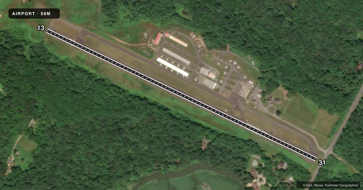
Airport sketch
Runways drawn to scale from FAA survey coordinates, rendered over satellite imagery. Not for navigation.
Approaches & charts
Services on the field
Fuel grades, oxygen, maintenance, ramp storage and lighting — as declared to the FAA by the airport operator.
Fuel & services
- Fuel
- 100LL
- Airframe repair
- Minor
- Power plant repair
- Minor
- Other services
- AVNCS
Ramp & ground
- Transient storage
- Tie-down
- Landing fee
- No fee published
- Lighting schedule
- SEE RMK
- Beacon schedule
- SEE RMK
- Beacon
- White / Green (civil land)(WG)
- Wind indicator
- Lighted
- Segmented circle
- No
Fuel & FBOs
Cheapest 100LL and Jet A on the field and nearby. Always confirm with the FBO before taxi.
Airport notes
Surface conditions, obstructions, local procedures, lighting outages and other notes published with each FAA cycle.
General notes
- DEER & BIRDS ON & INVOF ARPT.
- REDUCED BRAKING ACTION RWY 13 DOWNHILL 1.5 DEG.
- CALM/LIGHT WIND USE RWY 31.
- FOR CD CTC PHILADELPHIA APCH AT (800) 354-9884.
Lighting notes
- ACTVT ROTG BCN - 123.0.
- ACTVT REIL RWY 13 & 31; PAPI RWY 13 & 31; MIRL RWY 13/31 - 123.0.
Fuel notes
- 100LLSELF SERVE.
Runway surface & condition
- 13/31RWY 13/31 NO TGL.
Approach & departure obstructions
- 31PLINE, MKD 10 FT, 40 FT FM THR. TREES 35 FT, 145 FT FM THR.
- 13FADED.
- 31FADED.
- 13APCH SLOPE 20:1 TO DSPLCD THR AT CNTRLN.
- 31APCH SLOPE 20:1 TO DSPLCD THR AT CNTRLN.
Other notes
- VFR PVT USE ONLY.
- OWNERCJ FLIGHT CLA LLC DBA CLAREMONT AIRPORT.
- 13/31UNFILLED CRACKS, ALLIGATOR CRACKING, LATERAL & LONGL CRACKING, VEG GROWTH, OXIDATION.
VFR map & nearby airports
VFR sectional. Tap any ICAO chip to open that airport.
Key facts · 58M
Answer card- ICAO
- 58M
- Name
- CLAREMONT
- Location
- ELKTON, MARYLAND
- Elevation
- 106.4 ft MSL
- Traffic pattern altitude
- 1,106.4 ft MSL (1,000 AGL)
- Control tower
- Non-towered (use CTAF)
- Total runways
- 1
- Longest runway
- 13/31 · 2,989 ft
- Published ILS approaches
- 0
- Published frequencies
- 4
- Magnetic variation
- 12°
- Current flight rules
- VFR
- Current wind
- 250° at 4 kt
- Favored runway now
- RWY 31
Claremont Airport (58M) sits in Elkton, Maryland. Field elevation is 106.4 ft MSL. It has one runway, 13/31, which is 2,989 ft long. There is no control tower. No ILS approaches are published here. The pattern altitude is not published, so plan on the standard 1,000 ft AGL for light piston operations unless the current FAA Chart Supplement says otherwise.
Claremont is a VFR private-use field only. The published remarks matter here. Runway 31 has a marked power line close to the threshold. Trees are also close in on that end. The approach slope to runway 31 is 20 to 1 to the displaced threshold at centerline. Deer and birds are reported on and near the airport. Runway 13 has reduced braking action and a downhill slope of 1.5 degrees. Runway 13/31 also has faded markings, surface cracking and some vegetation growth. Use runway 31 when winds are calm or light.
Claremont Airport on field carries self-serve 100LL. The field uses CTAF 122.8 and UNICOM 122.8. Philadelphia Approach and Departure are on 118.35 and 323.1. The runway end identifier lights, PAPI and medium intensity runway lights are installed on 13/31. The medium intensity lights operate on frequency 123.0.