METAR & TAF N57
N57 does not publish a METAR.
Showing the nearest reporting station: KMQS (CHESTER COUNTY G O CARLSON) · 9.9 NM away. Conditions at N57 may differ.
METAR · KMQS
Observed 12:15Z
KMQS 271215Z AUTO 29005KT 9SM CLR 21/20 A2987 RMK AO2 T02110200 $
- Wind
- 290° @ 5 kt
- Visibility
- 9 SM
- Temp / Dew
- 21°C / 20°C
- Altimeter
- 29.87 inHg
- Clouds
- CLR
- Density alt
- 1,322 ft
- Ceiling
- Unlimited
- Rules
- VFR
Airport info & contacts
Manager on record, flight service, ARTCC, attendance schedule and pattern altitude — published by the FAA and refreshed every 28 days.
Location
- From city
- 1 NM W
- VFR sectional
- WASHINGTON
- ARTCC
- ZNY · NEW YORK
- NOTAM facility
- IPT (NOTAM-D)
Airport manager
- Name
- JONATHAN MARTIN
- Phone
- 610-268-2619
- Address
- 1235 NEWARK ROAD, TOUGHKENAMON PA 19374
Flight service · Hours
- FSS IPT
- WILLIAMSPORT1-800-WX-BRIEF
- Attendance
- 0800 - 1700
Frequencies
Tap any row to copy the frequency to your clipboard.
Runways & pattern
Full pagePattern entry · RWY 24
LEFT TRAFFICRunway end performance
| End | TORA | TODA | ASDA | LDA | VGSI | Approach lights | Obstruction |
|---|---|---|---|---|---|---|---|
| 06 | — | — | — | — | — | — | 63', trees, 248' from thr, 239' R of cntrln, slope 0 |
| 24 | — | — | — | — | — | — | 17', trees, 307' from thr, 177' R of cntrln, slope 6 |
Declared distances in feet. TORA = takeoff run available, TODA = takeoff distance, ASDA = accelerate-stop, LDA = landing distance.
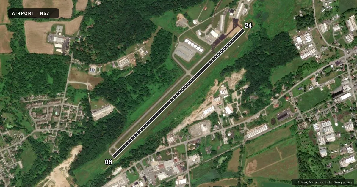
Airport sketch
Runways drawn to scale from FAA survey coordinates, rendered over satellite imagery. Not for navigation.
Approaches & charts
Services on the field
Fuel grades, oxygen, maintenance, ramp storage and lighting — as declared to the FAA by the airport operator.
Fuel & services
- Fuel
- 100LL
- Oxygen (bottled)
- Not available
- Oxygen (bulk)
- Not available
- Airframe repair
- Major
- Power plant repair
- Major
- Other services
- GLD,INSTR,RNTL,TOW
Ramp & ground
- Transient storage
- Tie-down
- Hangar
- Landing fee
- Yes
- Customs
- Not available
- Lighting schedule
- SEE RMK
- Beacon schedule
- SS-SR
- Beacon
- White / Green (civil land)(WG)
- Wind indicator
- Lighted
- Segmented circle
- No
Fuel & FBOs
Cheapest 100LL and Jet A on the field and nearby. Always confirm with the FBO before taxi.
Airport notes
Surface conditions, obstructions, local procedures, lighting outages and other notes published with each FAA cycle.
General notes
- RWY 06 NOISE ABATEMENT CLIMB TO 1200 FT MSL BFR TURNING CROSSWIND.
- FOR ASST AFTER HRS CTC 610-476-1702
- DEER AND OTHER WILDLIFE ON AND INVOF ARPT.
- OVNGT PRKG FEE.
- FOR CD CTC PHILADELPHIA APCH AT 800-354-9884.
Lighting notes
- ACTVT MIRL RWY 06/24 - CTAF.
Approach & departure obstructions
- 06RWY 06 HAS 13 FT TREES; 181 FT FM RWY END AND 163 FT RIGHT.
- 06CTLG OBSTN EXCEEDS 45 DEG SLP.
Other notes
- VFR USE ONLY
- GLDGLIDER OPS INVOF AIRPORT.
- 06/24TURF SFC SOUTH OF RWY FOR GLIDER RECOVERY ONLY.
VFR map & nearby airports
VFR sectional. Tap any ICAO chip to open that airport.
Key facts · N57
Answer card- ICAO
- N57
- Name
- NEW GARDEN
- Location
- TOUGHKENAMON, PENNSYLVANIA
- Elevation
- 435.2 ft MSL
- Traffic pattern altitude
- 1,435.2 ft MSL (1,000 AGL)
- Control tower
- Non-towered (use CTAF)
- Total runways
- 1
- Longest runway
- 06/24 · 3,693 ft
- Published ILS approaches
- 0
- Published frequencies
- 5
- Magnetic variation
- 9°
- Current flight rules
- VFR
- Current wind
- 290° at 5 kt
- Favored runway now
- RWY 24
New Garden Airport is in Toughkenamon, Pennsylvania. The field elevation is 435.2 ft MSL. It has one runway, 06/24, which is 3,693 ft long and asphalt. There is no control tower. The airport uses CTAF 123.05 and UNICOM 123.05. No ILS approaches are published.
Pattern altitude is not published. Use the standard 1,000 ft AGL for light piston operations unless the current Chart Supplement or local briefing says otherwise. The airport sits in a busy part of southeastern Pennsylvania. Glider activity is published in the area. Deer and other wildlife are also noted on and near the field. Runway 06 has a published noise abatement note. Climb to 1,200 ft MSL before turning crosswind.
New Garden Flying Field is on the field. It carries 100LL. For clearance delivery, Philadelphia Approach is listed at 800-354-9884. Medium intensity runway lights on 06/24 are activated by CTAF. There is also a turf surface south of the runway for glider recovery only. Pilots should watch the departure end of runway 06. Published remarks note trees close to the runway end and an obstruction that exceeds a 45 degree slope near that end. This is a VFR-only field, so plan accordingly and verify current details before arrival.