METAR & TAF S37
S37 does not publish a METAR.
Showing the nearest reporting station: KLNS (LANCASTER) · 6.4 NM away. Conditions at S37 may differ.
METAR · KLNS
Observed 07:53Z
KLNS 260753Z AUTO 00000KT 10SM BKN110 18/13 A2997 RMK AO2 SLP145 T01780128
- Wind
- 000° @ 0 kt
- Visibility
- 10 SM
- Temp / Dew
- 18°C / 13°C
- Altimeter
- 29.97 inHg
- Clouds
- BKN
- Density alt
- 757 ft
- Ceiling
- 11,000 ft AGL
- Rules
- VFR
Airport info & contacts
Manager on record, flight service, ARTCC, attendance schedule and pattern altitude — published by the FAA and refreshed every 28 days.
Location
- From city
- 0 NM N
- VFR sectional
- NEW YORK
- ARTCC
- ZNY · NEW YORK
- NOTAM facility
- IPT (NOTAM-D)
Airport manager
- Name
- DOUG FRETZ
- Phone
- 717-394-6476
- Address
- 311 AIRPORT DR PO BOX 7, SMOKETOWN PA 17576
Flight service · Hours
- FSS IPT
- WILLIAMSPORT1-800-WX-BRIEF
- Attendance
- MON-SAT · 0800-1700
- SUN · 1300-1700
Frequencies
Tap any row to copy the frequency to your clipboard.
Runways & pattern
Full pagePattern entry · RWY 10
LEFT TRAFFICRunway end performance
| End | TORA | TODA | ASDA | LDA | VGSI | Approach lights | Obstruction |
|---|---|---|---|---|---|---|---|
| 10 | — | — | — | — | — | — | 44', road, 567' from thr, 100' R of cntrln, slope 8 |
Declared distances in feet. TORA = takeoff run available, TODA = takeoff distance, ASDA = accelerate-stop, LDA = landing distance.
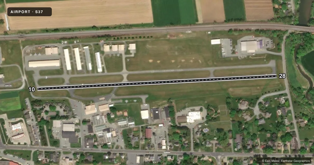
Airport sketch
Runways drawn to scale from FAA survey coordinates, rendered over satellite imagery. Not for navigation.
Approaches & charts
Services on the field
Fuel grades, oxygen, maintenance, ramp storage and lighting — as declared to the FAA by the airport operator.
Fuel & services
- Fuel
- 100LLUL94
- Airframe repair
- Major
- Power plant repair
- Major
- Other services
- CHTR,INSTR
Ramp & ground
- Transient storage
- Tie-down
- Landing fee
- No fee published
- Lighting schedule
- SS-SR
- Beacon schedule
- SS-SR
- Beacon
- White / Green (civil land)(WG)
- Wind indicator
- Lighted
- Segmented circle
- Yes
Fuel & FBOs
Cheapest 100LL and Jet A on the field and nearby. Always confirm with the FBO before taxi.
Airport notes
Surface conditions, obstructions, local procedures, lighting outages and other notes published with each FAA cycle.
General notes
- FOR CD CTC HARRISBURG APCH AT 800-932-0712.
- RWY 28 PREFERRED RWY FOR LNDG IN LIGHT WIND CONDITIONS
Approach & departure obstructions
- 10RWY 10 +10 FT PRIVATE ROAD 50 FT FROM RWY END ACROSS CENTERLINE.
- 28RY 28 HAS +9 FT PUBLIC ROAD 85 FT FM RY END ACROSS CNTRLN.
- 10RWY 10 APCH SLP 23:1 TO DTHR.
VFR map & nearby airports
VFR sectional. Tap any ICAO chip to open that airport.
Key facts · S37
Answer card- ICAO
- S37
- Name
- SMOKETOWN
- Location
- SMOKETOWN, PENNSYLVANIA
- Elevation
- 370 ft MSL
- Traffic pattern altitude
- 1,370 ft MSL (1,000 AGL)
- Control tower
- Non-towered (use CTAF)
- Total runways
- 1
- Longest runway
- 10/28 · 2,750 ft
- Published ILS approaches
- 0
- Published frequencies
- 2
- Magnetic variation
- 11°
- Current flight rules
- VFR
- Current wind
- 000° at 0 kt
- Favored runway now
- –
Smoketown Airport is in Smoketown, Pennsylvania. The field elevation is 370 ft MSL. It has one runway, 10/28 and the longest runway is 2,750 ft of asphalt. There is no control tower. CTAF and UNICOM are both 123.05.
No ILS approaches are published here. Pattern altitude is not published in the facts, so use the standard 1,000 ft AGL pattern unless the current Chart Supplement says otherwise. Smoketown Aviation is on the field. It carries 100LL and UL94. Call them at (717) 394-6476 for current service details.
A few published remarks matter for planning. Runway 28 is the preferred landing runway in light wind. Runway 10 has a displaced threshold with a steep approach slope, so brief that side before you go in. There is also a public road near the Runway 28 end. There is a private road near the Runway 10 end. For clearance delivery, contact Harrisburg Approach at 800-932-0712. This is a small non-towered field, so expect local traffic and keep your radio calls tight.