METAR & TAF 08N
08N does not publish a METAR.
Showing the nearest reporting station: KLNS (LANCASTER) · 10.3 NM away. Conditions at 08N may differ.
METAR · KLNS
Observed 12:53Z
KLNS 271253Z 30005KT 10SM CLR 23/18 A2986 RMK AO2 SLP109 T02280183
- Wind
- 300° @ 5 kt
- Visibility
- 10 SM
- Temp / Dew
- 23°C / 18°C
- Altimeter
- 29.86 inHg
- Clouds
- CLR
- Density alt
- 1,716 ft
- Ceiling
- Unlimited
- Rules
- VFR
Airport info & contacts
Manager on record, flight service, ARTCC, attendance schedule and pattern altitude — published by the FAA and refreshed every 28 days.
Location
- From city
- 5 NM SE
- VFR sectional
- NEW YORK
- ARTCC
- ZNY · NEW YORK
- NOTAM facility
- IPT (NOTAM-D)
Airport manager
- Name
- CALEB KELLER
- Phone
- 717-598-0057
- Address
- 341 LAKEVIEW DR, LITITZ PA 17543
Flight service · Hours
- FSS IPT
- WILLIAMSPORT1-800-WX-BRIEF
- Attendance
- Unattended
Frequencies
Tap any row to copy the frequency to your clipboard.
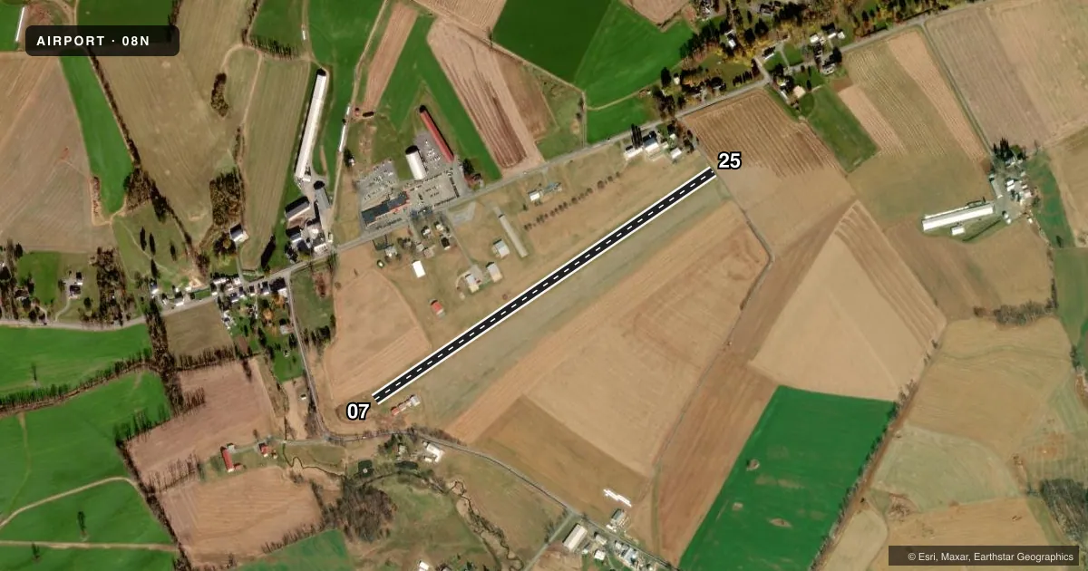
Runways & pattern
Full pagePattern entry · RWY 25
LEFT TRAFFICRunway end performance
| End | TORA | TODA | ASDA | LDA | VGSI | Approach lights | Obstruction |
|---|---|---|---|---|---|---|---|
| 07 | — | — | — | — | — | — | 26', trees, 64' from thr, 64' R of cntrln, slope 2 |
| 25 | — | — | — | — | — | — | 45', tree, 28' from thr, 202' R of cntrln, slope 0 |
Declared distances in feet. TORA = takeoff run available, TODA = takeoff distance, ASDA = accelerate-stop, LDA = landing distance.
Airport sketch
Runways drawn to scale from FAA survey coordinates, rendered over satellite imagery. Not for navigation.
Approaches & charts
Services on the field
Fuel grades, oxygen, maintenance, ramp storage and lighting — as declared to the FAA by the airport operator.
Fuel & services
- Fuel
- 100LL
- Oxygen (bottled)
- Not available
- Oxygen (bulk)
- Not available
- Airframe repair
- Not available
- Power plant repair
- Not available
Ramp & ground
- Transient storage
- Tie-down
- Landing fee
- No fee published
- Customs
- Not available
- Lighting schedule
- SEE RMK
- Beacon schedule
- SEE RMK
- Beacon
- White / Green (civil land)(WG)
- Wind indicator
- Lighted
- Segmented circle
- No
Fuel & FBOs
Cheapest 100LL and Jet A on the field and nearby. Always confirm with the FBO before taxi.
Airport notes
Surface conditions, obstructions, local procedures, lighting outages and other notes published with each FAA cycle.
General notes
- FOR CD CTC HARRISBURG APCH AT 800-932-0712.
Lighting notes
- ACTVT ROTG BCN - 121.9.
- ACTVT LIRL RWY 07/25 - 121.9.
Fuel notes
- 100LL100LL SELF SERVE
Runway surface & condition
- 07/25THLDS AND DSPLCD THLDS MARKED WITH LGTS.
- 07/25NSTD LIRL; RWY ENDS IDENTIFIED BY 2 STROBE LGTS & NSTD THLD LGT FIXTURES.
Approach & departure obstructions
- 07APCH SLOPE 29:1 TO DTHR.
- 25CTLNG OBSTN EXCEEDS A 45 DEG SLP.
Other notes
- VFR USE ONLY
- ACTVT WDI LGT - 121.9.
VFR map & nearby airports
VFR sectional. Tap any ICAO chip to open that airport.
Key facts · 08N
Answer card- ICAO
- 08N
- Name
- KELLER BROTHERS
- Location
- LEBANON, PENNSYLVANIA
- Elevation
- 550 ft MSL
- Traffic pattern altitude
- 1,550 ft MSL (1,000 AGL)
- Control tower
- Non-towered (use CTAF)
- Total runways
- 1
- Longest runway
- 07/25 · 2,692 ft
- Published ILS approaches
- 0
- Published frequencies
- 3
- Magnetic variation
- 12°
- Current flight rules
- VFR
- Current wind
- 300° at 5 kt
- Favored runway now
- RWY 25
Keller Brothers Airport sits in Lebanon, Pennsylvania. Field elevation is 550 ft MSL. It has one runway. The longest is 2,692 ft of turf, runway 07/25. This is a non-towered field. The published pattern altitude is not listed, so use standard 1,000 ft AGL for light piston operations unless the current Chart Supplement says otherwise.
No ILS approaches are published here. The field is for VFR use only. Harrisburg Approach handles clearance delivery. The published frequencies are 122.9 for CTAF. Harrisburg approach and departure use 126.45 or 281.525. On the runway, pay attention to the published lighting setup. The ends are marked with strobe lights and nonstandard threshold fixtures. Low-intensity runway lights are activated on 121.9. The rotating beacon and wind direction indicator light also use 121.9.
Keller Brothers Airport has Keller Brothers Airport on the field. It carries self-serve 100LL. The published remarks also note an obstruction on the 07 approach side. There is a ceiling obstruction on the 25 side. The approach slope to the displaced threshold on 07 is 29 to 1. For a first-time arrival, this is a short turf strip with published lighting quirks and obstruction notes. Check the current FAA Chart Supplement before you go. Confirm the latest runway condition, lighting use and any local procedures with the airport operator or the FBO directly by phone.